
Lake Tláhuac, Ciudad de México Municipality of Tláhuac Valley of Mexico
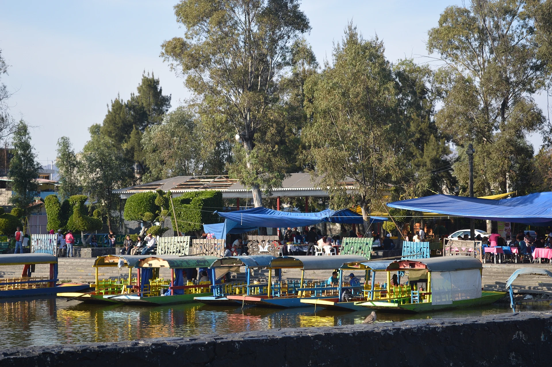
San Pedro Tláhuac's boat landing: trajineras past vegetable chinampas, herons and ducks, with fewer boats and crowds than Xochimilco.
From Mexico City: 40 min by car (30 km by road) How to get there ↓
Near here
See everything nearby ↓


Plan your visit to Lago de los Reyes Aztecas
Where to stay near Lago de los Reyes Aztecas
Compare hotels, posadas and guest houses in Lago de los Reyes Aztecas.
Tours to Lago de los Reyes Aztecas
Day trips and guided outings from Tepoztlán often include Lago de los Reyes Aztecas; with a local guide you can get there without a car.
 Tours from Mexico City
Teotihuacan pyramids morning or afternoon without tourist traps
★ 4.9 (10,269) · From US$59
How to get to Lago de los Reyes Aztecas
- From Mexico City: about 40 min by road (~30 km)
- Nearest airport: Mexico City (MEX), 1 h 25 min by car to Tepoztlán
Links open a partner site. We may earn a commission if you book, at no cost to you.
Tours from Mexico City, near Lago de los Reyes Aztecas


Tours, prices and ratings from Viator, checked weekly. We may earn a commission if you book.
About Lago de los Reyes Aztecas
In the village of San Pedro Tláhuac, east of Xochimilco, a small lake of almost two hectares survives from the web of canals that once fed Tenochtitlan. The village grew up on the island of Cuitláhuac, in the middle of the old lake, and its chinampas are still its main farmland: the El Bordo canal, which joins the Canal de Chalco, empties into this lake, and from here the waterways run on to Xochimilco.
The landing is far calmer than Xochimilco's. In 2022 it had about 40 trajineras, against more than a hundred at each Xochimilco landing, and an hour cost 400 pesos, up to 100 less; you can bring your own food and drink at no extra charge. Boatmen double as guides, poling past chinampas of lettuce, parsley, coriander, spinach, broccoli and epazote, greenhouses, beds of tule and reed, and nesting spots for herons and ducks; American white pelicans sometimes turn up in spring. Water hyacinth, brought in as an ornamental under Porfirio Díaz before it became a pest, is cleared by the boatmen themselves every Monday.
Stalls by the water sell garnachas, chicharrones, beer and pulque, and at the end of the ride you can buy seeds, flowers and vegetables straight from the chinampas. Nearby families offer temazcal steam baths and workshops in pottery and farming methods. On 29 June, the feast of Saint Peter, the trajineras are decorated with flowers and vegetables, and a few blocks away stands the parish church of San Pedro, begun by the Franciscans in 1529.
How to get to Lago de los Reyes Aztecas
Drive from Mexico City: 40 min, 30 km
By Metro: Line 12 (Mixcoac–Tláhuac) to the Tláhuac terminal. From there it is about a 30-minute walk to the landing, or about 10 minutes by taxi. Tláhuac station is also where every RTP bus route in the borough ends; Metrobús does not reach Tláhuac. The landing is at Calle Gabriel Hernández 16, colonia La Guadalupe, south of the village centre.
By car: from the Zócalo it is about 30 km to the southeast, roughly 40 minutes without traffic; from Xochimilco's landings it is about 13 km, roughly 20 minutes. From Tepoztlán, the nearest Pueblo Mágico, it is about 76 km via the México-Cuernavaca highway, roughly 1 hour 20 minutes without traffic.
Mind the location: a second pond with the same name lies in the La Draga housing estate about 4.5 km to the northwest; the trajineras leave from the one in San Pedro Tláhuac.
Directions to Lago de los Reyes Aztecas on Google Maps
Distances are in a straight line; the road is usually longer.
Links open a partner site. We may earn a commission if you book, at no cost to you.
From the nearest cities to Lago de los Reyes Aztecas
- Mexico City · 30 km by road, 40 min
- San Martín Texmelucan · 75 km by road, 1 h 15 min
- Cuautla · 77 km by road, 1 h 15 min
Drive times by road from OpenStreetMap, without traffic or stops. Times marked ~ are estimated from the straight-line distance.
Before you go to Lago de los Reyes Aztecas: hours, prices and tips
- Hours
- Trajineras Monday to Friday, 9 am to 9 pm (hours published in 2022). Chilango · checked Oct 2026
- Entry
- In 2022 a trajinera cost 400 pesos an hour per boat, plus 50 pesos for a Bluetooth speaker. Bringing your own food and drink is free. Chilango · checked Oct 2026
- Best season
- On 29 June, the feast of Saint Peter, the trajineras are decorated with flowers and vegetables. American white pelicans appear in spring. México Desconocido (Escapadas); Wikipedia · checked Oct 2026
- Guide or tour
- The boatman acts as your guide on the ride. Chilango · checked Oct 2026
Hours and prices change, especially around holidays. Each fact links to where we checked it.
Visiting Lago de los Reyes Aztecas: what to see and do
Take a trajinera through the canals to the chinampas of Los Reyes and San Pedro Tláhuac.
Ask the boatman to stop at a chinampa to see lettuce, coriander and epazote being grown.
Look for herons and ducks at their nesting spots and, in spring, American white pelicans.
Buy seeds, flowers and vegetables from the chinampas at the end of the ride.
Try garnachas, chicharrones and pulque at the stalls by the water.
Visit the Franciscan church of San Pedro Apóstol, begun in 1529, in central Tláhuac.
Plan your trip
Places to stay in Lago de los Reyes Aztecas
Compare hotels, posadas, and rentals in and around Lago de los Reyes Aztecas.
Tours & activities
Day trips and guided outings from Tepoztlán often include Lago de los Reyes Aztecas; with a local guide you can get there without a car.
Rental cars
Pick up a car at MEX (Mexico City): about 1 h 25 min by road to Tepoztlán, then 33 km more to Lago de los Reyes Aztecas, on your own schedule.
Flights
The nearest airport with scheduled flights is Mexico City (MEX), about 1 h 25 min by road from Tepoztlán, the base for Lago de los Reyes Aztecas.
Travel insurance
If you plan on swimming or kayaking at Lago de los Reyes Aztecas, check that your policy covers it: some plans leave adventure activities out.
Mobile data
Signal can drop away from Tepoztlán: download a map of the way to Lago de los Reyes Aztecas before you set out, or carry an eSIM with data.
Links open a partner site. We may earn a commission if you book, at no cost to you.
When to go to Lago de los Reyes Aztecas mild
Lago de los Reyes Aztecas shares the climate of Tepoztlán, 33 km away. The best months to visit are January, February, March, and December.
Lago de los Reyes Aztecas is best for swimming and time on the water in the warmest months (March, April, and May); in the rainiest ones (June, August, and September) expect storms in the afternoon.
See the month-by-month climate of Tepoztlán
Weather in Lago de los Reyes Aztecas now and the next 7 days
Live forecast from Open-Meteo. Chance of rain is the day's highest.
The closest Pueblo Mágico: Tepoztlán

Tepoztlán is the Pueblo Mágico closest to Lago de los Reyes Aztecas, with places to stay, food, and more to see.
Also close to
- Tlayacapan · Morelos · 35 km away
- Teotihuacán · Estado de México · 50 km away
- Otumba · Estado de México · 55 km away
- Tepotzotlán · Estado de México · 55 km away
- Xochitepec · Morelos · 61 km away
Closest to Lago de los Reyes Aztecas
-
Lago de Chalco · Lake · 3 km away
-
Volcán Teuhtli · Mountain · 5 km away
-
San Antonio Tecómitl · Village · 6 km away
-
San Gregorio Atlapulco · Town · 6 km away
-
Xico · City · 6 km away
-
Cerro Xico · Mountain · 7 km away
-
Cuahilama · Archaeological site · 7 km away
-
Volcán Guadalupe · Mountain · 7 km away


Near Lago de los Reyes Aztecas


Drive times by road from OpenStreetMap, without traffic. Times marked ~ are estimated from the straight-line distance.
Lists with Lago de los Reyes Aztecas
Lakes and Lagoons near Mexico City · 9 Lakes and Lagoons near Cuernavaca · 6 Lakes and Lagoons near Teotihuacán · 11 Lakes and Lagoons near Tepotzotlán · 9 Lakes and Lagoons near Otumba · 9 Lakes and Lagoons near San Martín Texmelucan · 6Location from OpenStreetMap. Written by Puebloteca.