
Town Barrio Mágico Food and drink Fiestas Indigenous roots Canals and springs Xochimilco, Ciudad de México Municipality of Xochimilco Valley of Mexico
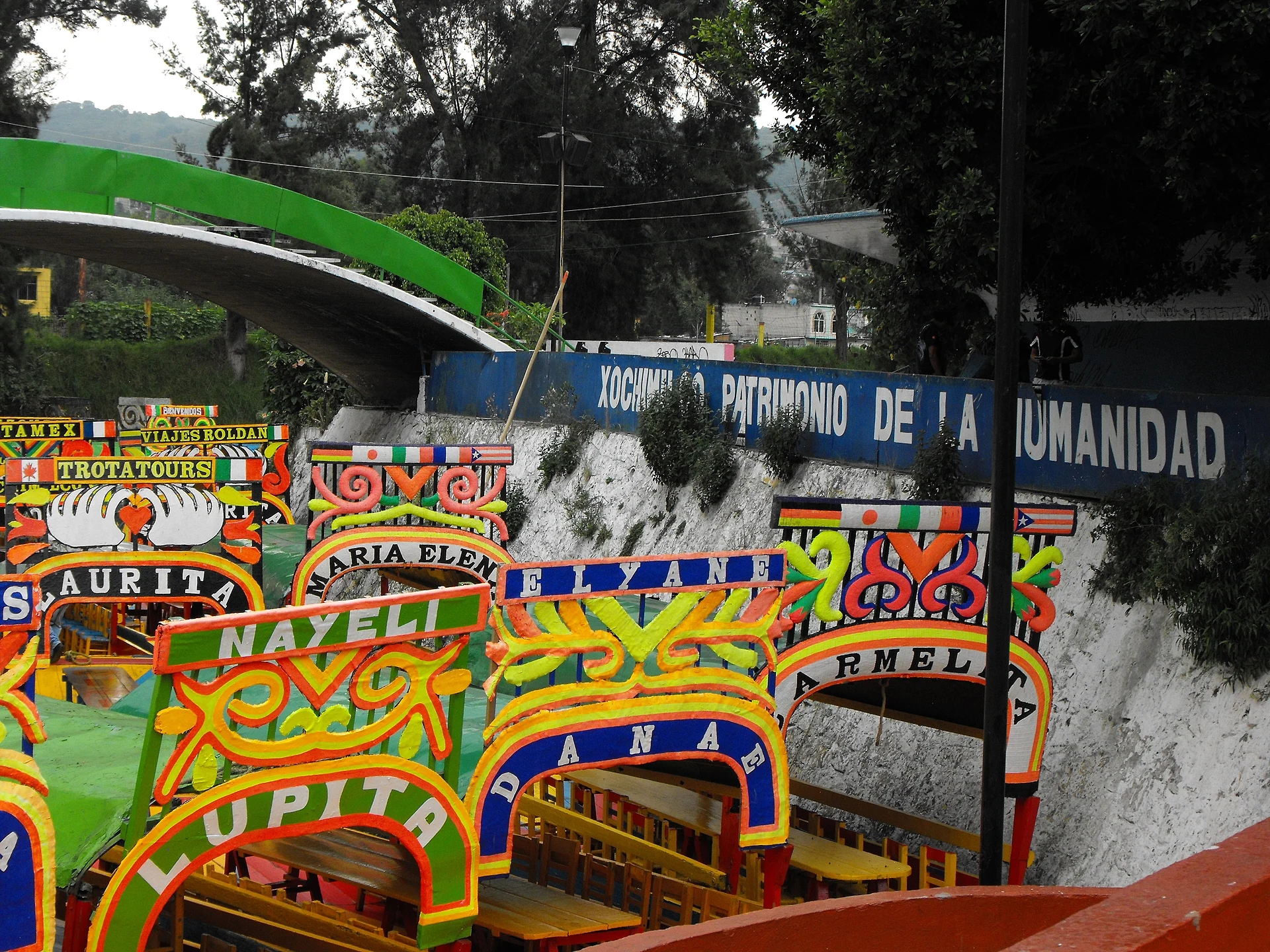
The last of the Aztec lake world: about 170 km of canals and chinampas, a UNESCO site since 1987, toured by painted trajinera at an official 750 pesos an hour.
From Mexico City: 25 min by car (21 km by road) How to get there ↓
Near here


Plan your visit to Xochimilco
Where to stay near Xochimilco
Compare hotels, posadas and guest houses in Xochimilco.
Tours to Xochimilco
Day trips around Tepoztlán sometimes stop in Xochimilco; a tour is the easy way to see it without a car.
 Xochimilco, Coyoacan and Frida Kahlo with Optional Lunch
★ 4.5 (8,395) · From US$40
How to get to Xochimilco
- From Mexico City: about 25 min by road (~21 km)
- Nearest airport: Mexico City (MEX), 1 h 25 min by car to Tepoztlán
Links open a partner site. We may earn a commission if you book, at no cost to you.
Popular tours to Xochimilco


Tours, prices and ratings from Viator, checked weekly. We may earn a commission if you book.
About Xochimilco
Xochimilco, in the far south of Mexico City, is what remains of the great lake system that once filled the Valley of Mexico. Its Nahuatl name means flower field, a nod to the crops and flowers grown on its chinampas, the artificial garden plots that pre-Hispanic farmers built up from the lake bed and that are still worked today. The Xochimilca founded their town here long before the Mexica; Tenochtitlan conquered it in 1430, and Cortés's forces took it on 16 April 1521. The Franciscans then built the church and convent of San Bernardino de Siena, still the heart of the old town. In 1987 the canals and chinampas were inscribed on UNESCO's World Heritage List together with the historic centre of Mexico City.
About 170 km of canals survive, and the classic way to see them is aboard a trajinera, a brightly painted, flat-bottomed boat that the boatman pushes along with a long pole, a little like a gondola. Xochimilco has ten embarcaderos, eight in the tourist zone and two in the ecological reserve; Nativitas, Zacapa and Las Flores in the centre are the busiest, and Cuemanco to the north is the gateway to the quieter reserve canals. Both Nativitas and Cuemanco were remodelled in 2026. The borough sets a single official fare for every authorised embarcadero, 750 pesos an hour for the whole boat, not per person, with up to 18 passengers; pay only at the official ticket booth.
On a weekend the main canals are a floating party, with mariachis and other musicians, and boats pulling alongside to sell food and drinks, all paid for separately; canoes and kayaks can be rented too. Further out, on the reserve side, the water turns calm between chinampas still farmed with flowers and vegetables. The canals' best-known resident is the axolotl, a salamander now very rare in the wild. Back on land, the Mercado de Xochimilco serves cheap food, the Parque Ecológico de Xochimilco has 189 hectares of lakes and paths, and every spring the town crowns La Flor más Bella del Ejido, a contest held here since 1955.
How to get to Xochimilco
Drive from Mexico City: 25 min, 21 km
Take Metro Line 2 to the Tasqueña terminus and change to the Tren Ligero (light rail), which takes the same Metro card; ride it to the end of the line at Xochimilco station, in the centre of the old town near the main embarcaderos. For Cuemanco, get off the Tren Ligero at Periférico station and take a microbús east along the Periférico, or use Metrobús Line 5 to Circuito Cuemanco; the embarcadero is by the Olympic rowing course on Periférico Sur.
Directions to Xochimilco on Google Maps
Distances are in a straight line; the road is usually longer.
Links open a partner site. We may earn a commission if you book, at no cost to you.
From the nearest cities to Xochimilco
- Mexico City · 21 km by road, 25 min
- Cuernavaca · 64 km by road, 1 h 10 min
- Toluca · 73 km by road, 1 h 15 min
Drive times by road from OpenStreetMap, without traffic or stops. Times marked ~ are estimated from the straight-line distance.
What to see in Xochimilco 3
Sights with their own page, closest to the centre first.
Islands
-
Isla de las Muñecas · Island · 2 km from the centre
A chinampa deep in Xochimilco's canals hung with over a thousand weathered dolls, the life's work of a hermit; about 90 minutes by trajinera from Cuemanco.
Landmarks and museums
-
Museo Dolores Olmedo · Landmark · 2 km from the centre
Reopened in May 2026: the largest collection of Rivera and Kahlo in a 16th-century Xochimilco hacienda, with peacocks and hairless dogs in the gardens.
Archaeological sites
-
Cuahilama · Archaeological site · 4 km from the centre
Hill with 15th-century petroglyphs in Santa Cruz Acalpixca, Xochimilco: free entry, a half-hour climb and views over the canals.
Map of Xochimilco
Neighbourhoods and villages of Xochimilco
Part of Xochimilco or just outside it, closest first.
-
San Gregorio Atlapulco · Town · 4 km from the centre
Xochimilco's farming town below Teuhtli volcano: chinampas still worked, a patron-saint fiesta on 12 March and marigold fields for Day of the Dead.
Day trips and tours from Xochimilco
The closest Pueblos Mágicos and places to visit, with the drive from Xochimilco and tours that leave from it.



Times marked ~ are estimated from the distance. Links open a partner site. We may earn a commission if you book, at no cost to you.
Before you go: getting to and around Xochimilco
- The nearest airport is Mexico City (MEX).
- The best months to go are January, February, March, and December.
- 2 of the places on this page are more than 3 km from the centre: take a taxi, a ride-hailing app or a local bus.
- Isla de las Muñecas: reached by boat or on foot, not by road (each page says from where).
- For day trips a rental car gives the most freedom; the tours above leave from Xochimilco.
Before you go to Xochimilco: hours, prices and tips
- Hours
- At Nativitas, boats go out Monday to Friday 8 am to 7 pm and on weekends 8 am to 9 pm. Wikivoyage · checked Oct 2026
- Entry
- The official fare, set by the borough for every authorised embarcadero, is 750 pesos per hour for the whole trajinera (up to 18 people), not per person. Music, food and drinks from other boats are paid separately. Infobae (Alcaldía Xochimilco) · checked Oct 2026
- Time needed
- One hour on the canals is usually enough, whatever the boatmen suggest. Wikivoyage · checked Oct 2026
- Best season
- La Flor más Bella del Ejido is held in April, and the Feria de la Nieve in March or April. Wikivoyage · checked Oct 2026
- Guide or tour
- To go out on the canals you hire a trajinera, which comes with its boatman, at an authorised embarcadero. Tours: Viator GetYourGuide Adondeviajar.mx · checked Oct 2026
- What to bring
- Bring cash, ideally in exact change, and something extra to tip the boatman at the end. Wikivoyage · checked Oct 2026
- Rules
- Pay only at the official ticket booth, never to touts in the street or the parking lot. Under the 2022 rules: at most one bottle of liquor per boat or three beers per adult, stay seated, keep hands inside, no hopping between boats, no loud speakers, and anyone refusing a life jacket signs a waiver. Infobae · checked Oct 2026
Hours and prices change, especially around holidays. Each fact links to where we checked it.
Visiting Xochimilco: what to see and do
Hire a trajinera at an official embarcadero such as Nativitas and spend an hour or more on the canals.
Hire a mariachi from a passing boat and buy food and drinks from the floating vendors.
Take the longer route from Cuemanco into the quieter canals and chinampas of the ecological reserve.
Rent a canoe or kayak to explore at your own pace.
Visit the 16th-century church of San Bernardino de Siena in the old town.
Eat at the Mercado de Xochimilco.
Walk or paddle around the Parque Ecológico de Xochimilco.
Come in spring for La Flor más Bella del Ejido.
Plan your trip
Places to stay in Xochimilco
Compare hotels, posadas, and rentals in and around Xochimilco.
Tours & activities
Day trips around Tepoztlán sometimes stop in Xochimilco; a tour is the easy way to see it without a car.
Rental cars
Pick up a car at MEX (Mexico City): about 1 h 25 min by road to Tepoztlán, then 31 km more to Xochimilco, on your own schedule.
Flights
The nearest airport with scheduled flights is Mexico City (MEX), about 1 h 25 min by road from Tepoztlán, the base for Xochimilco.
Mobile data
Signal can drop away from Tepoztlán: download a map of the way to Xochimilco before you set out, or carry an eSIM with data.
Links open a partner site. We may earn a commission if you book, at no cost to you.
When to go to Xochimilco mild
Xochimilco shares the climate of Tepoztlán, 31 km away. The best months to visit are January, February, March, and December.
See the month-by-month climate of Tepoztlán
Weather in Xochimilco now and the next 7 days
Live forecast from Open-Meteo. Chance of rain is the day's highest.
The closest Pueblo Mágico: Tepoztlán

Tepoztlán is the Pueblo Mágico closest to Xochimilco, with places to stay, food, and more to see.
Also close to
- Tlayacapan · Morelos · 37 km away
- Metepec · Estado de México · 52 km away
- Tepotzotlán · Estado de México · 52 km away
- Malinalco · Estado de México · 54 km away
- Teotihuacán · Estado de México · 55 km away
Near Xochimilco
-
Parque nacional Fuentes Brotantes de Tlalpan · Nature reserve · Ciudad de México
20 min drive · 11 km


Drive times by road from OpenStreetMap, without traffic. Times marked ~ are estimated from the straight-line distance.
Location from OpenStreetMap. Written by Puebloteca.