Town Chalco, Estado de México Municipality of Chalco Valley of Mexico
Town in Chalco about 5 km from the centre, with an 18th-century church, a 1609 viceregal map and a tamale fair every December.
From Mexico City: 45 min by car (45 km by road) How to get there ↓
Near here
See everything nearby ↓


Plan your visit to San Pablo Atlazalpan
Where to stay near San Pablo Atlazalpan
Compare hotels, posadas and guest houses in San Pablo Atlazalpan.
Tours to San Pablo Atlazalpan
Day trips around Tlayacapan sometimes stop in San Pablo Atlazalpan; a tour is the easy way to see it without a car.
 Tours from Mexico City
Teotihuacan pyramids morning or afternoon without tourist traps
★ 4.9 (10,269) · From US$59
How to get to San Pablo Atlazalpan
- From Mexico City: about 45 min by road (~45 km)
- Nearest airport: Mexico City (MEX), 1 h 33 min by car to Tlayacapan
Links open a partner site. We may earn a commission if you book, at no cost to you.
Tours from Mexico City, near San Pablo Atlazalpan


Tours, prices and ratings from Viator, checked weekly. We may earn a commission if you book.
About San Pablo Atlazalpan
San Pablo Atlazalpan is one of the twelve towns of Chalco municipality, east of Mixquic and about 5 km south of the centre of Chalco de Díaz Covarrubias, a little above 2,240 m. In Nahuatl the name is read as "over the waterfall". INEGI counted 18,751 people in 2020, up from 11,236 ten years earlier, so what used to be a farming village now feels like part of the urban belt around Mexico City.
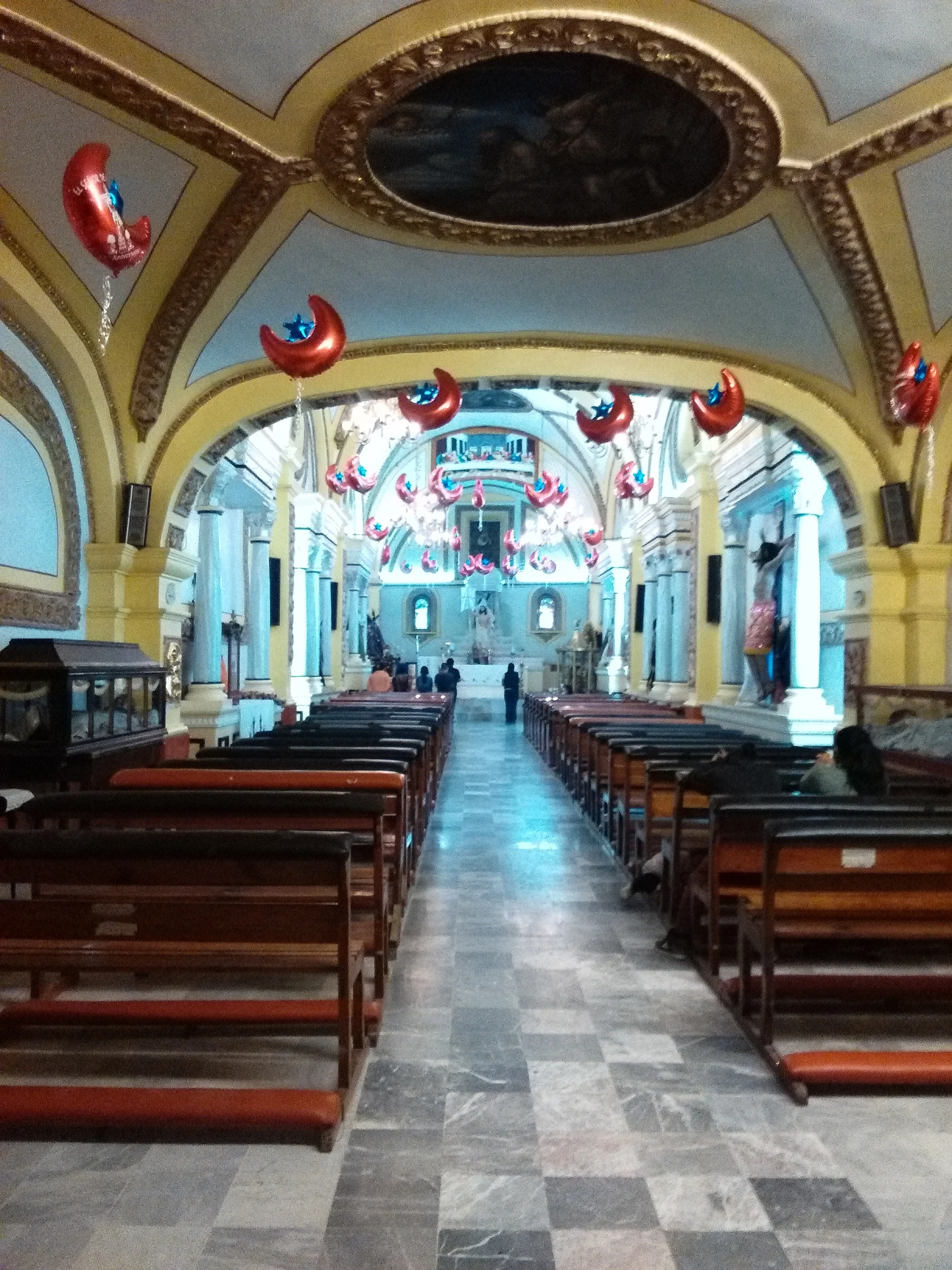
The oldest thing to see is the church of St Peter and St Paul, from the 18th century, its interior restored in 1982. Inside hangs a map of the town authorised by Viceroy Luis de Velasco in 1609. A cloister stands beside the church, and the facade of the Reforma cemetery dates from August 1906. The former Axalco hacienda is also within the town; nobody knows when it was built.
For decades the town carried a religious split. After a traditionalist priest arrived in 1979 the community divided into two camps and public works stalled; in August 2004 state police entered the main church on a court order and handed it to the reform group. The traditionalists opened a church of their own in 2011 and the two now live side by side without conflict, according to Wikipedia.
The big date is 29 June, the feast of the patron saints. In December a week-long Tamale Fair lets local cooks compete for the prize for best tamal and sell to visitors from around the region.
How to get to San Pablo Atlazalpan
Drive from Mexico City: 45 min, 45 km
Atlazalpan is in the south-east of the State of Mexico, about 5 km south of Chalco de Díaz Covarrubias in a straight line and east of San Andrés Mixquic, which belongs to Mexico City's Tláhuac borough. From Mexico City the simplest way by car is the Mexico-Puebla toll road to Chalco, then south through the municipality's streets; allow 40 minutes to an hour, about, depending on traffic. By public transport, Metro Line A ends at La Paz (CETRAM La Paz), from where local transport continues to Chalco; in Chalco you need another ride to Atlazalpan, and it is worth asking for the right stop since routes change.
Directions to San Pablo Atlazalpan on Google Maps
Distances are in a straight line; the road is usually longer.
Links open a partner site. We may earn a commission if you book, at no cost to you.
From the nearest cities to San Pablo Atlazalpan
- Mexico City · 45 km by road, 45 min
- Cuautla · 63 km by road, 1 h 5 min
- San Martín Texmelucan · 70 km by road, 1 h 5 min
Drive times by road from OpenStreetMap, without traffic or stops. Times marked ~ are estimated from the straight-line distance.
Before you go to San Pablo Atlazalpan: hours, prices and tips
- Best time of day
- The patron-saint feast is on 29 June (St Peter and St Paul); in December a week-long Tamale Fair includes a contest among tamale makers. Wikipedia (en) · checked Oct 2026
Hours and prices change, especially around holidays. Each fact links to where we checked it.
Visiting San Pablo Atlazalpan: what to see and do
The church of St Peter and St Paul (18th century), with the 1609 viceregal map inside.
The cloister beside the church.
The Reforma cemetery and its 1906 facade.
The town's central plaza.
The former Axalco hacienda.
The Tamale Fair, one week in December, with a contest among the tamale makers.
Plan your trip
Places to stay in San Pablo Atlazalpan
Compare hotels, posadas, and rentals in and around San Pablo Atlazalpan.
Tours & activities
Day trips around Tlayacapan sometimes stop in San Pablo Atlazalpan; a tour is the easy way to see it without a car.
Rental cars
Pick up a car at MEX (Mexico City): about 1 h 33 min by road to Tlayacapan, then 30 km more to San Pablo Atlazalpan, on your own schedule.
Flights
The nearest airport with scheduled flights is Mexico City (MEX), about 1 h 33 min by road from Tlayacapan, the base for San Pablo Atlazalpan.
Mobile data
Signal can drop away from Tlayacapan: download a map of the way to San Pablo Atlazalpan before you set out, or carry an eSIM with data.
Links open a partner site. We may earn a commission if you book, at no cost to you.
When to go to San Pablo Atlazalpan mild
San Pablo Atlazalpan shares the climate of Tlayacapan, 30 km away. The best months to visit are January, February, March, and December.
See the month-by-month climate of Tlayacapan
Weather in San Pablo Atlazalpan now and the next 7 days
Live forecast from Open-Meteo. Chance of rain is the day's highest.
The closest Pueblo Mágico: Tlayacapan

Tlayacapan is the Pueblo Mágico closest to San Pablo Atlazalpan, with places to stay, food, and more to see.
Also close to
- Tepoztlán · Morelos · 33 km away
- Teotihuacán · Estado de México · 53 km away
- Huejotzingo · Puebla · 53 km away
- Otumba · Estado de México · 56 km away
- Atlixco · Puebla · 61 km away
Closest to San Pablo Atlazalpan
-
Chalco de Díaz Covarrubias · City · 5 km away
-
Cocotitlán · Town · 5 km away
-
Cerro Xico · Mountain · 6 km away
-
San Andrés Metla · Village · 7 km away
-
San Gregorio Cuautzingo · Village · 7 km away
-
Tenango del Aire · Town · 8 km away
-
Xico · City · 8 km away
-
San Antonio Tecómitl · Village · 9 km away


Near San Pablo Atlazalpan


Drive times by road from OpenStreetMap, without traffic. Times marked ~ are estimated from the straight-line distance.
Location from OpenStreetMap. Written by Puebloteca.