Village Chalco, Estado de México Municipality of Chalco Valley of Mexico
Pueblo 4 km east of Chalco's centre with a stone parish church and a brief past as its own municipality (1875-1894).
From Mexico City: 45 min by car (42 km by road) How to get there ↓
Near here
See everything nearby ↓


Plan your visit to San Gregorio Cuautzingo
Where to stay near San Gregorio Cuautzingo
Compare hotels, posadas and guest houses in San Gregorio Cuautzingo.
Tours to San Gregorio Cuautzingo
Day trips and guided outings from Tlayacapan often include San Gregorio Cuautzingo; with a local guide you can get there without a car.
 Tours from Mexico City
Teotihuacan pyramids morning or afternoon without tourist traps
★ 4.9 (10,269) · From US$59
How to get to San Gregorio Cuautzingo
- From Mexico City: about 45 min by road (~42 km)
- Nearest airport: Mexico City (MEX), 1 h 33 min by car to Tlayacapan
Links open a partner site. We may earn a commission if you book, at no cost to you.
Tours from Mexico City, near San Gregorio Cuautzingo


Tours, prices and ratings from Viator, checked weekly. We may earn a commission if you book.
About San Gregorio Cuautzingo
San Gregorio Cuautzingo lies about 4 km east of the centre of Chalco de Díaz Covarrubias, at 2,254 m above sea level. INEGI counted 8,485 people here in 2020, a number that stands out against the 13,138 of 2010: over those ten years the inhabited homes fell from roughly 5,460 to roughly 2,130, and the sources I checked do not explain why. Right beside it, to the east and south, the housing estates of Los Álamos and Los Héroes Chalco have grown up with tens of thousands of residents, so the old village now sits in a ring of new development.
The name is Nahuatl and can be read two ways: "place of the eaglets" or "place of the venerable eagles" (cuauhtli, eagle; tzin, a respectful ending; co, place). San Gregorio is the patron saint, Gregory the Great. Its administrative past is unusual for a village this size: on 16 April 1875 it was made an independent municipality, split from Chalco, but the arrangement lasted under twenty years. On 7 September 1894 the municipality was abolished and the land went back to Chalco.
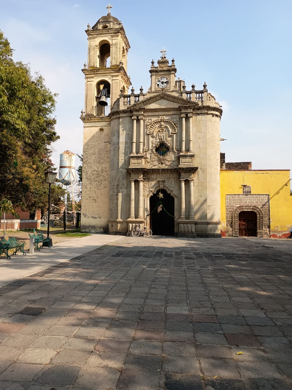
What there is to see is modest: a stone parish church with a bell tower and clock facing a cobbled plaza, and a park with a bandstand, both photographed and drawn by local residents in a Wikimedia Commons documentation project. The climate is temperate highland: about 16 °C on average, January the coolest month, rain on about 250 days a year (July is the wettest) and the occasional winter frost.
How to get to San Gregorio Cuautzingo
Drive from Mexico City: 45 min, 42 km
The village is about 35 km in a straight line from central Mexico City, roughly 40 minutes to an hour and a half by car depending on traffic. The main road toward Chalco is the Mexico–Puebla toll highway, which runs along the Ixtapaluca boundary; from there you reach the centre of Chalco de Díaz Covarrubias and continue about 4 km east on local streets to Cuautzingo.
There is no published published public transport route to Cuautzingo; the practical way is to get to central Chalco and ask there for a combi, or take a taxi for the last stretch. No hotels are registered in the village; the nearest are in Chalco. The closest pueblo on the list is Tlayacapan (Morelos), about 36 km as the crow flies.
Directions to San Gregorio Cuautzingo on Google Maps
Distances are in a straight line; the road is usually longer.
Links open a partner site. We may earn a commission if you book, at no cost to you.
From the nearest cities to San Gregorio Cuautzingo
- Mexico City · 42 km by road, 45 min
- Cuautla · 62 km by road, 1 h
- San Martín Texmelucan · 65 km by road, 1 h
Drive times by road from OpenStreetMap, without traffic or stops. Times marked ~ are estimated from the straight-line distance.
Visiting San Gregorio Cuautzingo: what to see and do
The stone parish church of San Gregorio, with its bell tower and clock, and the cobbled plaza in front.
The park and its bandstand in the middle of the village.
The contrast with the Los Álamos and Los Héroes Chalco housing estates, 1.4-1.8 km away.
The centre of Chalco de Díaz Covarrubias, about 4 km to the west.
Plan your trip
Places to stay in San Gregorio Cuautzingo
Compare hotels, posadas, and rentals in and around San Gregorio Cuautzingo.
Tours & activities
Day trips and guided outings from Tlayacapan often include San Gregorio Cuautzingo; with a local guide you can get there without a car.
Rental cars
Pick up a car at MEX (Mexico City): about 1 h 33 min by road to Tlayacapan, then 36 km more to San Gregorio Cuautzingo, on your own schedule.
Flights
The nearest airport with scheduled flights is Mexico City (MEX), about 1 h 33 min by road from Tlayacapan, the base for San Gregorio Cuautzingo.
Mobile data
Signal can drop away from Tlayacapan: download a map of the way to San Gregorio Cuautzingo before you set out, or carry an eSIM with data.
Links open a partner site. We may earn a commission if you book, at no cost to you.
When to go to San Gregorio Cuautzingo mild
San Gregorio Cuautzingo shares the climate of Tlayacapan, 36 km away. The best months to visit are January, February, March, and December.
See the month-by-month climate of Tlayacapan
Weather in San Gregorio Cuautzingo now and the next 7 days
Live forecast from Open-Meteo. Chance of rain is the day's highest.
The closest Pueblo Mágico: Tlayacapan

Tlayacapan is the Pueblo Mágico closest to San Gregorio Cuautzingo, with places to stay, food, and more to see.
Also close to
- Tepoztlán · Morelos · 40 km away
- Teotihuacán · Estado de México · 48 km away
- Huejotzingo · Puebla · 49 km away
- Otumba · Estado de México · 50 km away
- Atlixco · Puebla · 59 km away
Closest to San Gregorio Cuautzingo
-
Cocotitlán · Town · 3 km away
-
Chalco de Díaz Covarrubias · City · 4 km away
-
San Andrés Metla · Village · 5 km away
-
Ixtapaluca · City · 7 km away
-
San Pablo Atlazalpan · Town · 7 km away
-
Acozac · Archaeological site · 8 km away
-
Cerro Xico · Mountain · 8 km away
-
Tlalmanalco de Velázquez · Town · 8 km away


Near San Gregorio Cuautzingo


Drive times by road from OpenStreetMap, without traffic. Times marked ~ are estimated from the straight-line distance.
Location from OpenStreetMap. Written by Puebloteca.