
Town Tepetitla de Lardizábal, Tlaxcala Municipality of Tepetitla de Lardizábal Volcano Route Monasteries on the slopes of Popocatépetl Puebla Valley
Locality in Tepetitla de Lardizábal with the former San Pedro Rojano hacienda and an April fair for the Señor de la Era.
From San Martín Texmelucan: 5 min by car (4 km by road) How to get there ↓
Near here


Plan your visit to Villa Alta
Where to stay near Villa Alta
Compare hotels, posadas and guest houses in Villa Alta.
Tours to Villa Alta
Day trips around Huejotzingo sometimes stop in Villa Alta; a tour is the easy way to see it without a car.
 Tours from Puebla City
Africam Safari Zoo Admission with Transportation
★ 4.8 (87) · From US$35
How to get to Villa Alta
- From San Martín Texmelucan: about 5 min by road (~4 km)
- Nearest airport: Puebla (PBC), 7 min by car to Huejotzingo
Links open a partner site. We may earn a commission if you book, at no cost to you.
Tours from Puebla City, near Villa Alta


Tours, prices and ratings from Viator, checked weekly. We may earn a commission if you book.
About Villa Alta
Villa Alta is a locality in the municipality of Tepetitla de Lardizábal, in western Tlaxcala, at about 2,240 metres above sea level. It lies 4.5 km from the municipal seat, Tepetitla, and 24 km from Tlaxcala city. At the 2020 census it had 7,756 inhabitants, up from 5,974 in 2010.
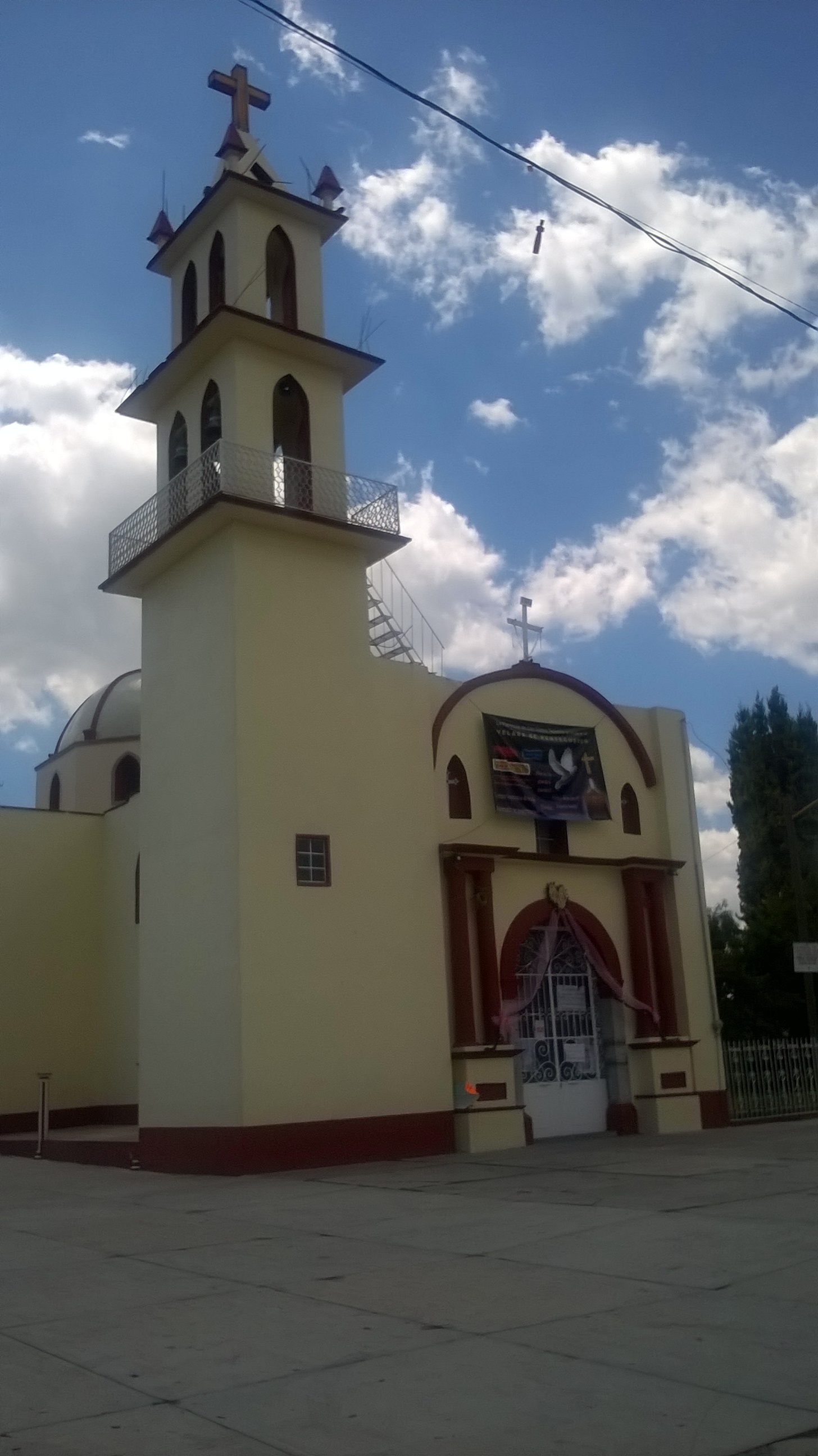
Its church is dedicated to the Divino Salvador: cream-coloured with reddish trim, a three-tier bell tower with a wrought-iron balcony, and a small dome beside the nave. A local news item from 2017 says the church was built in the late 19th and early 20th centuries. The village is also home to the former San Pedro Rojano hacienda, which the municipal monuments catalogue describes as an 18th-century main house with whitewashed facades and stone-and-adobe walls, now split into two private properties.
The village fiesta is not the Divino Salvador's but the Señor de la Era's: a fair committee and a mayordomía organise a fair that in 2017 ran from 21 April to 7 May with the main day on 30 April, and in 2023 was announced for 21 to 29 April. For 2026 the fair committee asked the town hall for support for a programme with a queen pageant, a jaripeo rodeo, a marathon, a cycling race and the greased-pole and greased-pig contests. In the municipality people work with cane (carrizo) and make rockets and castillo fireworks, and the area lies on the Cacaxtla and Xochitécatl tourist route.
How to get to Villa Alta
Drive from San Martín Texmelucan: 5 min, 4 km
Villa Alta is about 24 km from Tlaxcala city and 4.5 km from Tepetitla de Lardizábal. The municipality is reached by highway 119 (Tlaxcala–Tepetitla–San Martín Texmelucan), about 25 km from the state capital, and from Tepetitla you take the local road to Villa Alta. From Puebla it is about 35 km and 40 minutes by car, and Huejotzingo is about 15 km away. From Mexico City the usual way is to reach San Martín Texmelucan or Puebla (CAPU terminal) and continue by road to Tepetitla. During fair days the main accesses can be blocked by protests or by the event, and there are no published schedules for direct public transport to the village.
Directions to Villa Alta on Google Maps
Distances are in a straight line; the road is usually longer.
Links open a partner site. We may earn a commission if you book, at no cost to you.
From the nearest cities to Villa Alta
- San Martín Texmelucan · 4 km by road, 5 min
- Chiautempan · 32 km by road, 25 min
- Puebla · 43 km by road, 40 min
Drive times by road from OpenStreetMap, without traffic or stops. Times marked ~ are estimated from the straight-line distance.
What to see in Villa Alta 1
Sights with their own page, closest to the centre first.
-
Exconvento de Santa María Magdalena · Landmark · 4 km from the centre
Baroque Dieguino convent in central San Martín Texmelucan, a national monument since 1933, with Churrigueresque altarpieces and a 1794 German organ.
Map of Villa Alta
Neighbourhoods and villages of Villa Alta
Part of Villa Alta or just outside it, closest first.
-
San Mateo Ayecac · Village · 1 km from the centre
Locality of Tepetitla on the Atoyac river, with a 19th-century church of San Mateo and a fiesta on 21 September. -
San Gabriel Popocatla · Village · 3 km from the centre
Ixtacuixtla village in western Tlaxcala, known for papier-mâché workshops that build catrinas up to 4 m tall, alebrijes and piñatas. -
Tepetitla de Lardizábal · Town · 4 km from the centre
A seat beside San Martín Texmelucan, with the church of San Mateo (fiesta 21 September), reed work and fireworks.
Day trips and tours from Villa Alta
The closest Pueblos Mágicos and places to visit, with the drive from Villa Alta and tours that leave from it.


Times marked ~ are estimated from the distance. Links open a partner site. We may earn a commission if you book, at no cost to you.
Before you go: getting to and around Villa Alta
- The nearest airport is Puebla (PBC).
- The best months to go are January, February, March, and November.
- 2 of the places on this page are more than 3 km from the centre: take a taxi, a ride-hailing app or a local bus.
- For day trips a rental car gives the most freedom; the tours above leave from Villa Alta.
Before you go to Villa Alta: hours, prices and tips
- Best season
- Fair of the Señor de la Era in late April (in 2017, 21 April to 7 May with the main day on 30 April; in 2023, 21 to 29 April). e-Tlaxcala / Escenario Tlaxcala · checked Oct 2026
Hours and prices change, especially around holidays. Each fact links to where we checked it.
Visiting Villa Alta: what to see and do
Divino Salvador church, with its three-tier tower and wrought-iron balcony
Former San Pedro Rojano hacienda, an 18th-century main house
Fair of the Señor de la Era in late April, main day 30 April
San Mateo church in Tepetitla, 19th century, 4.5 km away
The Cacaxtla and Xochitécatl route, on which the municipality lies
Plan your trip
Places to stay in Villa Alta
Compare hotels, posadas, and rentals in and around Villa Alta.
Tours & activities
Day trips around Huejotzingo sometimes stop in Villa Alta; a tour is the easy way to see it without a car.
Rental cars
Pick up a car at PBC (Puebla): about 7 min by road to Huejotzingo, then 15 km more to Villa Alta, on your own schedule.
Flights
The nearest airport with scheduled flights is Puebla (PBC), about 7 min by road from Huejotzingo, the base for Villa Alta.
Mobile data
Signal can drop away from Huejotzingo: download a map of the way to Villa Alta before you set out, or carry an eSIM with data.
Links open a partner site. We may earn a commission if you book, at no cost to you.
When to go to Villa Alta mild
Villa Alta shares the climate of Huejotzingo, 15 km away. The best months to visit are January, February, March, and November.
See the month-by-month climate of Huejotzingo
Weather in Villa Alta now and the next 7 days
Live forecast from Open-Meteo. Chance of rain is the day's highest.
The closest Pueblo Mágico: Huejotzingo

Huejotzingo is the Pueblo Mágico closest to Villa Alta, with places to stay, food, and more to see.
Also close to
Near Villa Alta




Drive times by road from OpenStreetMap, without traffic. Times marked ~ are estimated from the straight-line distance.
Location from OpenStreetMap. Written by Puebloteca.