Town Tepetitla de Lardizábal, Tlaxcala Municipality of Tepetitla de Lardizábal Volcano Route Monasteries on the slopes of Popocatépetl Puebla Valley
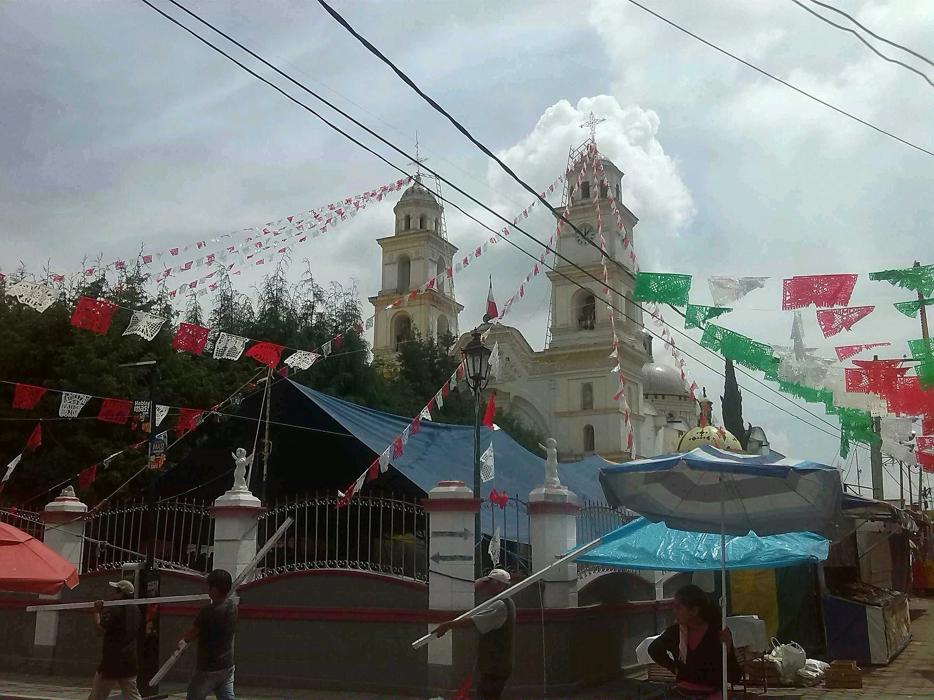
A seat beside San Martín Texmelucan, with the church of San Mateo (fiesta 21 September), reed work and fireworks.
From San Martín Texmelucan: 10 min by car (9 km by road) How to get there ↓
Near here


Plan your visit to Tepetitla de Lardizábal
Where to stay near Tepetitla de Lardizábal
Compare hotels, posadas and guest houses in Tepetitla de Lardizábal.
Tours to Tepetitla de Lardizábal
Day trips around Huejotzingo sometimes stop in Tepetitla de Lardizábal; a tour is the easy way to see it without a car.
 Tours from Puebla City
Africam Safari Zoo Admission with Transportation
★ 4.8 (87) · From US$35
How to get to Tepetitla de Lardizábal
- From San Martín Texmelucan: about 10 min by road (~9 km)
- Nearest airport: Puebla (PBC), 7 min by car to Huejotzingo
Links open a partner site. We may earn a commission if you book, at no cost to you.
Tours from Puebla City, near Tepetitla de Lardizábal


Tours, prices and ratings from Viator, checked weekly. We may earn a commission if you book.
About Tepetitla de Lardizábal
Tepetitla de Lardizábal is the seat of the municipality of the same name, in southwest Tlaxcala and right on the Puebla border, within the Puebla-Tlaxcala metropolitan zone. It lies at about 2,224 metres above sea level and had 9,606 inhabitants at the 2020 census. In pre-Hispanic times this strip was a kind of no-man's-land between the lordships of Tlaxcala and those of Cholula and Huejotzingo; by 1626 a village called Tepetitlan already appears, and the decree making it a municipality dates from 1880 under Governor Miguel Lira y Ortega.
The 19th-century church of San Mateo has a Latin-cross plan, two towers and a presbytery with a gilded ciprés altar. Its fiesta is on 21 September: if that falls midweek it moves to the following Sunday, and the main day starts at 4 a.m. with Las Mañanitas, rockets and bells and ends at night with fireworks. Locals work reed and, above all, pyrotechnics: rockets, castillos, toritos, wheels and balloons.
Carnival brings a single camada of catrines and paragüeros: men in suits, hats and canes, women carrying umbrellas. The closing event is in front of the municipal hall, with a contest among invited camadas. Nearby are San Mateo Ayecac, the church of San Salvador and the ex-haciendas San Pedro Rojano and San Carlos.
How to get to Tepetitla de Lardizábal
Drive from San Martín Texmelucan: 10 min, 9 km
Tepetitla de Lardizábal is 25 km from Tlaxcala city on highway 119 Tlaxcala-Tepetitla-San Martín, according to INAFED, and sits on the Cacaxtla-Xochitécatl route. From Puebla it is about 31 km and 35 minutes, and to Huejotzingo about 12 km and 15 minutes. The municipality borders San Martín Texmelucan, Puebla, to the west, so it can also be reached from that side. For public transport, start from the Tlaxcala bus terminal, the CAPU in Puebla or San Martín Texmelucan; there are no published lines or schedules.
Directions to Tepetitla de Lardizábal on Google Maps
Distances are in a straight line; the road is usually longer.
Links open a partner site. We may earn a commission if you book, at no cost to you.
From the nearest cities to Tepetitla de Lardizábal
- San Martín Texmelucan · 9 km by road, 10 min
- Chiautempan · 29 km by road, 30 min
- Puebla · 35 km by road, 40 min
Drive times by road from OpenStreetMap, without traffic or stops. Times marked ~ are estimated from the straight-line distance.
What to see in Tepetitla de Lardizábal 1
Sights with their own page, closest to the centre first.
-
Xochitécatl · Archaeological site · 4 km from the centre
A ceremonial centre begun about 800 BC on an extinct volcano's summit, with the Pyramid of the Flowers and the round Spiral Building, facing Cacaxtla.
Map of Tepetitla de Lardizábal
Neighbourhoods and villages of Tepetitla de Lardizábal
Part of Tepetitla de Lardizábal or just outside it, closest first.
-
San Mateo Ayecac · Village · 3 km from the centre
Locality of Tepetitla on the Atoyac river, with a 19th-century church of San Mateo and a fiesta on 21 September. -
San Miguel Xochitecatitla · Village · 4 km from the centre
Village of 2,199 people at the foot of the Xochitécatl archaeological zone, with a parish church to Saint Michael the Archangel. -
Santa Inés Tecuexcomac · Town · 4 km from the centre
Ixtacuixtla locality of 3,079 people, with the church of Santa Inés on the Tlaxcala-San Martín road and a farming economy. -
Santa María Moyotzingo · Village · 4 km from the centre
Large town south of Texmelucan with a Preclassic pyramid base, the tepematzin, that looks like a little hill in the middle of town. -
Villa Alta · Town · 4 km from the centre
Locality in Tepetitla de Lardizábal with the former San Pedro Rojano hacienda and an April fair for the Señor de la Era.
Day trips and tours from Tepetitla de Lardizábal
The closest Pueblos Mágicos and places to visit, with the drive from Tepetitla de Lardizábal and tours that leave from it.


Times marked ~ are estimated from the distance. Links open a partner site. We may earn a commission if you book, at no cost to you.
Before you go: getting to and around Tepetitla de Lardizábal
- The nearest airport is Puebla (PBC).
- The best months to go are January, February, March, and November.
- 5 of the places on this page are more than 3 km from the centre: take a taxi, a ride-hailing app or a local bus.
- For day trips a rental car gives the most freedom; the tours above leave from Tepetitla de Lardizábal.
Before you go to Tepetitla de Lardizábal: hours, prices and tips
- Best season
- San Mateo fiesta on 21 September (moved to the following Sunday if midweek); carnival of catrines and paragüeros in February or March, closing on a Tuesday. INAFED, Enciclopedia de los Municipios: Tepetitla de Lardizábal · checked Oct 2026
Hours and prices change, especially around holidays. Each fact links to where we checked it.
Visiting Tepetitla de Lardizábal: what to see and do
The 19th-century church of San Mateo with its gilded ciprés.
The San Mateo fiesta on 21 September, with Mañanitas at 4 a.m. and fireworks.
The carnival of catrines and paragüeros, closing in front of the municipal hall.
The church of San Salvador, from the 19th and 20th centuries.
The ex-haciendas San Pedro Rojano and San Carlos.
The church of San Mateo Ayecac, on the plaza of the neighbouring locality.
Plan your trip
Places to stay in Tepetitla de Lardizábal
Compare hotels, posadas, and rentals in and around Tepetitla de Lardizábal.
Tours & activities
Day trips around Huejotzingo sometimes stop in Tepetitla de Lardizábal; a tour is the easy way to see it without a car.
Rental cars
Pick up a car at PBC (Puebla): about 7 min by road to Huejotzingo, then 12 km more to Tepetitla de Lardizábal, on your own schedule.
Flights
The nearest airport with scheduled flights is Puebla (PBC), about 7 min by road from Huejotzingo, the base for Tepetitla de Lardizábal.
Mobile data
Signal can drop away from Huejotzingo: download a map of the way to Tepetitla de Lardizábal before you set out, or carry an eSIM with data.
Links open a partner site. We may earn a commission if you book, at no cost to you.
When to go to Tepetitla de Lardizábal mild
Tepetitla de Lardizábal shares the climate of Huejotzingo, 12 km away. The best months to visit are January, February, March, and November.
See the month-by-month climate of Huejotzingo
Weather in Tepetitla de Lardizábal now and the next 7 days
Live forecast from Open-Meteo. Chance of rain is the day's highest.
The closest Pueblo Mágico: Huejotzingo

Huejotzingo is the Pueblo Mágico closest to Tepetitla de Lardizábal, with places to stay, food, and more to see.
Also close to
Near Tepetitla de Lardizábal


Drive times by road from OpenStreetMap, without traffic. Times marked ~ are estimated from the straight-line distance.
Location from OpenStreetMap. Written by Puebloteca.