Archaeological site Natívitas, Tlaxcala Municipality of Natívitas Volcano Route Monasteries on the slopes of Popocatépetl Puebla Valley
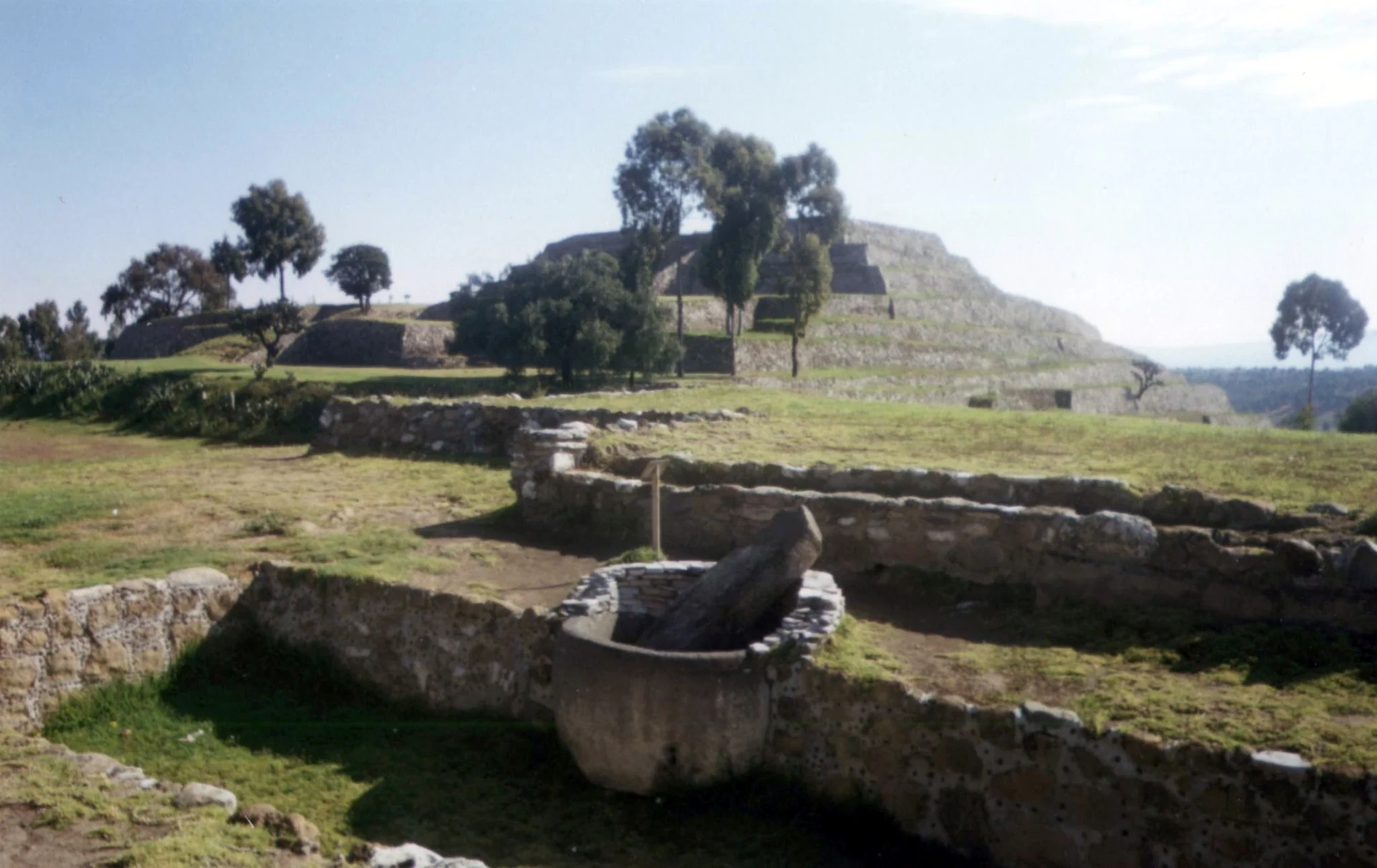
A ceremonial centre begun about 800 BC on an extinct volcano's summit, with the Pyramid of the Flowers and the round Spiral Building, facing Cacaxtla.
From San Martín Texmelucan: 15 min by car (14 km by road) How to get there ↓
Near here
See everything nearby ↓


Plan your visit to Xochitécatl
Where to stay near Xochitécatl
Compare hotels, posadas and guest houses in Xochitécatl.
Tours to Xochitécatl
A guide brings Xochitécatl to life: look for tours from Huejotzingo that include the site and the ride there.
 Tours from Puebla City
Africam Safari Zoo Admission with Transportation
★ 4.8 (87) · From US$35
How to get to Xochitécatl
- From San Martín Texmelucan: about 15 min by road (~14 km)
- Nearest airport: Puebla (PBC), 7 min by car to Huejotzingo
Links open a partner site. We may earn a commission if you book, at no cost to you.
Tours from Puebla City, near Xochitécatl


Tours, prices and ratings from Viator, checked weekly. We may earn a commission if you book.
About Xochitécatl
Xochitécatl is an archaeological zone on the summit of the hill of the same name, an extinct volcano rising about 200 metres above the Puebla-Tlaxcala valley in the municipality of Natívitas, southwest of Tlaxcala city. Its buildings cover about 12 hectares of the hilltop between the Atoyac and Zahuapan rivers, and from the plaza you can see Popocatépetl and Iztaccíhuatl to the west and La Malinche to the east. The Nahuatl name joins xōchitl, flower, and tecatl, person, roughly "lineage of flowers". INAH runs it as one zone with Cacaxtla, the city of the murals, which stands on the neighbouring hill in plain view.
Building began around 800 BC, in the Middle Preclassic, with the Pyramid of the Flowers, the Serpent Building and the Spiral Building. Between about 350 BC and AD 100 it was the seat of a chiefdom that controlled much of western Tlaxcala, and it was above all a ceremonial centre rather than a city: people lived spread out on terraces of houses and fields on the slopes. An eruption of Popocatépetl around the first century and the years after it led to its abandonment. Between AD 600 and 950 the Olmeca-Xicalanca of Cacaxtla reoccupied it as a secondary ritual centre and built the Platform of the Volcanoes; then both sites were left empty, although the hill was still used for rituals.
The Pyramid of the Flowers is the largest building, with a base of roughly 100 by 140 metres, close in size to the Pyramid of the Moon at Teotihuacan. More than 30 burials were found in it, almost all of children, and the offerings on its stairway held thousands of clay figurines showing women at every stage of life: girls, pregnant women, mothers with children and old women. This is why archaeologists link the site to a fertility and rain cult. The pyramid faces La Malinche, and every 29 September the sun rises directly over the volcano as seen from its summit. Two large monolithic basins stand in front of the stairway; the bigger one held stone sculptures of a toad, a serpent and two human faces. The Spiral Building is a round pyramid with no staircase, climbed by following its spiral, and is thought to have been a temple to Ehécatl, the wind god; a cross was set on its top in 1632 and is still there. The Serpent Building keeps a basin with a stela carved with fangs and a forked tongue. The main excavations, led by Mari Carmen Serra Puche, took place between 1992 and 1994, and the site opened to the public in 1994. A site museum displays finds from the hill, including many of the figurines.
How to get to Xochitécatl
Drive from San Martín Texmelucan: 15 min, 14 km
By car from Mexico City, take federal highway 150 or the 150D toll road toward Puebla as far as San Martín Texmelucan, in Puebla; from there follow the road to Xalmimilulco toward San Miguel Xochitecatitla, where signs point to Xochitécatl and Cacaxtla. Another way in is the highway 150 exit for San Rafael Tenanyecac (km 99), then on through San Miguel del Milagro. It takes about 90 minutes from Mexico City and about 30 minutes from Tlaxcala city, some 18 km away.
By public transport: Estrella Roja (Super Rápidos) buses leave Mexico City's TAPO terminal for San Martín Texmelucan every few minutes and take about 2 hours, and from Puebla's CAPU the Super Rápidos reach San Martín in about 50 minutes; from San Martín a taxi to the site takes about 10 minutes. The site museum is in the community of San Miguel Xochitecatitla, at the foot of the hill.
Directions to Xochitécatl on Google Maps
Distances are in a straight line; the road is usually longer.
Links open a partner site. We may earn a commission if you book, at no cost to you.
From the nearest cities to Xochitécatl
- San Martín Texmelucan · 14 km by road, 15 min
- Chiautempan · 27 km by road, 30 min
- Puebla · 35 km by road, 40 min
Drive times by road from OpenStreetMap, without traffic or stops. Times marked ~ are estimated from the straight-line distance.
Before you go to Xochitécatl: hours, prices and tips
- Hours
- Archaeological zone: Monday to Sunday, 9 am to 5 pm, last entry 4 pm. Site museum: Wednesday to Sunday, 10 am to 5 pm. INAH · checked Oct 2026
- Entry
- Mexican visitors MX$105, foreign visitors MX$210 (covers Cacaxtla and the site museum). Free on Sundays for Mexicans, and for Mexican children under 13, students, teachers and seniors with ID. INAH · checked Oct 2026
- Rules
- No smoking, food, pets or flash photography. INAH · checked Oct 2026
Hours and prices change, especially around holidays. Each fact links to where we checked it.
Visiting Xochitécatl: what to see and do
Climb the Pyramid of the Flowers and take in the volcanoes from the top; on 29 September the sun rises over La Malinche.
Look for the two monolithic basins in front of its stairway.
Walk around the Spiral Building, the round pyramid crowned by the 1632 cross.
See the basin and serpent stela on the Serpent Building.
See the female figurines in the site museum (Wednesday to Sunday).
Cross to Cacaxtla on the neighbouring hill on the same ticket.
Plan your trip
Places to stay in Xochitécatl
Compare hotels, posadas, and rentals in and around Xochitécatl.
Tours & activities
A guide brings Xochitécatl to life: look for tours from Huejotzingo that include the site and the ride there.
Rental cars
Pick up a car at PBC (Puebla): about 7 min by road to Huejotzingo, then 11 km more to Xochitécatl, on your own schedule.
Flights
The nearest airport with scheduled flights is Puebla (PBC), about 7 min by road from Huejotzingo, the base for Xochitécatl.
Mobile data
Signal can drop away from Huejotzingo: download a map of the way to Xochitécatl before you set out, or carry an eSIM with data.
Links open a partner site. We may earn a commission if you book, at no cost to you.
When to go to Xochitécatl mild
Xochitécatl shares the climate of Huejotzingo, 11 km away. The best months to visit are January, February, March, and November.
See the month-by-month climate of Huejotzingo
Weather in Xochitécatl now and the next 7 days
Live forecast from Open-Meteo. Chance of rain is the day's highest.
The closest Pueblo Mágico: Huejotzingo

Huejotzingo is the Pueblo Mágico closest to Xochitécatl, with places to stay, food, and more to see.
Also close to
Closest to Xochitécatl
-
Cacaxtla-Xochitécatl · Archaeological site · 1 km away
-
San Miguel Xochitecatitla · Village · 1 km away
-
San Bernabé Capula · Village · 2 km away
-
Santuario de San Miguel del Milagro · Landmark · 2 km away
-
Santiago Michac · Town · 3 km away
-
Jesús Tepactepec · Village · 4 km away
-
Natívitas · Village · 4 km away
-
Santa Apolonia Teacalco · Town · 4 km away


Near Xochitécatl



Drive times by road from OpenStreetMap, without traffic. Times marked ~ are estimated from the straight-line distance.
Lists with Xochitécatl
Ruins in Tlaxcala · 3 Ruins near San Martín Texmelucan · 13 Ruins near Huejotzingo · 12 Ruins near Chiautempan · 9 Ruins near Puebla · 8 Ruins near Atlixco · 11 Ruins near Huamantla · 8 Ruins near Tlaxco · 9Location from OpenStreetMap. Written by Puebloteca.