Town San Jerónimo Zacualpan, Tlaxcala Volcano Route Monasteries on the slopes of Popocatépetl Puebla Valley
Southern Tlaxcala town with a clock-tower church, tule weaving, carnival charros and a San Jerónimo fiesta on 30 September.
From Chiautempan: 15 min by car (16 km by road) How to get there ↓
Near here


Plan your visit to San Jerónimo Zacualpan
Where to stay near San Jerónimo Zacualpan
Compare hotels, posadas and guest houses in San Jerónimo Zacualpan.
Tours to San Jerónimo Zacualpan
Day trips around Huejotzingo sometimes stop in San Jerónimo Zacualpan; a tour is the easy way to see it without a car.
 Tours from Puebla City
Africam Safari Zoo Admission with Transportation
★ 4.8 (87) · From US$35
How to get to San Jerónimo Zacualpan
- From Chiautempan: about 15 min by road (~16 km)
- Nearest airport: Puebla (PBC), 7 min by car to Huejotzingo
Links open a partner site. We may earn a commission if you book, at no cost to you.
Tours from Puebla City, near San Jerónimo Zacualpan


Tours, prices and ratings from Viator, checked weekly. We may earn a commission if you book.
About San Jerónimo Zacualpan
San Jerónimo Zacualpan is the seat of a tiny municipality in southern Tlaxcala: it has only three localities and 4,092 people at the 2020 census, 4,061 of them in the town itself, at about 2,200 m. It is part of the Puebla-Tlaxcala metropolitan zone. Zacualpan comes from Nahuatl tzacualli and pan, "on the mound" or "on the shrine".
The Enciclopedia de los Municipios places it among the settlements of the Tlatempa culture, with terraced fields and canals, and later as the head of one of the 17 Texcalac-period lordships that formed Tlaxcala. In colonial times its church was a visita of the Tepeyanco convent. Colonel Anastasio Meneses Bonilla was born here on 15 April 1876; he fought alongside Domingo Arenas, reached the Senate and was killed in San Luis Potosí in 1936. The municipality was created by decree on 27 September 1995, split from Tetlatlahuca.
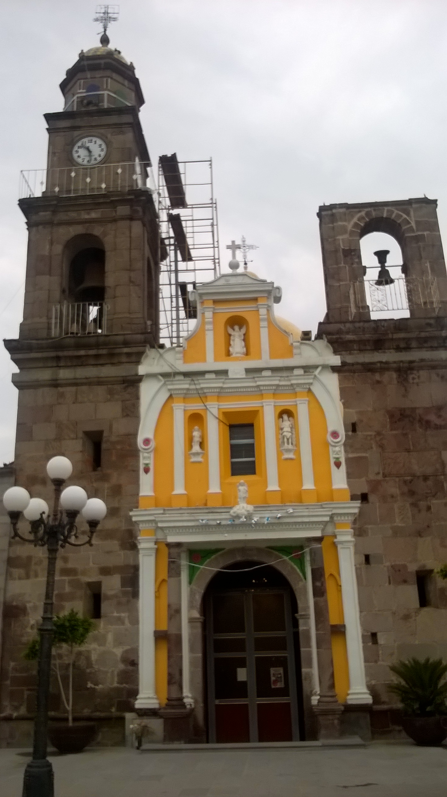
The church of San Jerónimo dates from the 18th and 19th centuries, in cut stone, with a four-stage tower ending in a small dome, a clock on the third stage, a bell gable and, inside, a main altarpiece with the image of the saint. The big fiesta is 30 September, with mass, fireworks and fairground rides. At carnival, troupes of charros appear in carved wooden masks and embroidered velvet costumes, accompanied by a wind orchestra. Residents weave petates, fans, mats and hats from tule; local food includes chicken in adobo and anise tamales, and the fields produce maize, beans and vegetables sold in Mexico City.
How to get to San Jerónimo Zacualpan
Drive from Chiautempan: 15 min, 16 km
San Jerónimo Zacualpan is in southern Tlaxcala on the corridor of the federal highway and the Tlaxcala-San Martín Texmelucan toll road, which the Enciclopedia de los Municipios says passes through the town and connects with Puebla and Mexico City. From Tlaxcala city it is a short drive on that road; from Puebla, about 23 km and 25 minutes. By public transport the simplest way is a bus to Tlaxcala or Zacatelco (from Puebla, CAPU), then a combi or taxi. Huactzinco, the neighbouring town to the south, is a few minutes by road, and Huejotzingo (a Pueblo Mágico in Puebla) is about 18 km away.
Directions to San Jerónimo Zacualpan on Google Maps
Distances are in a straight line; the road is usually longer.
Links open a partner site. We may earn a commission if you book, at no cost to you.
From the nearest cities to San Jerónimo Zacualpan
- Chiautempan · 16 km by road, 15 min
- San Martín Texmelucan · 25 km by road, 25 min
- Puebla · 27 km by road, 30 min
Drive times by road from OpenStreetMap, without traffic or stops. Times marked ~ are estimated from the straight-line distance.
Map of San Jerónimo Zacualpan
Neighbourhoods and villages of San Jerónimo Zacualpan
Part of San Jerónimo Zacualpan or just outside it, closest first.
-
San Juan Huactzinco · Town · 1 km from the centre
Bread-baking town in southern Tlaxcala with a Franciscan church from 1670, carnival costumes and a San Juan Apóstol fiesta on 27 December. -
San Lorenzo Axocomanitla · Town · 2 km from the centre
One of Mexico's smallest municipalities: a 17th-century church, San Lorenzo's fiesta on 10 August and fibre basketry. -
San Andrés Cuamilpa · Village · 3 km from the centre
Tetlatlahuca village whose Nahuatl name means "in the wooded milpa"; church of Saint Andrew the Apostle. -
San Bartolomé Tenango · Village · 3 km from the centre
Village in Tetlatlahuca with a 19th-century church of San Bartolomé, its tower topped by a tiled dome; fiesta on 24 August. -
Tepeyanco · Town · 3 km from the centre
Old lordship south of Tlaxcala city with the ruins of a 1554 Franciscan convent, a brick-and-tile parish church and a name for avocados. -
La Aurora · Village · 4 km from the centre
Tepeyanco locality close to the Franciscan former convent, among avocado orchards with La Malinche in the background. -
San Cosme Atlamaxac · Town · 4 km from the centre
Locality in Tepeyanco, 9 km from Tlaxcala city, with 3,019 residents in 2020, next to the Calvario hill and under 1 km from the municipal seat. -
San Diego Metepec · Town · 4 km from the centre
Town in Tlaxcala municipality, 'hill of the maguey', with a red-and-white church tower and the La Ocotera ecological park. -
Tetlatlahuca · Town · 4 km from the centre
A municipal seat with the parish of Santa Isabel (fiesta 19 November), tule crafts and an ancient settlement on the Cerro de La Cruz. -
Zacatelco · Town · 4 km from the centre
South Tlaxcala town between Puebla and the state capital: the Baroque Santa Inés parish, frothy cacao drink and the chivarrudos carnival dance.


Day trips and tours from San Jerónimo Zacualpan
The closest Pueblos Mágicos and places to visit, with the drive from San Jerónimo Zacualpan and tours that leave from it.


Times marked ~ are estimated from the distance. Links open a partner site. We may earn a commission if you book, at no cost to you.
Before you go: getting to and around San Jerónimo Zacualpan
- The nearest airport is Puebla (PBC).
- The best months to go are January, February, March, and November.
- 5 of the places on this page are more than 3 km from the centre: take a taxi, a ride-hailing app or a local bus.
- For day trips a rental car gives the most freedom; the tours above leave from San Jerónimo Zacualpan.
Before you go to San Jerónimo Zacualpan: hours, prices and tips
- Best season
- Patron fiesta of San Jerónimo on 30 September; carnival with charro troupes. INAFED, Enciclopedia de los Municipios · checked Oct 2026
Hours and prices change, especially around holidays. Each fact links to where we checked it.
Visiting San Jerónimo Zacualpan: what to see and do
The church of San Jerónimo, with its four-stage clock tower
The main altarpiece, with San Jerónimo at the centre
Petates, mats and hats woven from tule
The patron fiesta on 30 September
Carnival charro troupes with carved wooden masks
Plan your trip
Places to stay in San Jerónimo Zacualpan
Compare hotels, posadas, and rentals in and around San Jerónimo Zacualpan.
Tours & activities
Day trips around Huejotzingo sometimes stop in San Jerónimo Zacualpan; a tour is the easy way to see it without a car.
Rental cars
Pick up a car at PBC (Puebla): about 7 min by road to Huejotzingo, then 18 km more to San Jerónimo Zacualpan, on your own schedule.
Flights
The nearest airport with scheduled flights is Puebla (PBC), about 7 min by road from Huejotzingo, the base for San Jerónimo Zacualpan.
Mobile data
Signal can drop away from Huejotzingo: download a map of the way to San Jerónimo Zacualpan before you set out, or carry an eSIM with data.
Links open a partner site. We may earn a commission if you book, at no cost to you.
When to go to San Jerónimo Zacualpan mild
San Jerónimo Zacualpan shares the climate of Huejotzingo, 18 km away. The best months to visit are January, February, March, and November.
See the month-by-month climate of Huejotzingo
Weather in San Jerónimo Zacualpan now and the next 7 days
Live forecast from Open-Meteo. Chance of rain is the day's highest.
The closest Pueblo Mágico: Huejotzingo

Huejotzingo is the Pueblo Mágico closest to San Jerónimo Zacualpan, with places to stay, food, and more to see.
Also close to
Near San Jerónimo Zacualpan


Drive times by road from OpenStreetMap, without traffic. Times marked ~ are estimated from the straight-line distance.
Location from OpenStreetMap. Written by Puebloteca.