
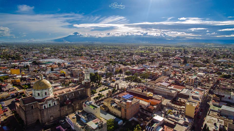
Town Zacatelco, Tlaxcala Puebla Valley
South Tlaxcala town between Puebla and the state capital: the Baroque Santa Inés parish, frothy cacao drink and the chivarrudos carnival dance.
From Chiautempan: 15 min by car (16 km by road) How to get there ↓
Near here


Plan your visit to Zacatelco
Where to stay near Zacatelco
Compare hotels, posadas and guest houses in Zacatelco.
Tours to Zacatelco
Day trips around Cholula sometimes stop in Zacatelco; a tour is the easy way to see it without a car.
 Tours from Puebla City
Africam Safari Zoo Admission with Transportation
★ 4.8 (87) · From US$35
How to get to Zacatelco
- From Chiautempan: about 15 min by road (~16 km)
- Nearest airport: Puebla (PBC), 16 min by car to Cholula
Links open a partner site. We may earn a commission if you book, at no cost to you.
Tours from Puebla City, near Zacatelco


Tours, prices and ratings from Viator, checked weekly. We may earn a commission if you book.
About Zacatelco
Zacatelco is the seat of the municipality of the same name in southern Tlaxcala, on federal highway 119 between Puebla and the state capital. It sits at about 2,210 m, 12 km from Tlaxcala city and some 28 km from Puebla, and is part of the Puebla metropolitan area. The 2020 census counted 45,587 people, making it one of the largest towns in the state; locals are called zacatelquenses. The Nahuatl name is usually read as "on the grass mound or shrine", from zacatl (grass), tlaltetl (mound) and the place suffix co.
People lived here as early as the Tlatempa phase, 1200-800 BC, and the area later fell under the influence of Cholula. When the Spanish arrived it belonged to Ocotelulco, one of the four lordships of the Tlaxcalan republic. The cacique Agustín de Castañeda formally founded the town on 1 December 1529. It was a visiting church of the Franciscan friary at Tepeyanco until 1640, when Bishop Palafox handed parishes to the diocesan clergy and Zacatelco became a parish seat in its own right. During the Revolution the Arenas brothers led the agrarian struggle here; Domingo Arenas set up one of Mexico's first land committees in 1915, and his equestrian statue stands in the central park, opened in 1967.
The standout building is the parish church of Santa Inés, rebuilt in the second half of the 18th century on the site of a 16th-century church. It has a Baroque doorway with acanthus-leaf pilasters, a dome often compared with Puebla Cathedral's and a large carved wooden altarpiece with estípite and Solomonic columns, paintings of archangels and 17th-century statues; a one-piece basalt font from the early 1600s, carved with the Franciscan wounds of Christ, survives near the entrance. The church was damaged in the earthquake of 19 September 2017. Nearby are the Sagrado Corazón church, from the 18th and 19th centuries, and the old station of the Apizaco-Puebla railway, listed by INAH as railway heritage.
Zacatelco's signature is cacao: a drink of cacao with toasted broad beans and sugar, whisked with a wooden molinillo until it foams. The state congress declared it intangible cultural heritage in 2014, and it gets its own Feria del Cacao every October. Bread with ice cream, pan con helado, has been sold here since 1930. At carnival the huehue troupes of the town's sections come out alongside the chivarrudos, a dance recalling hacienda cowhands in goat-hide chaps. Local craftspeople weave willow (huejote) baskets and make rope and wire plant holders.
How to get to Zacatelco
Drive from Chiautempan: 15 min, 16 km
Zacatelco is on federal highway 119 between Puebla and Tlaxcala, 12 km south of Tlaxcala city (about 16 minutes by car) and some 22 km from central Puebla (about 23 minutes). The Bulevar Metropolitano Puebla-Tlaxcala and the Puebla-Zacatelco-Tlaxcala toll road, opened in 2015, also reach it, the latter with an interchange in town. From Mexico City (123 km) come along the Mexico-Puebla motorway; the Texmelucan-Zacatelco road joins the 119. By bus, ATAH and Autobuses Supra run hourly from TAPO to Tlaxcala (about 1 h 30 min); from the Tlaxcala bus station, or from CAPU in Puebla, continue by local bus or taxi down the 119. Cholula, the nearest pueblo mágico, is about 17 km away (around 20 minutes).
Directions to Zacatelco on Google Maps
Distances are in a straight line; the road is usually longer.
Links open a partner site. We may earn a commission if you book, at no cost to you.
From the nearest cities to Zacatelco
- Chiautempan · 16 km by road, 15 min
- Puebla · 22 km by road, 25 min
- San Martín Texmelucan · 29 km by road, 30 min
Drive times by road from OpenStreetMap, without traffic or stops. Times marked ~ are estimated from the straight-line distance.
What to see in Zacatelco 1
Sights with their own page, closest to the centre first.
-
Laguna de Acomulco · Lagoon · 2 km from the centre
A lagoon of about 20,000 m² in Zacatelco's fourth section, fed by springs and under restoration since the 2010s.
Map of Zacatelco
Neighbourhoods and villages of Zacatelco
Part of Zacatelco or just outside it, closest first.
-
San Lorenzo Axocomanitla · Town · 1 km from the centre
One of Mexico's smallest municipalities: a 17th-century church, San Lorenzo's fiesta on 10 August and fibre basketry. -
San Juan Huactzinco · Town · 2 km from the centre
Bread-baking town in southern Tlaxcala with a Franciscan church from 1670, carnival costumes and a San Juan Apóstol fiesta on 27 December. -
Santa Cruz Quilehtla · Town · 2 km from the centre
Seat of a young municipality in southern Tlaxcala: carnival chivarrudos, rockets and paper flowers, and the Holy Cross fiesta on 3 May. -
El Carmen Aztama · Village · 3 km from the centre
Teolocholco village whose Nahuatl name means 'place where herons are hunted', with a Virgen del Carmen church and a fair that starts on 14 July. -
San Cosme Atlamaxac · Town · 3 km from the centre
Locality in Tepeyanco, 9 km from Tlaxcala city, with 3,019 residents in 2020, next to the Calvario hill and under 1 km from the municipal seat. -
Santa Catarina Ayometla · Town · 3 km from the centre
Municipal seat in southern Tlaxcala: 18th-century parish of Santa Catarina, tinsmithing and a patron-saint fiesta on 25 November. -
Tepeyanco · Town · 3 km from the centre
Old lordship south of Tlaxcala city with the ruins of a 1554 Franciscan convent, a brick-and-tile parish church and a name for avocados. -
Acuamanala · Village · 4 km from the centre
A Baroque village on La Malinche's slopes with an 18th-century church, fireworks, mole prieto and a feast on 13 June. -
Concepción Chimalpa · Village · 4 km from the centre
Village in Acuamanala on the slopes of La Malinche, with a plain Immaculate Conception chapel on the Camino Real . -
San Jerónimo Zacualpan · Town · 4 km from the centre
Southern Tlaxcala town with a clock-tower church, tule weaving, carnival charros and a San Jerónimo fiesta on 30 September.


Day trips and tours from Zacatelco
The closest Pueblos Mágicos and places to visit, with the drive from Zacatelco and tours that leave from it.


Times marked ~ are estimated from the distance. Links open a partner site. We may earn a commission if you book, at no cost to you.
Before you go: getting to and around Zacatelco
- The nearest airport is Puebla (PBC).
- The best months to go are January, February, March, and December.
- 3 of the places on this page are more than 3 km from the centre: take a taxi, a ride-hailing app or a local bus.
- For day trips a rental car gives the most freedom; the tours above leave from Zacatelco.
Before you go to Zacatelco: hours, prices and tips
- Best season
- Santa Inés fair 17 January-1 February (main day 21 January); Feria de la Flor 7-16 June in Xochicalco; Feria del Cacao 24-26 October; carnival with huehues and chivarrudos before Lent. Wikipedia (es) · checked Oct 2026
Hours and prices change, especially around holidays. Each fact links to where we checked it.
Visiting Zacatelco: what to see and do
The Santa Inés parish church, with its dome, 18th-century wooden altarpiece and basalt font.
The central park and the equestrian monument to Domingo Arenas.
A cup of frothy cacao and some pan con helado in the centre or at the Ignacio Bonilla market.
The Latin-cross Sagrado Corazón church; in June the Feria de la Flor in Xochicalco honours the Sacred Heart.
The old railway station, listed by INAH as railway heritage.
The Cerrito del Chiquihuite, a small pre-Hispanic mound topped by a chapel.
Plan your trip
Places to stay in Zacatelco
Compare hotels, posadas, and rentals in and around Zacatelco.
Tours & activities
Day trips around Cholula sometimes stop in Zacatelco; a tour is the easy way to see it without a car.
Rental cars
Pick up a car at PBC (Puebla): about 16 min by road to Cholula, then 19 km more to Zacatelco, on your own schedule.
Flights
The nearest airport with scheduled flights is Puebla (PBC), about 16 min by road from Cholula, the base for Zacatelco.
Mobile data
Signal can drop away from Cholula: download a map of the way to Zacatelco before you set out, or carry an eSIM with data.
Links open a partner site. We may earn a commission if you book, at no cost to you.
When to go to Zacatelco mild
Zacatelco shares the climate of Cholula, 19 km away. The best months to visit are January, February, March, and December.
See the month-by-month climate of Cholula
Weather in Zacatelco now and the next 7 days
Live forecast from Open-Meteo. Chance of rain is the day's highest.
The closest Pueblo Mágico: Cholula

Cholula is the Pueblo Mágico closest to Zacatelco, with places to stay, food, and more to see.
Also close to
- Huejotzingo · Puebla · 19 km away
- Ixtenco · Tlaxcala · 32 km away
- Huamantla · Tlaxcala · 35 km away
- Atlixco · Puebla · 39 km away
- Tlaxco · Tlaxcala · 46 km away
Near Zacatelco


Drive times by road from OpenStreetMap, without traffic. Times marked ~ are estimated from the straight-line distance.
Location from OpenStreetMap. Written by Puebloteca.