Town Teolocholco, Tlaxcala Municipality of Teolocholco La Malinche
Municipal seat on the lower slopes of La Malinche, with a Baroque San Luis Obispo parish, a finely carved atrium cross and a walnut fair in August.
From Chiautempan: 10 min by car (9 km by road) How to get there ↓
Near here


Plan your visit to Teolocholco
Where to stay near Teolocholco
Compare hotels, posadas and guest houses in Teolocholco.
Tours to Teolocholco
Day trips around Cholula sometimes stop in Teolocholco; a tour is the easy way to see it without a car.
 Tours from Puebla City
Africam Safari Zoo Admission with Transportation
★ 4.8 (87) · From US$35
How to get to Teolocholco
- From Chiautempan: about 10 min by road (~9 km)
- Nearest airport: Puebla (PBC), 16 min by car to Cholula
Links open a partner site. We may earn a commission if you book, at no cost to you.
Tours from Puebla City, near Teolocholco


Tours, prices and ratings from Viator, checked weekly. We may earn a commission if you book.
About Teolocholco
San Luis Teolocholco is the seat of the municipality of Teolocholco in southern Tlaxcala, about 2,320 metres up on the western slopes of La Malinche. It had 19,147 inhabitants in the 2020 census, and the municipality, which also takes in El Carmen Aztama and Acxotla del Monte, belongs to the Puebla-Tlaxcala metropolitan area. The name comes from Nahuatl teotl, god, and choloa, to flee or go away, with the place suffix co, and is translated as "place where the gods hid or went away".
The Tlaxcala census rolls of 1556-1557 already list San Luis Teolocholco as a village subject to San José Acuitlapilco, which in turn depended on the lordship of Ocotelulco, with 437 households. In colonial times its people shared the land and timber of La Malinche with neighbouring villages, and in 1749-1750 its local nobles, led by Pedro Sánchez Mazahuatzin, fought to avoid being registered as tribute payers. During the Revolution the Tlaxcalan leader Juan Cuamatzi spent the night on the Teolocholco mountain before coming down on 19 November 1910 to cut the railway between Apizaco and Puebla, and in 1914 the town took up arms with General Domingo Arenas. In 1934 Acuamanala, Quilehtla and Ayometitla were split off to form a separate municipality.
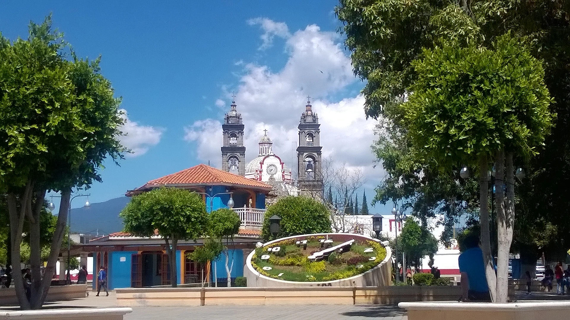
The main building is the parish church of San Luis Obispo, whose two towers rise behind the municipal park with its kiosk and flower clock. Its stone façade is Baroque, probably 17th century, with paired columns, a trefoil entrance arch with Saint Michael on the keystone and, higher up, the double-headed eagle of the Habsburgs. The atrium is small but holds one of the finest atrium crosses in Tlaxcala, covered in low-relief symbols of the Passion, its arms ending in prickly pears; inside are five Baroque altarpieces. A mural in the town hall traces the town's history.
The main festival is San Luis Obispo's: on the night of 18 August mariachis sing the mañanitas, on the 19th thousands of visitors arrive, and on the following Sunday families serve mole with festival bread. The Walnut Fair runs at the same time, with Castile walnuts and meringues sold by the kiosk. At carnival, camadas of huehues dance quadrilles and charros perform the snake dance to a brass band; the Quetzalli camada was founded in 2005. For the Day of the Dead the town has its own custom: on 2 November the families of those who died during the year carry the offering to the grave and stay two or three hours at the cemetery. Local cooking means turkey mole, tlacoyos and preserves of capulín cherry and tejocote, with pulque.
How to get to Teolocholco
Drive from Chiautempan: 10 min, 9 km
From Tlaxcala city it is about 13 km, roughly 16 minutes: leave on federal highway 119 (Tlaxcala-Puebla) toward Chiautempan and south, then turn east up the avenues that climb to Teolocholco (Avenida Malintzi and Avenida Reforma) to the centre. From Puebla it is about 26 km, roughly 27 minutes, on federal highway 121 (Puebla-Belem), which runs past the town. From Mexico City it is about 125 km.
By public transport: ATAH and Supra buses leave Mexico City's TAPO terminal for Tlaxcala every hour (about 1 hr 30 min); from Tlaxcala or Chiautempan continue by local transport or taxi to Teolocholco.
Directions to Teolocholco on Google Maps
Distances are in a straight line; the road is usually longer.
Links open a partner site. We may earn a commission if you book, at no cost to you.
From the nearest cities to Teolocholco
- Chiautempan · 9 km by road, 10 min
- Puebla · 26 km by road, 30 min
- San Martín Texmelucan · 36 km by road, 35 min
Drive times by road from OpenStreetMap, without traffic or stops. Times marked ~ are estimated from the straight-line distance.
Map of Teolocholco
Neighbourhoods and villages of Teolocholco
Part of Teolocholco or just outside it, closest first.
-
Acuamanala · Village · 2 km from the centre
A Baroque village on La Malinche's slopes with an 18th-century church, fireworks, mole prieto and a feast on 13 June. -
Acxotla del Monte · Town · 3 km from the centre
Santa María Acxotla del Monte, a village of Teolocholco on La Malinche's slope, with a Virgen del Pilar church and an October fair. -
Concepción Chimalpa · Village · 3 km from the centre
Village in Acuamanala on the slopes of La Malinche, with a plain Immaculate Conception chapel on the Camino Real . -
El Carmen Aztama · Village · 3 km from the centre
Teolocholco village whose Nahuatl name means 'place where herons are hunted', with a Virgen del Carmen church and a fair that starts on 14 July. -
San Francisco Tetlanohcan · Town · 3 km from the centre
Seat of a municipality at 2,420 m on the slopes of La Malinche: St Francis church with a clock, carnival camadas and woollen textiles. -
Ayometitla · Village · 4 km from the centre
Second-largest locality in the municipality of Santa Cruz Quilehtla, with a chapel of Santiago and 2,158 people in 2020. -
La Aurora · Village · 4 km from the centre
Tepeyanco locality close to the Franciscan former convent, among avocado orchards with La Malinche in the background. -
La Magdalena Tlaltelulco · Town · 4 km from the centre
A town on the lower slopes of La Malinche, 8 km from Tlaxcala on the Chiautempan-Puebla road, its own municipality since 1995, with a barrio carnival. -
San Cosme Atlamaxac · Town · 4 km from the centre
Locality in Tepeyanco, 9 km from Tlaxcala city, with 3,019 residents in 2020, next to the Calvario hill and under 1 km from the municipal seat. -
Santa Isabel Xiloxoxtla · Town · 4 km from the centre
Seat of one of Tlaxcala's smallest municipalities, with an industrial park, a charros carnival and the chapel of Juan Diego. -
Santiago Tlacochcalco · Village · 4 km from the centre
Village in Tepeyanco on the Acuitlapilco lagoon, with a church of Santiago Apóstol and a patron-saint fiesta on 25 July.


Day trips and tours from Teolocholco
The closest Pueblos Mágicos and places to visit, with the drive from Teolocholco and tours that leave from it.


Times marked ~ are estimated from the distance. Links open a partner site. We may earn a commission if you book, at no cost to you.
Before you go: getting to and around Teolocholco
- The nearest airport is Puebla (PBC).
- The best months to go are January, February, March, and December.
- 6 of the places on this page are more than 3 km from the centre: take a taxi, a ride-hailing app or a local bus.
- For day trips a rental car gives the most freedom; the tours above leave from Teolocholco.
Before you go to Teolocholco: hours, prices and tips
- Best season
- San Luis Obispo festival and Walnut Fair: mañanitas on the night of 18 August, main day on the 19th and a mole meal the following Sunday. Carnival with camadas of huehues before Lent. Day of the Dead: offerings at the cemetery on 2 November. Wikipedia (Municipio de Teolocholco) · checked Oct 2026
Hours and prices change, especially around holidays. Each fact links to where we checked it.
Visiting Teolocholco: what to see and do
The Baroque façade of the San Luis Obispo parish church and its five altarpieces.
The atrium cross carved with symbols of the Passion, its arms ending in prickly pears.
The municipal park with its kiosk and flower clock, La Malinche behind it.
The history mural in the town hall.
The San Luis festival and Walnut Fair on 18 and 19 August.
Plan your trip
Places to stay in Teolocholco
Compare hotels, posadas, and rentals in and around Teolocholco.
Tours & activities
Day trips around Cholula sometimes stop in Teolocholco; a tour is the easy way to see it without a car.
Rental cars
Pick up a car at PBC (Puebla): about 16 min by road to Cholula, then 24 km more to Teolocholco, on your own schedule.
Flights
The nearest airport with scheduled flights is Puebla (PBC), about 16 min by road from Cholula, the base for Teolocholco.
Mobile data
Signal can drop away from Cholula: download a map of the way to Teolocholco before you set out, or carry an eSIM with data.
Links open a partner site. We may earn a commission if you book, at no cost to you.
When to go to Teolocholco mild
Teolocholco shares the climate of Cholula, 24 km away. The best months to visit are January, February, March, and December.
See the month-by-month climate of Cholula
Weather in Teolocholco now and the next 7 days
Live forecast from Open-Meteo. Chance of rain is the day's highest.
The closest Pueblo Mágico: Cholula

Cholula is the Pueblo Mágico closest to Teolocholco, with places to stay, food, and more to see.
Also close to
- Huejotzingo · Puebla · 25 km away
- Ixtenco · Tlaxcala · 27 km away
- Huamantla · Tlaxcala · 29 km away
- Tlaxco · Tlaxcala · 42 km away
- Atlixco · Puebla · 44 km away
Near Teolocholco


Drive times by road from OpenStreetMap, without traffic. Times marked ~ are estimated from the straight-line distance.
Location from OpenStreetMap. Written by Puebloteca.