
Village Santa Cruz Quilehtla, Tlaxcala Puebla Valley La Malinche
Second-largest locality in the municipality of Santa Cruz Quilehtla, with a chapel of Santiago and 2,158 people in 2020.
From Chiautempan: 15 min by car (13 km by road) How to get there ↓
Near here
See everything nearby ↓


Plan your visit to Ayometitla
Where to stay near Ayometitla
Compare hotels, posadas and guest houses in Ayometitla.
Tours to Ayometitla
Day trips and guided outings from Cholula often include Ayometitla; with a local guide you can get there without a car.
 Tours from Puebla City
Africam Safari Zoo Admission with Transportation
★ 4.8 (87) · From US$35
How to get to Ayometitla
- From Chiautempan: about 15 min by road (~13 km)
- Nearest airport: Puebla (PBC), 16 min by car to Cholula
Links open a partner site. We may earn a commission if you book, at no cost to you.
Tours from Puebla City, near Ayometitla


Tours, prices and ratings from Viator, checked weekly. We may earn a commission if you book.
About Ayometitla
Ayometitla is a locality in the municipality of Santa Cruz Quilehtla, in southern Tlaxcala, at about 2,324 metres above sea level. Its name comes from Nahuatl and is interpreted as in the aqueduct of the maguey. At the 2020 census it had 2,158 residents; in 2010 there were 1,841 and in 1921 only 259, making it the second-largest locality in the municipality after the seat, Santa Cruz Quilehtla, about 3 km to the north.
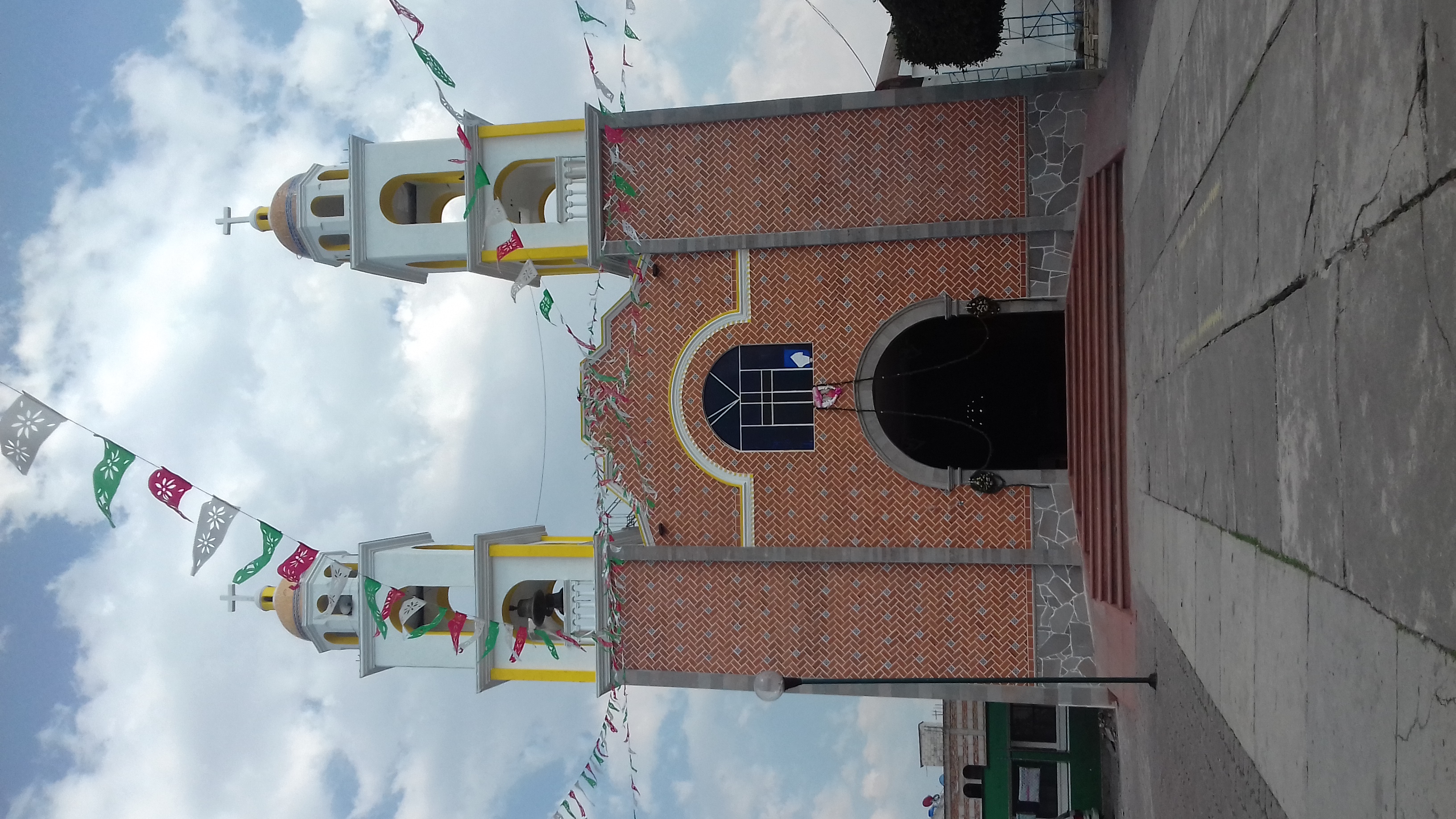
The most visible building is the chapel of Santiago, with a reddish brick facade and two white-and-yellow towers topped with tiled domes. The municipality it belongs to is one of the last created in Tlaxcala: a decree of the State Congress on 11 August 1995 separated it from Acuamanala de Miguel Hidalgo. It borders Tepeyanco, Santa Catarina Ayometla, Acuamanala and Zacatelco.
Life in the area is that of farming villages and trades. The municipality makes paper flowers and fireworks such as rockets, castillos, toritos and cascadas, and in the kitchen mole prieto, handmade white or blue maize tortillas, tamales, tlatlapas and pulque stand out. Very close are Olextla de Juárez (half a kilometre away), Concepción Chimalpa, San Marcos Contla and Mazatecochco, with which Ayometitla shares fields and lanes.
How to get to Ayometitla
Drive from Chiautempan: 15 min, 13 km
Ayometitla is in southern Tlaxcala, about 3 km from Santa Cruz Quilehtla, the municipal seat, and less than a kilometre from Olextla de Juárez. According to Pueblos de América, San Pedro Cholula (Puebla) is about 33 minutes by car and Huejotzingo about 37; Huamantla about 50 minutes. There are no published bus lines or colectivos to the village, so the most practical way is by car or to ask about local transport in Zacatelco or Santa Cruz Quilehtla. Distances are approximate.
Directions to Ayometitla on Google Maps
Distances are in a straight line; the road is usually longer.
Links open a partner site. We may earn a commission if you book, at no cost to you.
From the nearest cities to Ayometitla
- Chiautempan · 13 km by road, 15 min
- Puebla · 21 km by road, 25 min
- San Martín Texmelucan · 35 km by road, 35 min
Drive times by road from OpenStreetMap, without traffic or stops. Times marked ~ are estimated from the straight-line distance.
Visiting Ayometitla: what to see and do
Chapel of Santiago, with a brick facade and two towers with tiled domes.
Chapel of the Sacred Heart in Santa Cruz Quilehtla, 19th century, about 3 km away.
Paper-flower and fireworks workshops of the municipality.
Mole prieto, tlatlapas and pulque in the area's kitchens.
Plan your trip
Places to stay in Ayometitla
Compare hotels, posadas, and rentals in and around Ayometitla.
Tours & activities
Day trips and guided outings from Cholula often include Ayometitla; with a local guide you can get there without a car.
Rental cars
Pick up a car at PBC (Puebla): about 16 min by road to Cholula, then 20 km more to Ayometitla, on your own schedule.
Flights
The nearest airport with scheduled flights is Puebla (PBC), about 16 min by road from Cholula, the base for Ayometitla.
Mobile data
Signal can drop away from Cholula: download a map of the way to Ayometitla before you set out, or carry an eSIM with data.
Links open a partner site. We may earn a commission if you book, at no cost to you.
When to go to Ayometitla mild
Ayometitla shares the climate of Cholula, 20 km away. The best months to visit are January, February, March, and December.
See the month-by-month climate of Cholula
Weather in Ayometitla now and the next 7 days
Live forecast from Open-Meteo. Chance of rain is the day's highest.
The closest Pueblo Mágico: Cholula

Cholula is the Pueblo Mágico closest to Ayometitla, with places to stay, food, and more to see.
Also close to
- Huejotzingo · Puebla · 23 km away
- Ixtenco · Tlaxcala · 28 km away
- Huamantla · Tlaxcala · 31 km away
- Atlixco · Puebla · 41 km away
- Tlaxco · Tlaxcala · 46 km away
Closest to Ayometitla
-
Concepción Chimalpa · Village · 1 km away
-
Acuamanala · Village · 2 km away
-
Santa Catarina Ayometla · Town · 2 km away
-
Mazatecochco · Town · 3 km away
-
Santa Cruz Quilehtla · Town · 3 km away
-
El Carmen Aztama · Village · 4 km away
-
Papalotla · Town · 4 km away
-
San Marcos Contla · Town · 4 km away


Near Ayometitla


Drive times by road from OpenStreetMap, without traffic. Times marked ~ are estimated from the straight-line distance.
Location from OpenStreetMap. Written by Puebloteca.