
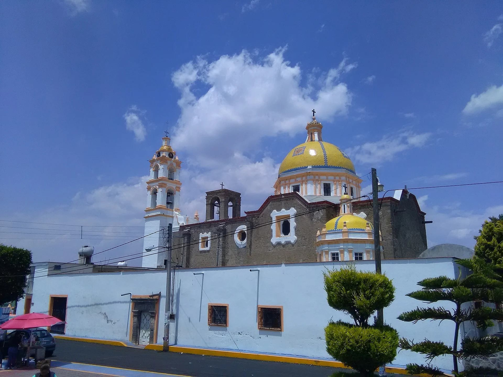
Village Acuamanala de Miguel Hidalgo, Tlaxcala La Malinche
A Baroque village on La Malinche's slopes with an 18th-century church, fireworks, mole prieto and a feast on 13 June.
From Chiautempan: 10 min by car (11 km by road) How to get there ↓
Near here
See everything nearby ↓


Plan your visit to Acuamanala
Where to stay near Acuamanala
Compare hotels, posadas and guest houses in Acuamanala.
Tours to Acuamanala
Day trips and guided outings from Cholula often include Acuamanala; with a local guide you can get there without a car.
 Tours from Puebla City
Africam Safari Zoo Admission with Transportation
★ 4.8 (87) · From US$35
How to get to Acuamanala
- From Chiautempan: about 10 min by road (~11 km)
- Nearest airport: Puebla (PBC), 16 min by car to Cholula
Links open a partner site. We may earn a commission if you book, at no cost to you.
Tours from Puebla City, near Acuamanala


Tours, prices and ratings from Viator, checked weekly. We may earn a commission if you book.
About Acuamanala
Acuamanala is the seat of the municipality of Acuamanala de Miguel Hidalgo, on the slopes of La Malinche in southern Tlaxcala, within the Puebla metropolitan zone. It sits at about 2,300 metres and at the 2020 census the locality had 1,911 inhabitants; the whole municipality totals 6,432, shared with Concepción Chimalpa, Guadalupe Hidalgo and Olextla. According to Wikipedia the name comes from Nahuatl and means vessel or place of good water storage. The municipality has no permanent rivers, only seasonal streams.
The main sight is the parish of San Antonio de Padua, from the 18th century, built with river stone and with a white lime-plaster facade picked out in yellow, a barrel vault and a tiled dome. The atrium keeps its pinnacled wall and a stone cross dated 1602. Inside are Baroque and neoclassical altarpieces and an original organ. In Ayometitla stands the Señor Santiago chapel, and in La Concepción Chimalpa the Concepción chapel on the Camino Real; of the Rancho Espíritu Santo, from the 18th and 19th centuries, adobe and stone ruins remain.
The main feast is 13 June for San Antonio de Padua, and on 17 January San Antonio Abad is celebrated. At carnival charros and chivarrudos dance in velvet costumes and carved wooden masks. Artisans make rockets, castillos, toritos and balloons, and the kitchen is known for mole prieto with blue and white tortillas, tlatlapas, pulque and pipián. The municipality is part of the Tlaxcala and its Señoríos route, built around Cacaxtla-Xochitécatl.
How to get to Acuamanala
Drive from Chiautempan: 10 min, 11 km
Acuamanala is about 20 km from Puebla (roughly 25 minutes by car, approx.) and about 22 km from Cholula. It lies on the slopes of La Malinche in southern Tlaxcala, surrounded by Teolocholco, San Pablo del Monte, Papalotla de Xicohténcatl, Santa Cruz Quilehtla, Mazatecochco and Tepeyanco. The practical route is a bus to Puebla's CAPU (from TAPO in Mexico City) or to Tlaxcala's bus station, with buses between them about every 15 minutes (Autobuses Valles, about 40 minutes), then a taxi or local colectivo. There are no published colectivo routes or schedules to Acuamanala and no clear highway number for the last stretch, so confirm at the terminal or with the town hall (Monday to Friday, 9:00 to 17:00).
Directions to Acuamanala on Google Maps
Distances are in a straight line; the road is usually longer.
Links open a partner site. We may earn a commission if you book, at no cost to you.
From the nearest cities to Acuamanala
- Chiautempan · 11 km by road, 10 min
- Puebla · 24 km by road, 25 min
- San Martín Texmelucan · 38 km by road, 35 min
Drive times by road from OpenStreetMap, without traffic or stops. Times marked ~ are estimated from the straight-line distance.
Before you go to Acuamanala: hours, prices and tips
- Best season
- San Antonio Abad on 17 January; San Antonio de Padua on 13 June; carnival with charros and chivarrudos. Municipio de Acuamanala · checked Oct 2026
Hours and prices change, especially around holidays. Each fact links to where we checked it.
Visiting Acuamanala: what to see and do
Go into the 18th-century parish of San Antonio de Padua and see its facade and original organ.
Find the 1602 stone cross in the atrium.
Visit the Concepción chapel on the Camino Real in La Concepción Chimalpa.
See the Señor Santiago chapel in Ayometitla.
Look at the ruins of Rancho Espíritu Santo.
Come on 13 June or at carnival and try the mole prieto.
Plan your trip
Places to stay in Acuamanala
Compare hotels, posadas, and rentals in and around Acuamanala.
Tours & activities
Day trips and guided outings from Cholula often include Acuamanala; with a local guide you can get there without a car.
Rental cars
Pick up a car at PBC (Puebla): about 16 min by road to Cholula, then 22 km more to Acuamanala, on your own schedule.
Flights
The nearest airport with scheduled flights is Puebla (PBC), about 16 min by road from Cholula, the base for Acuamanala.
Mobile data
Signal can drop away from Cholula: download a map of the way to Acuamanala before you set out, or carry an eSIM with data.
Links open a partner site. We may earn a commission if you book, at no cost to you.
When to go to Acuamanala mild
Acuamanala shares the climate of Cholula, 22 km away. The best months to visit are January, February, March, and December.
See the month-by-month climate of Cholula
Weather in Acuamanala now and the next 7 days
Live forecast from Open-Meteo. Chance of rain is the day's highest.
The closest Pueblo Mágico: Cholula

Cholula is the Pueblo Mágico closest to Acuamanala, with places to stay, food, and more to see.
Also close to
- Huejotzingo · Puebla · 23 km away
- Ixtenco · Tlaxcala · 28 km away
- Huamantla · Tlaxcala · 31 km away
- Atlixco · Puebla · 42 km away
- Tlaxco · Tlaxcala · 44 km away
Closest to Acuamanala
-
Concepción Chimalpa · Village · 1 km away
-
Ayometitla · Village · 2 km away
-
El Carmen Aztama · Village · 2 km away
-
Teolocholco · Town · 2 km away
-
San Cosme Atlamaxac · Town · 3 km away
-
Santa Catarina Ayometla · Town · 3 km away
-
Santa Cruz Quilehtla · Town · 3 km away
-
La Aurora · Village · 4 km away


Near Acuamanala


Drive times by road from OpenStreetMap, without traffic. Times marked ~ are estimated from the straight-line distance.
Location from OpenStreetMap. Written by Puebloteca.