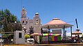

Town Tenancingo, Tlaxcala Puebla Valley
A town in southern Tlaxcala next to Puebla, with the San Miguel parish and a carnival of toreros and charros.
From Puebla: 15 min by car (14 km by road) How to get there ↓
Near here


Plan your visit to Tenancingo
Where to stay near Tenancingo
Compare hotels, posadas and guest houses in Tenancingo.
Tours to Tenancingo
Day trips around Cholula sometimes stop in Tenancingo; a tour is the easy way to see it without a car.
How to get to Tenancingo
- From Puebla: about 15 min by road (~14 km)
- Nearest airport: Puebla (PBC), 16 min by car to Cholula
Links open a partner site. We may earn a commission if you book, at no cost to you.
About Tenancingo
Tenancingo is the seat of the municipality of the same name, in southern Tlaxcala on the border with Puebla, at about 2,260 metres. It should not be confused with other places called Tenancingo in Mexico. The municipality is small, about 12 km², and borders Papalotla de Xicohténcatl to the north and west and San Pablo del Monte to the east and south; Wikipedia says it was created in 1895. At the 2020 census the locality had 12,892 inhabitants, and the main activities are livestock and farming.
The main church is the parish of San Miguel Arcángel, whose day is 29 September; according to a local blog the celebrations run from 27 or 28 September to 6 October, with mole, tamales, rides, flower carpets and a closing dance. Smaller fairs, from the same source, include the Señor de Chalma on 8 to 11 May and the Divino Salvador and Santo Jesús on 8 to 15 August.
Best known is the carnival, held in February or March before Lent. The charro camadas present themselves on the municipal esplanade beside the church, and the toreros, Tenancingo's own dancers, close with a remate. They wear a cardboard wolf mask, a black vest and a bell-trimmed hat, dance to the beat of the huehuetl and traditionally strike each other with cuartas, whips once used to settle quarrels between neighbours. Authorities now ask for a peaceful carnival.
How to get to Tenancingo
Drive from Puebla: 15 min, 14 km
Tenancingo is about 11 km from Puebla (roughly 15 minutes by car, approx.) and about 15 km from Cholula, between Papalotla de Xicohténcatl, which wraps around it to the north and west, and San Pablo del Monte to the east and south; the municipality also touches Puebla's to the southeast. From Tlaxcala city you come on federal 119 (Puebla–Tlaxcala), which runs through Papalotla. By bus the usual way is to reach Puebla's CAPU (from TAPO) or Tlaxcala's bus station, with buses between them about every 15 minutes (Autobuses Valles, about 40 minutes), then continue by taxi or local colectivo. At CAPU or the Tlaxcala station they can tell you where transport leaves. Note it is not the Tenancingo in the State of Mexico.
Directions to Tenancingo on Google Maps
Distances are in a straight line; the road is usually longer.
Links open a partner site. We may earn a commission if you book, at no cost to you.
From the nearest cities to Tenancingo
- Puebla · 14 km by road, 15 min
- Chiautempan · 22 km by road, 20 min
- San Martín Texmelucan · 34 km by road, 30 min
Drive times by road from OpenStreetMap, without traffic or stops. Times marked ~ are estimated from the straight-line distance.
Map of Tenancingo
Neighbourhoods and villages of Tenancingo
Part of Tenancingo or just outside it, closest first.
-
Papalotla · Town · 2 km from the centre
Valley town between Puebla and Tlaxcala, with a charro carnival, the old Panzacola station and a fair around October. -
San Marcos Contla · Town · 3 km from the centre
Second-largest locality of Papalotla, 3 km from the seat on federal highway 121: San Marcos church and fiesta on 25 April. -
Mazatecochco · Town · 4 km from the centre
Municipal seat on La Malinche's southern slope, with an 18th-century parish of Saints Cosmas and Damian and a carnival danced by neighbourhood sections. -
San Lorenzo Almecatla · Town · 4 km from the centre
Town in Cuautlancingo north of Puebla, scene of the Battle of San Lorenzo against the French army on 8 May 1863. -
Xicohtzinco · Town · 4 km from the centre
Santo Toribio Xicohtzinco, on the Puebla border: a twin-towered parish church built 1801-1803, a 16 April feast and a chivarrudos carnival.
Day trips and tours from Tenancingo
The closest Pueblos Mágicos and places to visit, with the drive from Tenancingo and tours that leave from it.


Times marked ~ are estimated from the distance. Links open a partner site. We may earn a commission if you book, at no cost to you.
Before you go: getting to and around Tenancingo
- The nearest airport is Puebla (PBC).
- The best months to go are January, February, March, and December.
- 3 of the places on this page are more than 3 km from the centre: take a taxi, a ride-hailing app or a local bus.
- For day trips a rental car gives the most freedom; the tours above leave from Tenancingo.
Before you go to Tenancingo: hours, prices and tips
- Best season
- Carnival in February or March; Señor de Chalma fair 8 to 11 May; Divino Salvador fair 8 to 15 August; San Miguel on 29 September (celebrations 27 September to 6 October). San Miguel Tenancingo (blog local) · checked Oct 2026
Hours and prices change, especially around holidays. Each fact links to where we checked it.
Visiting Tenancingo: what to see and do
Go into the parish of San Miguel Arcángel, in the centre.
Walk the municipal park and the esplanade where the camadas perform.
Come for the carnival to see the toreros and the charros.
Look for the San Miguel festival, with flower carpets, in late September.
Try the mole and tamales of the patronal fiesta.
Plan your trip
Places to stay in Tenancingo
Compare hotels, posadas, and rentals in and around Tenancingo.
Tours & activities
Day trips around Cholula sometimes stop in Tenancingo; a tour is the easy way to see it without a car.
Rental cars
Pick up a car at PBC (Puebla): about 16 min by road to Cholula, then 15 km more to Tenancingo, on your own schedule.
Flights
The nearest airport with scheduled flights is Puebla (PBC), about 16 min by road from Cholula, the base for Tenancingo.
Mobile data
Signal can drop away from Cholula: download a map of the way to Tenancingo before you set out, or carry an eSIM with data.
Links open a partner site. We may earn a commission if you book, at no cost to you.
When to go to Tenancingo mild
Tenancingo shares the climate of Cholula, 15 km away. The best months to visit are January, February, March, and December.
See the month-by-month climate of Cholula
Weather in Tenancingo now and the next 7 days
Live forecast from Open-Meteo. Chance of rain is the day's highest.
The closest Pueblo Mágico: Cholula

Cholula is the Pueblo Mágico closest to Tenancingo, with places to stay, food, and more to see.
Also close to
- Huejotzingo · Puebla · 22 km away
- Ixtenco · Tlaxcala · 30 km away
- Huamantla · Tlaxcala · 35 km away
- Atlixco · Puebla · 35 km away
- Tlaxco · Tlaxcala · 53 km away
Near Tenancingo




Drive times by road from OpenStreetMap, without traffic. Times marked ~ are estimated from the straight-line distance.
Location from OpenStreetMap. Written by Puebloteca.