
Town Xicohtzinco, Tlaxcala Puebla Valley
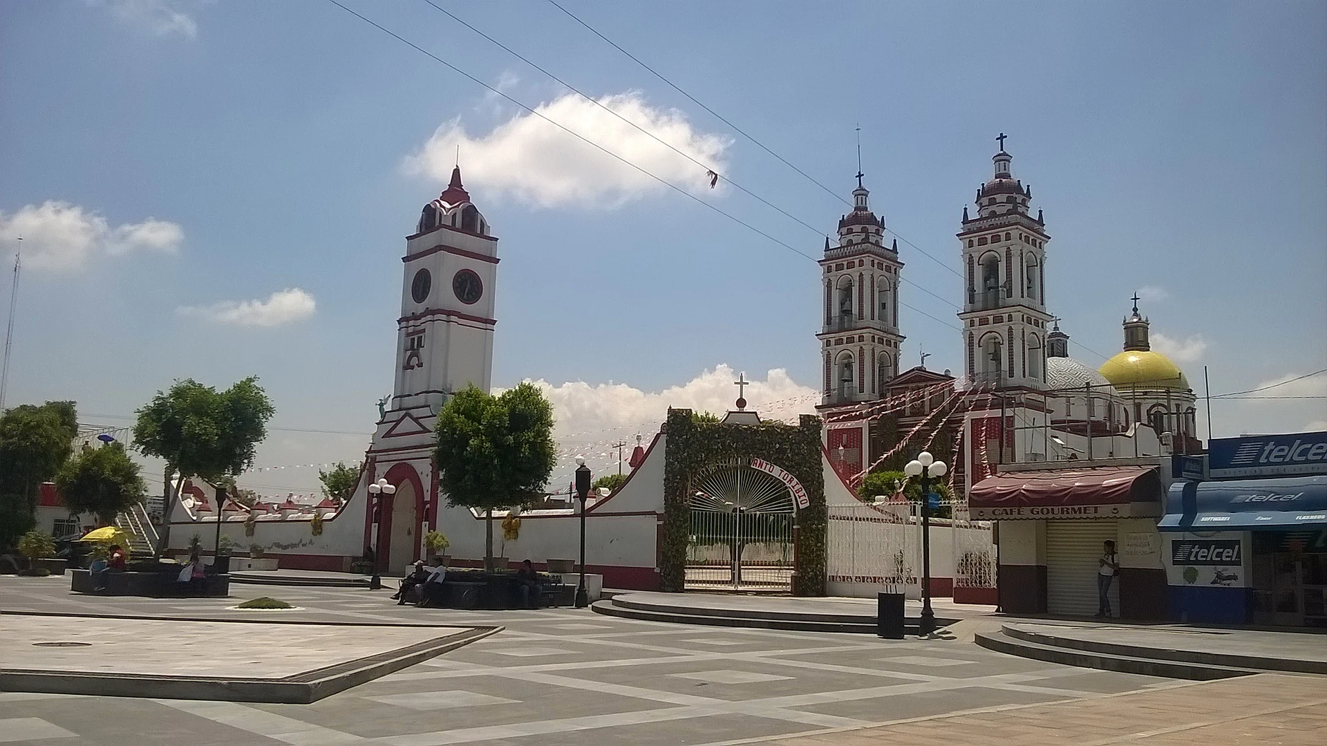
Santo Toribio Xicohtzinco, on the Puebla border: a twin-towered parish church built 1801-1803, a 16 April feast and a chivarrudos carnival.
From Puebla: 20 min by car (17 km by road) How to get there ↓
Near here


Plan your visit to Xicohtzinco
Where to stay near Xicohtzinco
Compare hotels, posadas and guest houses in Xicohtzinco.
Tours to Xicohtzinco
Day trips around Cholula sometimes stop in Xicohtzinco; a tour is the easy way to see it without a car.
 Tours from Puebla City
Africam Safari Zoo Admission with Transportation
★ 4.8 (87) · From US$35
How to get to Xicohtzinco
- From Puebla: about 20 min by road (~17 km)
- Nearest airport: Puebla (PBC), 16 min by car to Cholula
Links open a partner site. We may earn a commission if you book, at no cost to you.
Tours from Puebla City, near Xicohtzinco


Tours, prices and ratings from Viator, checked weekly. We may earn a commission if you book.
About Xicohtzinco
Xicohtzinco, in full Santo Toribio Xicohtzinco, is the seat of the municipality of the same name at the southern tip of Tlaxcala, on federal highway 119 right on the Puebla border, which here follows the Atoyac river; the Zahuapan also crosses its land. It is part of the Puebla-Tlaxcala metropolitan area, at about 2,200 m, and the 2020 census counted 14,197 people. The Nahuatl name means "behind the jicote wasp" or "behind the wasps", and the patron is Toribio of Liébana, a 5th-century bishop of Astorga. The municipality covers just 7.33 km² and is made up almost entirely of the town and its thirteen barrios, among them El Llano, Chalmita, Techaloya, Santa Filomena and El Cerrito.
The site was already a village in the Texoloc phase (800-350 BC), and stone fibre-scrapers used to pull ixtle from maguey leaves have been found here; when the Spanish arrived it belonged to the fourth tequitl of Ocotelulco, and it became a visiting church of the Franciscan friary at Tepeyanco. In 1899 its people and those of Papalotla jointly bought the Pulula hacienda to form a farming partnership. On 16 September 1910, during the Independence celebrations, a clash between Madero supporters and soldiers in the plaza left townspeople dead, one of the events leading up to the Revolution in Tlaxcala. In the 19th century the town answered to Zacatelco; it became a free municipality on 15 January 1942.
The parish church of Santo Toribio has a brick and tile façade, an atrium wall with side gateways and two three-tier towers topped by octagonal domes; an inscription dates the work from 3 January 1801 to 8 May 1803, and the second dome was built between 1897 and 1900. Inside are Neoclassical altarpieces and Baroque estípite ones. The Santa Filomena chapel was founded in 1860.
The main feast is 16 April, St Toribio's day, and on the second Friday of Lent processions arrive from neighbouring towns for the feast of the Precious Blood of Christ. At carnival, as in Zacatelco, the chivarrudos come out: a satire of 19th-century foremen and landowners in leather chaps and hats covered in coloured paper, leaping to the huehuetl drum around a cardboard bull and finishing by burning firework bulls; huehues, charros and the Casamiento Indígena (Indigenous Wedding) dance too. Local cooking includes anise tamales, pollo en xoma and green mole with beef trotters.
How to get to Xicohtzinco
Drive from Puebla: 20 min, 17 km
Xicohtzinco is on federal highway 119 between Puebla and Tlaxcala, between Papalotla and Zacatelco. From central Puebla it is about 17 km (around 19 minutes by car), and a taxi from the CAPU bus station takes about 15 minutes; from Tlaxcala city it is about 18 km (around 20 minutes) along the same 119 through Zacatelco. By bus from Mexico City, go to CAPU in Puebla (from TAPO) or to the Tlaxcala bus station and continue down the 119 by local bus or taxi. Cholula, the nearest pueblo mágico, is about 19 km away (around 20 minutes).
Directions to Xicohtzinco on Google Maps
Distances are in a straight line; the road is usually longer.
Links open a partner site. We may earn a commission if you book, at no cost to you.
From the nearest cities to Xicohtzinco
- Puebla · 17 km by road, 20 min
- Chiautempan · 21 km by road, 20 min
- San Martín Texmelucan · 32 km by road, 30 min
Drive times by road from OpenStreetMap, without traffic or stops. Times marked ~ are estimated from the straight-line distance.
What to see in Xicohtzinco 1
Sights with their own page, closest to the centre first.
-
Laguna de Acomulco · Lagoon · 3 km from the centre
A lagoon of about 20,000 m² in Zacatelco's fourth section, fed by springs and under restoration since the 2010s.
Map of Xicohtzinco
Neighbourhoods and villages of Xicohtzinco
Part of Xicohtzinco or just outside it, closest first.
-
Papalotla · Town · 3 km from the centre
Valley town between Puebla and Tlaxcala, with a charro carnival, the old Panzacola station and a fair around October. -
San Lorenzo Almecatla · Town · 3 km from the centre
Town in Cuautlancingo north of Puebla, scene of the Battle of San Lorenzo against the French army on 8 May 1863. -
San Marcos Contla · Town · 3 km from the centre
Second-largest locality of Papalotla, 3 km from the seat on federal highway 121: San Marcos church and fiesta on 25 April. -
Santa Catarina Ayometla · Town · 3 km from the centre
Municipal seat in southern Tlaxcala: 18th-century parish of Santa Catarina, tinsmithing and a patron-saint fiesta on 25 November. -
Santa Cruz Quilehtla · Town · 4 km from the centre
Seat of a young municipality in southern Tlaxcala: carnival chivarrudos, rockets and paper flowers, and the Holy Cross fiesta on 3 May. -
Tenancingo · Town · 4 km from the centre
A town in southern Tlaxcala next to Puebla, with the San Miguel parish and a carnival of toreros and charros.

Day trips and tours from Xicohtzinco
The closest Pueblos Mágicos and places to visit, with the drive from Xicohtzinco and tours that leave from it.


Times marked ~ are estimated from the distance. Links open a partner site. We may earn a commission if you book, at no cost to you.
Before you go: getting to and around Xicohtzinco
- The nearest airport is Puebla (PBC).
- The best months to go are January, February, March, and December.
- 2 of the places on this page are more than 3 km from the centre: take a taxi, a ride-hailing app or a local bus.
- For day trips a rental car gives the most freedom; the tours above leave from Xicohtzinco.
Before you go to Xicohtzinco: hours, prices and tips
- Best season
- Feast of St Toribio on 16 April; Precious Blood of Christ on the second Friday of Lent; chivarrudos carnival in the week before Ash Wednesday; Candlemas on 2 February. Wikipedia (es) · checked Oct 2026
Hours and prices change, especially around holidays. Each fact links to where we checked it.
Visiting Xicohtzinco: what to see and do
The 1801-1803 parish church of Santo Toribio, with its two towers and Neoclassical and estípite altarpieces.
The Santa Filomena chapel, founded in 1860.
The chapels of the thirteen barrios, each with its own feast.
The chivarrudos carnival, ending with burning firework bulls.
The feast of the Precious Blood of Christ on the second Friday of Lent.
Plan your trip
Places to stay in Xicohtzinco
Compare hotels, posadas, and rentals in and around Xicohtzinco.
Tours & activities
Day trips around Cholula sometimes stop in Xicohtzinco; a tour is the easy way to see it without a car.
Rental cars
Pick up a car at PBC (Puebla): about 16 min by road to Cholula, then 15 km more to Xicohtzinco, on your own schedule.
Flights
The nearest airport with scheduled flights is Puebla (PBC), about 16 min by road from Cholula, the base for Xicohtzinco.
Mobile data
Signal can drop away from Cholula: download a map of the way to Xicohtzinco before you set out, or carry an eSIM with data.
Links open a partner site. We may earn a commission if you book, at no cost to you.
When to go to Xicohtzinco mild
Xicohtzinco shares the climate of Cholula, 15 km away. The best months to visit are January, February, March, and December.
See the month-by-month climate of Cholula
Weather in Xicohtzinco now and the next 7 days
Live forecast from Open-Meteo. Chance of rain is the day's highest.
The closest Pueblo Mágico: Cholula

Cholula is the Pueblo Mágico closest to Xicohtzinco, with places to stay, food, and more to see.
Also close to
- Huejotzingo · Puebla · 18 km away
- Ixtenco · Tlaxcala · 33 km away
- Atlixco · Puebla · 36 km away
- Huamantla · Tlaxcala · 36 km away
- Tlaxco · Tlaxcala · 50 km away
Near Xicohtzinco




Drive times by road from OpenStreetMap, without traffic. Times marked ~ are estimated from the straight-line distance.
Location from OpenStreetMap. Written by Puebloteca.