
Village Nealtican, Puebla Volcano Route Monasteries on the slopes of Popocatépetl Puebla Valley
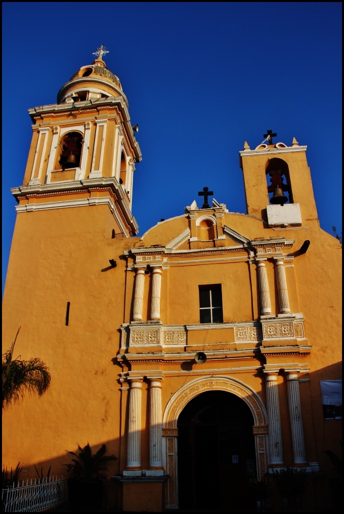
Seat of Nealtican, "place where I bathe", below Popocatépetl, beside a lava field with quarries and a parish church finished in 1739.
From Atlixco: 25 min by car (20 km by road) How to get there ↓
Near here
See everything nearby ↓


Plan your visit to San Buenaventura Nealtican
Where to stay near San Buenaventura Nealtican
Compare hotels, posadas and guest houses in San Buenaventura Nealtican.
Tours to San Buenaventura Nealtican
Day trips and guided outings from Cholula often include San Buenaventura Nealtican; with a local guide you can get there without a car.
How to get to San Buenaventura Nealtican
- From Atlixco: about 25 min by road (~20 km)
- Nearest airport: Puebla (PBC), 16 min by car to Cholula
Links open a partner site. We may earn a commission if you book, at no cost to you.
About San Buenaventura Nealtican
Some 2,100 years ago an eruption of Popocatépetl left a sheet of volcanic rock at this town's doorstep: the Nealtican malpaís, which runs along the whole southern edge of the municipality even though most of it now lies in Tianguismanalco. That stone shaped local life early on. From the 5th century there was an Olmeca-Xicalanca presence here, and the Nealtican, San Nicolás de los Ranchos and Xalitzintla area traded rock from the lava field to make tools such as molcajetes. Stone is still quarried along the edges of the flow today. San Buenaventura Nealtican, the municipal seat, had 13,243 inhabitants in 2020 and sits at 2,231 metres on the western side of the Puebla-Tlaxcala valley.
The name comes from Nahuatl and translates as "place where I bathe", from neh (I), altia (to bathe) and -can (place). Repeated eruptions pushed the first settlers toward safer ground such as Cholula; later Nahua groups resettled the area and the town ended up paying tribute to Mexico-Tenochtitlan. After the Conquest the Franciscan Bonaventure (Buenaventura de Fidanza) was named its patron, and his parish church was completed in 1739. After Independence it belonged to the district of Atlixco; it became a municipality on 8 April 1920 and a free municipality in 1930. The territory covers 62.5 km² and borders Calpan, San Jerónimo Tecuanipan, Tianguismanalco and San Nicolás de los Ranchos.
The land slopes gently down to the east, toward Cholula and Puebla, and climbs to the west, toward the Paso de Cortés and the two volcanoes. Its only notable hills are Xaltepec (2,320 m) and Teotón (2,590 m), and together with the edges of the lava field along the Xalapexco river they hold the only woodland. Two year-round rivers, the Atlanepantla and the Ajalanti, flow through it as part of the Atoyac basin. Two thirds of the land is farmed, mostly in small rain-fed plots; irrigated fields grow flowers and vegetables. Besides quarrying, people make concrete blocks and ceiling blocks, and in recent decades many music groups have sprung up here, mariachi bands above all.
How to get to San Buenaventura Nealtican
Drive from Atlixco: 25 min, 20 km
Nealtican lies about 24 km in a straight line west of Puebla city and 12 km from Huejotzingo. The most direct way is to head to Cholula first and then keep going west toward the volcanoes, between the neighbouring municipalities of Calpan and San Jerónimo Tecuanipan; Atlixco, seat of its old district, lies to the south. It is the natural gateway to San Nicolás de los Ranchos and the Paso de Cortés.
Directions to San Buenaventura Nealtican on Google Maps
Distances are in a straight line; the road is usually longer.
Links open a partner site. We may earn a commission if you book, at no cost to you.
From the nearest cities to San Buenaventura Nealtican
- Atlixco · 20 km by road, 25 min
- San Martín Texmelucan · 28 km by road, 30 min
- Puebla · 28 km by road, 35 min
Drive times by road from OpenStreetMap, without traffic or stops. Times marked ~ are estimated from the straight-line distance.
Visiting San Buenaventura Nealtican: what to see and do
The parish church of San Buenaventura has a plain front with a bell tower, pilasters and scrollwork; inside are gilded Solomonic and Churrigueresque altarpieces, a neoclassical baldachin for the saint and an old bellows organ in the choir, and a stone cross stands in the centre. You can hike the lava field and climb Teotón hill. The patron feast falls on the Sunday after 14 July, and every May the Feria del Mole draws thousands of diners over one weekend.
Plan your trip
Places to stay in San Buenaventura Nealtican
Compare hotels, posadas, and rentals in and around San Buenaventura Nealtican.
Tours & activities
Day trips and guided outings from Cholula often include San Buenaventura Nealtican; with a local guide you can get there without a car.
Rental cars
Pick up a car at PBC (Puebla): about 16 min by road to Cholula, then 12 km more to San Buenaventura Nealtican, on your own schedule.
Flights
The nearest airport with scheduled flights is Puebla (PBC), about 16 min by road from Cholula, the base for San Buenaventura Nealtican.
Mobile data
Signal can drop away from Cholula: download a map of the way to San Buenaventura Nealtican before you set out, or carry an eSIM with data.
Links open a partner site. We may earn a commission if you book, at no cost to you.
When to go to San Buenaventura Nealtican mild
San Buenaventura Nealtican shares the climate of Cholula, 12 km away. The best months to visit are January, February, March, and December.
See the month-by-month climate of Cholula
Weather in San Buenaventura Nealtican now and the next 7 days
Live forecast from Open-Meteo. Chance of rain is the day's highest.
The closest Pueblo Mágico: Cholula

Cholula is the Pueblo Mágico closest to San Buenaventura Nealtican, with places to stay, food, and more to see.
Also close to
- Huejotzingo · Puebla · 12 km away
- Atlixco · Puebla · 15 km away
- Ixtenco · Tlaxcala · 56 km away
- Tlayacapan · Morelos · 59 km away
- Huamantla · Tlaxcala · 61 km away
Closest to San Buenaventura Nealtican
-
San Miguel Papaxtla · Village · 4 km away
-
Tecajete · Mountain · 4 km away
-
San Jerónimo Tecuanipan · Village · 5 km away
-
Santa María Acuexcomac · Village · 5 km away
-
Cháhuac · Village · 7 km away
-
San Andrés Calpan · Landmark · 7 km away
-
San Francisco Cuapan · Village · 7 km away
-
San Nicolás de los Ranchos · Town · 7 km away


Near San Buenaventura Nealtican




Drive times by road from OpenStreetMap, without traffic. Times marked ~ are estimated from the straight-line distance.
Location from OpenStreetMap. Written by Puebloteca.