Waterfall San Nicolás de los Ranchos, Puebla Municipality of San Nicolás de los Ranchos Volcano Route
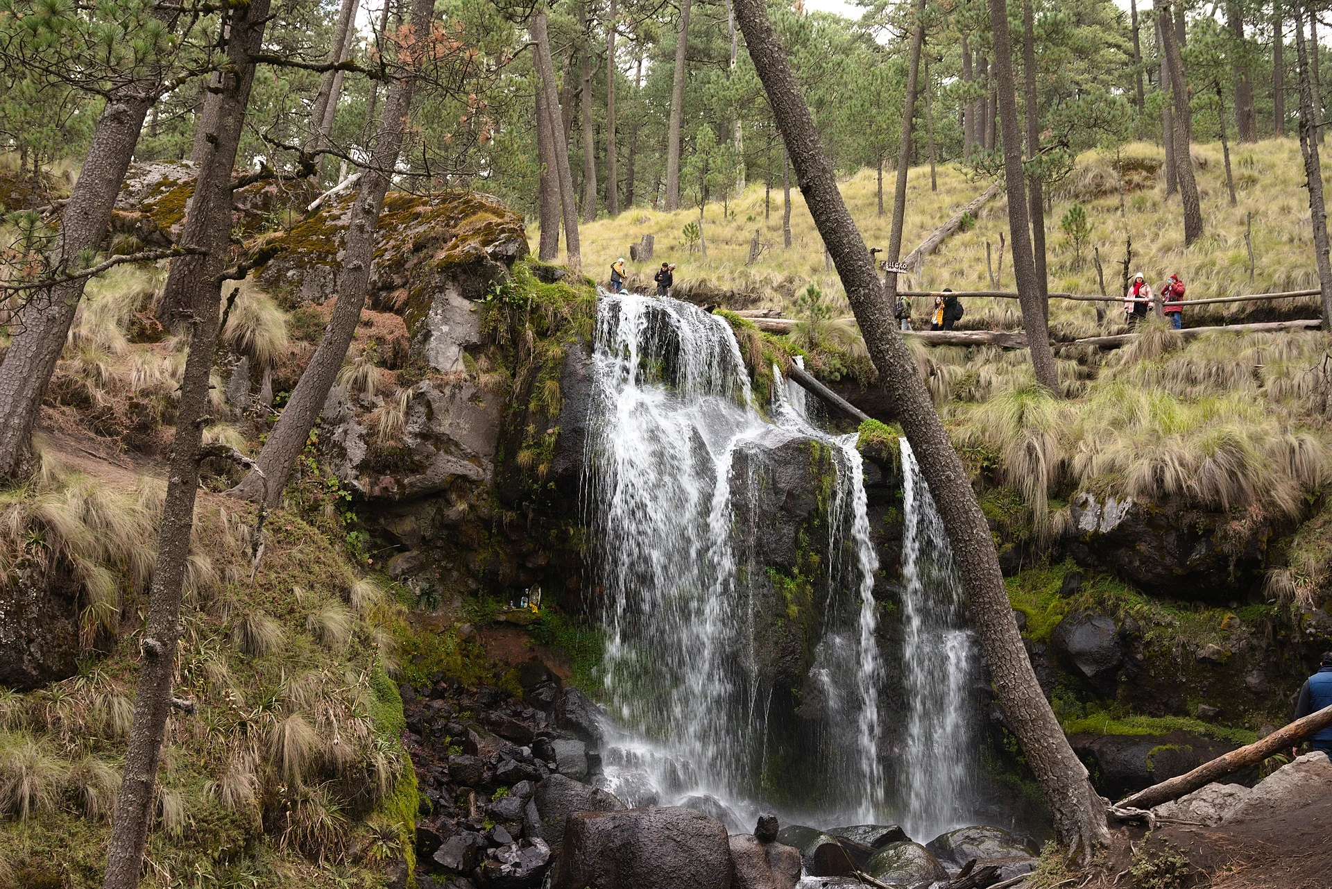
A roughly 50 m waterfall fed by Iztaccíhuatl's meltwater, in Apatlaco Eco Park, with cabins and camping on the road up to Paso de Cortés.
From Atlixco: 1 h 5 min by car (48 km by road) How to get there ↓
Near here
See everything nearby ↓



Plan your visit to Cascada de Apatlaco
Where to stay near Cascada de Apatlaco
Compare hotels, posadas and guest houses in Cascada de Apatlaco.
Tours to Cascada de Apatlaco
Day trips and guided outings from Huejotzingo often include Cascada de Apatlaco; with a local guide you can get there without a car.
 Tours from Atlixco
Atlixco Volcano Views Popocatépetl Tour Forest Route
From US$108
How to get to Cascada de Apatlaco
- From Atlixco: about 1 h 5 min by road (~48 km)
- Nearest airport: Puebla (PBC), 7 min by car to Huejotzingo
Links open a partner site. We may earn a commission if you book, at no cost to you.
Tours from Atlixco, near Cascada de Apatlaco
Tours, prices and ratings from Viator, checked weekly. We may earn a commission if you book.
About Cascada de Apatlaco
The Apatlaco waterfall lies in Apatlaco Eco Park, within Iztaccíhuatl-Popocatépetl National Park, in the municipality of San Nicolás de los Ranchos in western Puebla. It sits at about 3,550 m on the slopes of Iztaccíhuatl and is fed by the volcano's meltwater. It is said to drop about 50 m.
A wooden boardwalk of about a kilometre leads from the base of the park to the main fall, through forest and streams. The park also has cabins, about 1,500 pesos a night for a two-bedroom one and 2,000 for the larger ones, a camping area for your own tent, horse rides, pedal boats on a small lake, a zip line and evening campfires. Popocatépetl is visible from the park.
The municipality of San Nicolás de los Ranchos climbs from the Puebla valley to the summit of Popocatépetl at about 5,400 m, and also takes in part of the Iztaccíhuatl massif, including 3,780 m Cerro Gordo. At this height it is cold, especially at night, and the rainy season, in summer and early autumn, is when the fall carries the most water. Food and drink vendors work on site, though they usually start selling around 11 am.
How to get to Cascada de Apatlaco
Drive from Atlixco: 1 h 5 min, 48 km
From Puebla, take the Paso de Cortés road from central Cholula, through San Gregorio Zacapechpan, Santa María Acuexcomac, San Buenaventura Nealtican and San Nicolás de los Ranchos; around km 50 you reach the stone arches at the entrance, then 1 km north to the restaurant and cabins. From Mexico City, take federal highway 115 to Amecameca, then the turn-off to San Pedro Nexapa and about 20 km on the Paso de Cortés road to the arches. It is about two hours from Puebla or Mexico City.
Directions to Cascada de Apatlaco on Google Maps
Distances are in a straight line; the road is usually longer.
Links open a partner site. We may earn a commission if you book, at no cost to you.
From the nearest cities to Cascada de Apatlaco
- Atlixco · 48 km by road, 1 h 5 min
- San Martín Texmelucan · 53 km by road, 1 h 10 min
- Cuautla · 68 km by road, 1 h 10 min
Drive times by road from OpenStreetMap, without traffic or stops. Times marked ~ are estimated from the straight-line distance.
Before you go to Cascada de Apatlaco: hours, prices and tips
- Entry
- Entry about 30 pesos per person (another source says 40); cabins, horses and boats cost extra. México Desconocido · checked Oct 2026
- Best time of day
- Food stalls start selling around 11 am. Trendencias · checked Oct 2026
- Best season
- Rains come in summer and early autumn, when the fall carries the most water. México Desconocido · checked Oct 2026
- What to bring
- Sportswear, comfortable shoes, warm layers for the night, a cap, sunglasses and sunscreen. México Desconocido · checked Oct 2026
Hours and prices change, especially around holidays. Each fact links to where we checked it.
Visiting Cascada de Apatlaco: what to see and do
The main fall, about 50 m high, a kilometre along a wooden boardwalk.
Views of Popocatépetl from the park.
The cabins and camping area.
Horse rides, the zip line and boats on the lake.
Plan your trip
Places to stay in Cascada de Apatlaco
Compare hotels, posadas, and rentals in and around Cascada de Apatlaco.
Tours & activities
Day trips and guided outings from Huejotzingo often include Cascada de Apatlaco; with a local guide you can get there without a car.
Rental cars
Pick up a car at PBC (Puebla): about 7 min by road to Huejotzingo, then 24 km more to Cascada de Apatlaco, on your own schedule.
Flights
The nearest airport with scheduled flights is Puebla (PBC), about 7 min by road from Huejotzingo, the base for Cascada de Apatlaco.
Travel insurance
If you plan on swimming and hiking at Cascada de Apatlaco, check that your policy covers it: some plans leave adventure activities out.
Mobile data
Signal can drop away from Huejotzingo: download a map of the way to Cascada de Apatlaco before you set out, or carry an eSIM with data.
Links open a partner site. We may earn a commission if you book, at no cost to you.
When to go to Cascada de Apatlaco mild
Cascada de Apatlaco shares the climate of Huejotzingo, 24 km away. The best months to visit are January, February, March, and November.
Waterfalls like Cascada de Apatlaco run fullest in the rainiest months here (July, August, and September) and can thin out at the end of the dry season (February, March, and November).
See the month-by-month climate of Huejotzingo
Weather in Cascada de Apatlaco now and the next 7 days
Live forecast from Open-Meteo. Chance of rain is the day's highest.
The closest Pueblo Mágico: Huejotzingo

Huejotzingo is the Pueblo Mágico closest to Cascada de Apatlaco, with places to stay, food, and more to see.
Also close to
- Atlixco · Puebla · 30 km away
- Cholula · Puebla · 34 km away
- Tlayacapan · Morelos · 41 km away
- Tepoztlán · Morelos · 52 km away
- Otumba · Estado de México · 67 km away
Closest to Cascada de Apatlaco
-
Paso de Cortés · Mountain · 3 km away
-
Pico Teyotl · Mountain · 9 km away
-
San Mateo Ozolco · Village · 12 km away
-
Santiago Xalitzintla · Village · 12 km away
-
Santa María Atexcac · Village · 14 km away
-
Amecameca de Juárez · Town · 15 km away
-
San Diego Huehuecalco · Village · 15 km away
-
San Nicolás de los Ranchos · Town · 15 km away


Near Cascada de Apatlaco




Drive times by road from OpenStreetMap, without traffic. Times marked ~ are estimated from the straight-line distance.
Lists with Cascada de Apatlaco
Waterfalls in Puebla · 13 Waterfalls near Puebla · 3 Waterfalls near Cuautla · 4Location from OpenStreetMap. Written by Puebloteca.