
Landmark Cuauhtémoc, Ciudad de México Municipality of Cuauhtémoc Valley of Mexico
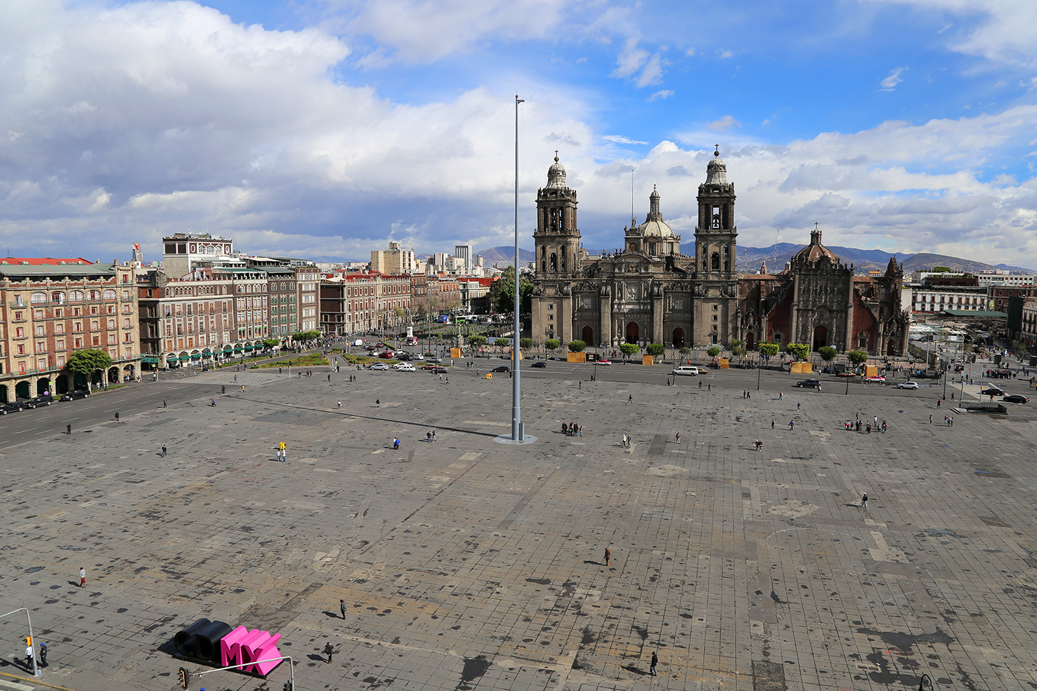
Mexico's main square, about 240 m a side and pedestrian since 2024: the giant flag, the Grito on 15 September and record-breaking free concerts.
From Toluca: 1 h 5 min by car (66 km by road) How to get there ↓
Near here
See everything nearby ↓


Plan your visit to Zócalo
Where to stay near Zócalo
Compare hotels, posadas and guest houses in Zócalo.
Tours to Zócalo
Look for tours of the area around Tepotzotlán that stop at Zócalo.
 Bike Tour through Chapultepec, Reforma and the Zócalo / Mexico
★ 5.0 (18) · From US$72
How to get to Zócalo
- From Toluca: about 1 h 5 min by road (~66 km)
- Nearest airport: Mexico City (Felipe Ángeles) (NLU), 48 min by car to Tepotzotlán
Links open a partner site. We may earn a commission if you book, at no cost to you.
Popular tours to Zócalo


Tours, prices and ratings from Viator, checked weekly. We may earn a commission if you book.
About Zócalo
The Zócalo, officially the Plaza de la Constitución, is Mexico's main square and one of the largest city squares in the world, an open paved space of roughly 240 metres a side. The cathedral closes its north side, the long façade of the Palacio Nacional fills the east, the old city hall and its twin government building line the south, and the arcades of the Portal de Mercaderes, with shops and hotels, run along the west. In the middle there is nothing but a single flagpole carrying a huge Mexican flag.
Before the conquest this was open ground at the centre of Tenochtitlan, beside the walled sacred precinct of the Templo Mayor. The Spanish kept it as their main plaza, and over the centuries it held a market, the Parián (a block of shops from 1703 until Santa Anna had it torn down in 1843), and later gardens and a bandstand. It took its formal name in 1813, when the Cádiz Constitution was sworn there. The nickname has a story of its own: in 1843 Santa Anna commissioned an independence monument for the middle of the square, but only the plinth (zócalo) was ever built, and the word stuck to the plaza and later to main squares all over Mexico. Its bare, open look dates from 1958.
This is where the country gathers. Just before 11 pm every 15 September the president rings the bell and gives the Grito de Dolores from the palace balcony to a packed square; it is the stage for the Day of the Dead parade, for national protests and for huge free concerts, the largest of them Shakira's on 1 March 2026, with more than 400,000 people. In winter it has hosted an ice rink. On ordinary days you will find Aztec-style dancers (concheros) drumming near the cathedral, and at about 6 pm soldiers lower the giant flag and carry it into the Palacio Nacional.
In 2024 the city closed the streets along three sides of the square to cars, and the plaza was reopened as the pedestrian Zócalo in May that year. Large events and protests can close parts of it at short notice.
How to get to Zócalo
Drive from Toluca: 1 h 5 min, 66 km
Metro Line 2 stops right under the square at Zócalo/Tenochtitlan (between Allende and Pino Suárez), with exits beside the cathedral, beside the Palacio Nacional and on the south side along Pino Suárez; there is no sign above ground, and the station is often closed during big events and protests. On Metrobús Line 4, the 20 de Noviembre stop (southbound route) is one block south. From Madero street the square is a short walk east.
Directions to Zócalo on Google Maps
Distances are in a straight line; the road is usually longer.
Links open a partner site. We may earn a commission if you book, at no cost to you.
From the nearest cities to Zócalo
- Toluca · 66 km by road, 1 h 5 min
- Cuernavaca · 74 km by road, 1 h 15 min
- San Martín Texmelucan · 94 km by road, 1 h 15 min
Drive times by road from OpenStreetMap, without traffic or stops. Times marked ~ are estimated from the straight-line distance.
Before you go to Zócalo: hours, prices and tips
- Best time of day
- Come at about 6 pm, when soldiers lower the giant flag and carry it into the Palacio Nacional. Wikivoyage · checked Oct 2026
- Best season
- The square is busiest on the night of 15 September for the Grito and on 16 September for Independence Day; in December it has had an ice rink. Wikivoyage · checked Oct 2026
Hours and prices change, especially around holidays. Each fact links to where we checked it.
Visiting Zócalo: what to see and do
Stand in the middle of the square for the view of the cathedral, the Palacio Nacional and the old city hall around you.
Watch the giant flag being lowered by soldiers at about 6 pm.
See the concheros dance to drums near the cathedral.
Come on the night of 15 September for the Grito, or in late October and early November for the Day of the Dead events.
Walk the arcades of the Portal de Mercaderes on the west side.
Look into the ruins of the Templo Mayor, just off the square's northeast corner.
Plan your trip
Places to stay in Zócalo
Compare hotels, posadas, and rentals in and around Zócalo.
Tours & activities
Look for tours of the area around Tepotzotlán that stop at Zócalo.
Rental cars
Pick up a car at NLU (Mexico City (Felipe Ángeles)): about 48 min by road to Tepotzotlán, then 33 km more to Zócalo, on your own schedule.
Flights
The nearest airport with scheduled flights is Mexico City (Felipe Ángeles) (NLU), about 48 min by road from Tepotzotlán, the base for Zócalo.
Mobile data
Signal can drop away from Tepotzotlán: download a map of the way to Zócalo before you set out, or carry an eSIM with data.
Links open a partner site. We may earn a commission if you book, at no cost to you.
When to go to Zócalo cool
Zócalo shares the climate of Tepotzotlán, 33 km away. The best months to visit are January, February, March, and December.
See the month-by-month climate of Tepotzotlán
Weather in Zócalo now and the next 7 days
Live forecast from Open-Meteo. Chance of rain is the day's highest.
The closest Pueblo Mágico: Tepotzotlán

Tepotzotlán is the Pueblo Mágico closest to Zócalo, with places to stay, food, and more to see.
Also close to
- Teotihuacán · Estado de México · 42 km away
- Villa del Carbón · Estado de México · 48 km away
- Otumba · Estado de México · 49 km away
- Tepoztlán · Morelos · 50 km away
- Metepec · Estado de México · 53 km away
Closest to Zócalo
-
Antiguo Colegio de San Ildefonso · Landmark · 0 km away
-
Catedral Metropolitana · Landmark · 0 km away
-
Centro Histórico · Landmark · 0 km away
-
Ciudad de México · City · 0 km away
-
Palacio Nacional · Landmark · 0 km away
-
Templo Mayor · Archaeological site · 0 km away
-
Alameda Central · Landmark · 1 km away
-
Casa de los Azulejos · Landmark · 1 km away


Near Zócalo


Drive times by road from OpenStreetMap, without traffic. Times marked ~ are estimated from the straight-line distance.
Location from OpenStreetMap. Written by Puebloteca.