
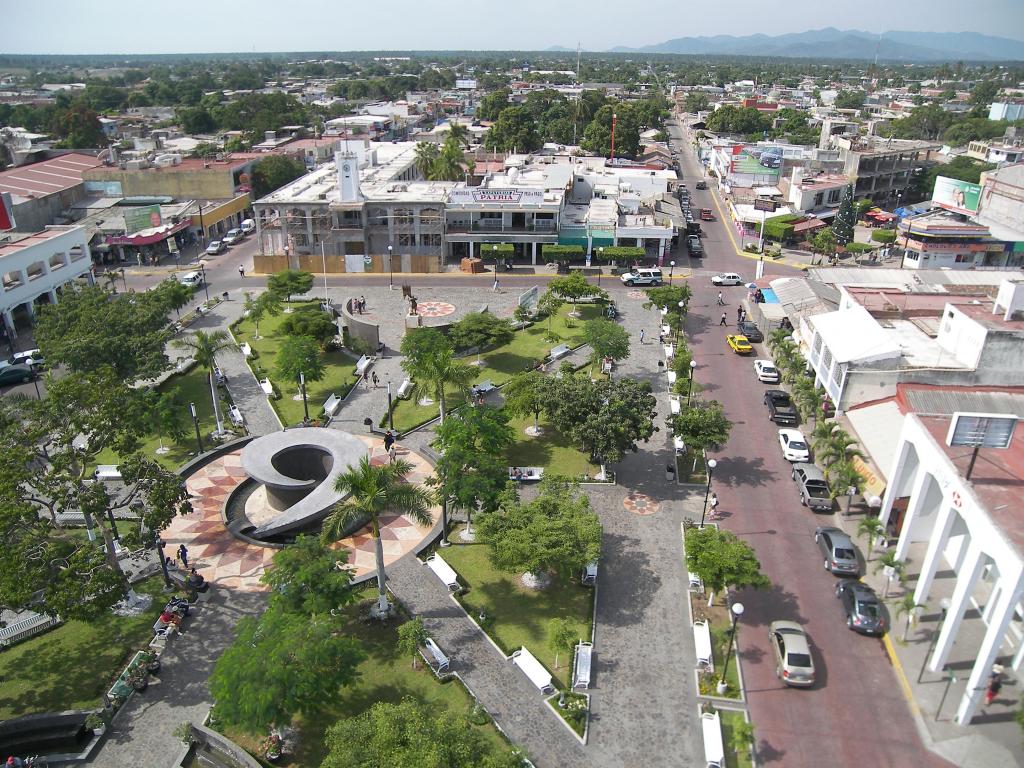
City Tecomán, Colima Colima coast
The farm city of Colima's coastal plain, self-styled lime capital of the world, near the surf beaches of Boca de Pascuales and El Real.
From Colima: 45 min by car (48 km by road) How to get there ↓
Near here
See everything nearby ↓



Plan your visit to Tecomán
Where to stay near Tecomán
Compare hotels, posadas and guest houses in Tecomán.
Tours to Tecomán
Day trips and guided outings from Comala often include Tecomán; with a local guide you can get there without a car.
How to get to Tecomán
- From Colima: about 45 min by road (~48 km)
- Nearest airport: Colima (CLQ), 32 min by car to Comala
Links open a partner site. We may earn a commission if you book, at no cost to you.
About Tecomán
Tecomán is a city on the hot coastal plain of southern Colima, about 47 km south of the state capital and a little over 10 km inland from the Pacific. It had 88,337 people at the 2020 census (116,305 in the municipality), and with neighbouring Armería it forms a metropolitan area of about 144,000. The valley around it is one of the richest farming areas of western Mexico, planted with limes, coconut palms, tamarind, mango and bananas, and Tecomán calls itself the lime capital of the world; local packers and processors use almost the whole fruit, pressing oil from the peel and leaves and extracting pectin. The name is usually translated from Nahuatl as place of our grandfathers.
When the Spanish arrived, the valley was home to the Tecos, whose town of Caxitlán was the strongest in the kingdom of Colima. In July 1523 Gonzalo de Sandoval founded the first Spanish Villa de Colima at Caxitlán, and that same year an Indigenous town, Santiago de Tecomán, was laid out two leagues away. The Spanish town soon moved to the present site of Colima, and Caxitlán declined, especially after a fire destroyed its church around 1800; the bare walls of its old inn still stand about 5 km north of Tecomán's railway station. In 2017 the state congress gave Tecomán the title of Heroica Ciudad for its people's resistance during the conquest.
The symbol of the modern city is El Limonero, also called the Tree of Life, a 33-metre sculpture by Sebastián weighing 110 tonnes and decorated with ten limes, one for each of the state's municipalities; another roundabout has giant figures of tlalchichis, the ancient Colima dogs. The Casa de la Cultura has a small museum of pre-Columbian pottery. The big dates are the Feria Nacional del Limón in January and early February, and the feast of the Virgen de la Candelaria on 2 February, with a procession held since 1876 and, the following Saturday, a 13 km pilgrimage carrying the image to the beach at Boca de Pascuales. Pascuales, about 12 km away, is known for powerful surf and seafood enramadas; El Real, 10 km south, also draws surfers, and the Laguna de Alcuzahue, 8 km away, has a crocodile reserve.
How to get to Tecomán
Drive from Colima: 45 min, 48 km
Tecomán is about 47 km south of Colima by highway, roughly 45 minutes by car; buses leave from both of Colima's main terminals throughout the day and take about one to two hours depending on stops. Buses from Manzanillo also run here, usually stopping in Armería on the way. The nearest airports are Colima's (CLQ), about 70 km away, and Manzanillo's Playa de Oro (ZLO), about 86 km away.
Directions to Tecomán on Google Maps
Distances are in a straight line; the road is usually longer.
Links open a partner site. We may earn a commission if you book, at no cost to you.
From the nearest cities to Tecomán
- Colima · 48 km by road, 45 min
- Manzanillo · 58 km by road, 45 min
- Ciudad Guzmán · 120 km by road, 1 h 35 min
Drive times by road from OpenStreetMap, without traffic or stops. Times marked ~ are estimated from the straight-line distance.
Before you go to Tecomán: hours, prices and tips
- Best season
- Feria Nacional del Limón in January and the first days of February; Virgen de la Candelaria procession on 2 February and pilgrimage to Boca de Pascuales on the following Saturday. Wikipedia (es) · checked Oct 2026
Hours and prices change, especially around holidays. Each fact links to where we checked it.
Visiting Tecomán: what to see and do
See El Limonero, Sebastián's 33-metre lime-tree sculpture, on its roundabout beside the Casa de la Cultura.
Visit the small pre-Columbian pottery museum at the Casa de la Cultura.
Watch the surf and eat seafood in the enramadas at Boca de Pascuales, about 12 km away.
See the crocodiles at the Laguna de Alcuzahue, 8 km from the city.
Come for the Feria Nacional del Limón and the Candelaria procession and pilgrimage to the sea in early February.
Plan your trip
Places to stay in Tecomán
Compare hotels, posadas, and rentals in and around Tecomán.
Tours & activities
Day trips and guided outings from Comala often include Tecomán; with a local guide you can get there without a car.
Rental cars
Pick up a car at CLQ (Colima): about 32 min by road to Comala, then 47 km more to Tecomán, on your own schedule.
Flights
The nearest airport with scheduled flights is Colima (CLQ), about 32 min by road from Comala, the base for Tecomán.
Mobile data
Signal can drop away from Comala: download a map of the way to Tecomán before you set out, or carry an eSIM with data.
Links open a partner site. We may earn a commission if you book, at no cost to you.
When to go to Tecomán warm
Tecomán shares the climate of Comala, 47 km away. The best months to visit are January, February, November, and December.
See the month-by-month climate of Comala
Weather in Tecomán now and the next 7 days
Live forecast from Open-Meteo. Chance of rain is the day's highest.
The closest Pueblo Mágico: Comala

Comala is the Pueblo Mágico closest to Tecomán, with places to stay, food, and more to see.
Closest to Tecomán
-
Armería · Town · 10 km away
-
Boca de Pascuales · Beach · 11 km away
-
El Paraíso · Village · 13 km away
-
Cuyutlán · Village · 21 km away
-
Centro Histórico de Colima · Landmark · 40 km away
-
Colima · City · 40 km away
-
San Juan de Alima · Village · 42 km away
-
Villa de Álvarez · City · 42 km away


Near Tecomán


Drive times by road from OpenStreetMap, without traffic. Times marked ~ are estimated from the straight-line distance.
Location from OpenStreetMap. Written by Puebloteca.