
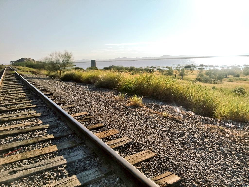
Lake Hermosillo, Sonora Municipality of Hermosillo
Hermosillo's 1948 dam on its eastern edge, where the Sonora and San Miguel rivers meet; usually dry, but it fills after exceptional rains.
From Hermosillo: 20 min by car (12 km by road) How to get there ↓
Near here
See everything nearby ↓

Plan your visit to Presa Abelardo L. Rodríguez
Where to stay near Presa Abelardo L. Rodríguez
Compare hotels, posadas and guest houses in Presa Abelardo L. Rodríguez.
Tours to Presa Abelardo L. Rodríguez
Day trips and guided outings from Ures often include Presa Abelardo L. Rodríguez; with a local guide you can get there without a car.
How to get to Presa Abelardo L. Rodríguez
- From Hermosillo: about 20 min by road (~12 km)
- Nearest airport: Hermosillo (HMO), 1 h 28 min by car to Ures
Links open a partner site. We may earn a commission if you book, at no cost to you.
About Presa Abelardo L. Rodríguez
The Abelardo L. Rodríguez dam closes off the valley on the eastern edge of Hermosillo, at the point where the Sonora and San Miguel rivers join. Governor Abelardo L. Rodríguez proposed it in 1944 to deal with the capital's chronic water shortage, and he opened it on April 5, 1948, with President Miguel Alemán at his side. Engineers first planned it upstream at El Molinito but moved it to the confluence to catch the San Miguel's flow as well. The wall stands 36 m high, and the reservoir was built for about 254 million cubic meters; silt has since cut that to around 230 million.
Its job was to irrigate ejido farmland south of the Vado del Río. The plan was 15,000 hectares, but in the first year only some 8,000 were watered, because the reservoir only filled halfway. Big-water years have been rare and are still talked about. In 1983 the dam spilled for the first time, releasing around 2 million cubic meters a day, and Hurricane Octavio pushed it over the spillway again that October; it kept spilling in December 1984, and the last overflow came in 1994. The 1983 flood cut traffic across the city and isolated Highway 15, which is why the Vado del Río was later paved as a channel for floodwater.
Drought is the other half of the story. From 1995 inflows kept shrinking, and by 2010 the dam was practically dry, which pushed the state to build the Acueducto Independencia: since 2013 it has piped water to Hermosillo from El Novillo dam, 135 km away. Storage hit zero in 2021, then in 2022 the reservoir came close to full again. Depending on the year, you may find a sheet of water backed by low hills or a vast flat of dry earth and scrub.
Locals walk out along the dam and spillway, which a railway line also crosses. Take care there: in July 2025 a teenager fell about 30 m from the spillway bridge while getting out of the way of a train.
How to get to Presa Abelardo L. Rodríguez
Drive from Hermosillo: 20 min, 12 km
The dam sits on the eastern edge of Hermosillo, about 8 km from the city center, roughly 15 minutes by car. A railway line crosses at the spillway; don't walk on the tracks. To continue to Ures, the nearest Pueblo Mágico, take the Hermosillo–Ures highway east toward the Sonora River valley: about 80 km and a little over an hour.
Directions to Presa Abelardo L. Rodríguez on Google Maps
Distances are in a straight line; the road is usually longer.
Links open a partner site. We may earn a commission if you book, at no cost to you.
From the nearest cities to Presa Abelardo L. Rodríguez
- Hermosillo · 12 km by road, 20 min
- Guaymas · 140 km by road, 1 h 45 min
- Ciudad Obregón · 257 km by road, 3 h 15 min
Drive times by road from OpenStreetMap, without traffic or stops. Times marked ~ are estimated from the straight-line distance.
Visiting Presa Abelardo L. Rodríguez: what to see and do
The 36 m high 1948 dam wall across the meeting of the Sonora and San Miguel rivers.
The reservoir, full after a good monsoon or a dry scrubby flat in drought years.
The spillway that overflowed in 1983, 1984 and 1994.
The desert hills and ranges behind the water, best in late-afternoon light.
Plan your trip
Places to stay in Presa Abelardo L. Rodríguez
Compare hotels, posadas, and rentals in and around Presa Abelardo L. Rodríguez.
Tours & activities
Day trips and guided outings from Ures often include Presa Abelardo L. Rodríguez; with a local guide you can get there without a car.
Rental cars
Pick up a car at HMO (Hermosillo): about 1 h 28 min by road to Ures, then 63 km more to Presa Abelardo L. Rodríguez, on your own schedule.
Flights
The nearest airport with scheduled flights is Hermosillo (HMO), about 1 h 28 min by road from Ures, the base for Presa Abelardo L. Rodríguez.
Travel insurance
If you plan on swimming or kayaking at Presa Abelardo L. Rodríguez, check that your policy covers it: some plans leave adventure activities out.
Mobile data
Signal can drop away from Ures: download a map of the way to Presa Abelardo L. Rodríguez before you set out, or carry an eSIM with data.
Links open a partner site. We may earn a commission if you book, at no cost to you.
When to go to Presa Abelardo L. Rodríguez warm
Presa Abelardo L. Rodríguez shares the climate of Ures, 63 km away. The best months to visit are January, February, November, and December.
Presa Abelardo L. Rodríguez is best for swimming and time on the water in the warmest months (June, July, and September); in the rainiest ones (March, July, and August) expect storms in the afternoon.
See the month-by-month climate of Ures
Weather in Presa Abelardo L. Rodríguez now and the next 7 days
Live forecast from Open-Meteo. Chance of rain is the day's highest.
The closest Pueblo Mágico: Ures

Ures is the Pueblo Mágico closest to Presa Abelardo L. Rodríguez, with places to stay, food, and more to see.
Closest to Presa Abelardo L. Rodríguez
-
Villa de Seris · Landmark · 6 km away
-
Hermosillo · City · 7 km away
-
Pesqueira · Town · 35 km away
Near Presa Abelardo L. Rodríguez

Drive times by road from OpenStreetMap, without traffic. Times marked ~ are estimated from the straight-line distance.
Location from OpenStreetMap. Written by Puebloteca.