

Beach La Paz, Baja California Sur Municipality of La Paz La Paz Bay
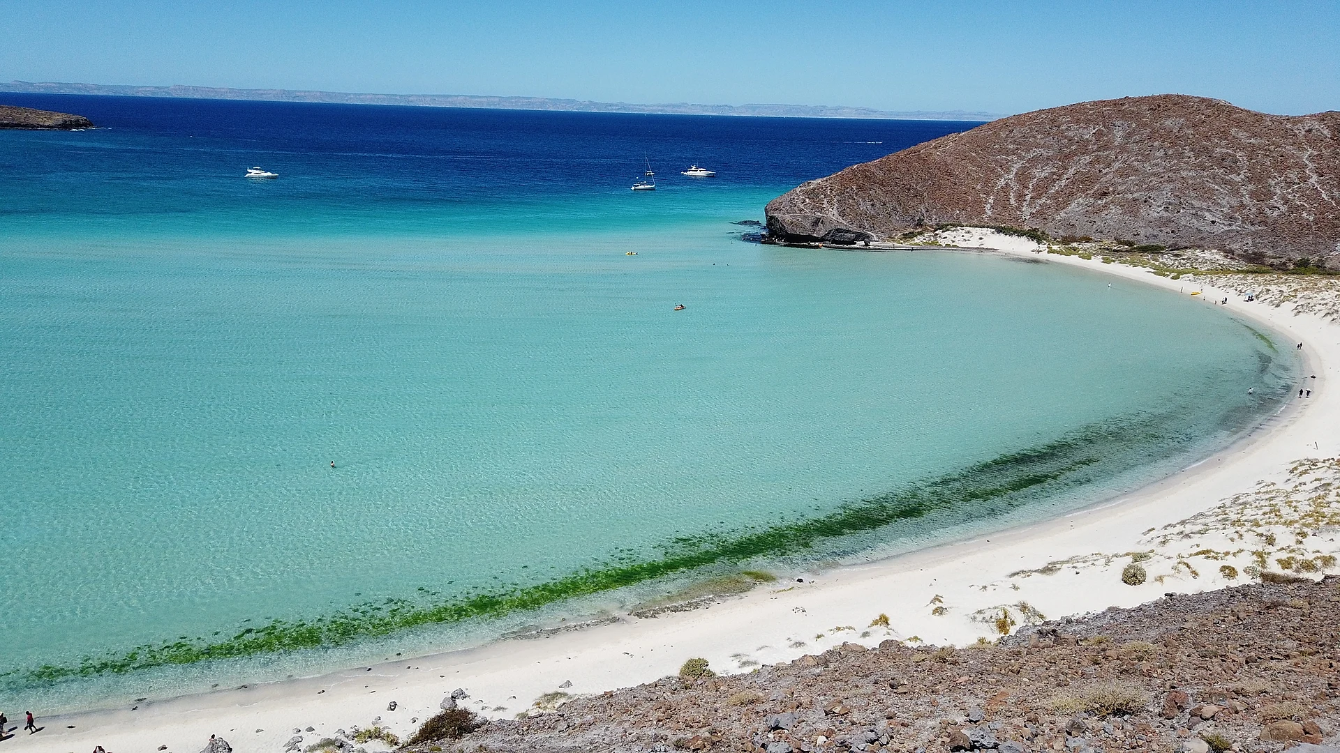
A wide, ankle-to-waist-deep turquoise lagoon and the El Hongo rock, now a protected area with a daily visitor cap and a wristband.
From La Paz: 30 min by car (24 km by road) How to get there ↓
Near here
See everything nearby ↓


Plan your visit to Playa Balandra
Where to stay near Playa Balandra
Compare hotels, posadas and guest houses in Playa Balandra.
Tours to Playa Balandra
Day trips and guided outings from Todos Santos often include Playa Balandra; with a local guide you can get there without a car.
 Isla Espíritu Santo and Balandra Beach Tour with Sea Lion Colony
★ 4.8 (18) · From US$99
How to get to Playa Balandra
- From La Paz: about 30 min by road (~24 km)
- Nearest airport: Los Cabos (SJD), 1 h 17 min by car to Todos Santos
Links open a partner site. We may earn a commission if you book, at no cost to you.
Popular tours to Playa Balandra


Tours, prices and ratings from Viator, checked weekly. We may earn a commission if you book.
About Playa Balandra
Playa Balandra is a bay on the Gulf of California side of the La Paz municipality, about 27 km north of the city of La Paz on the road that continues to Pichilingue and Playa El Tecolote. It is known for its shallow, very clear water that shades from pale green to turquoise, a long arc of white sand backed by low desert hills, and a small mushroom-shaped rock at the water's edge called El Hongo, which has become the area's best-known image. The bay is so shallow and sheltered that you can wade a long way out and the water stays warm, which makes it good for families with small children.
The bay and the mangroves behind it are protected as the Área de Protección de Flora y Fauna Balandra, decreed on 30 November 2012 and covering about 2,500 hectares of land and sea. The mangrove at the head of the bay is the largest inside the Bahía de La Paz, and the site is also listed as a Ramsar wetland. Because the beach had become very crowded, the authorities now regulate entry: visitors are admitted in two daily shifts, with a cap reported at 450 people each, and you get in with a digital wristband bought online through CONANP rather than by simply arriving. The system has been adjusted a few times since it began, so check the current rules before you plan a day around it.
There is little on the beach itself: no restaurants or services, and shade is limited, so people bring a hat, water, a cover-up and carry out what they bring in. Kayaks can be rented on the sand, and paddling or wading along the shore leads to the neighboring coves. Snorkeling is possible in the clearer parts of the bay, but the main pleasure is floating in the warm, calm water and walking the sandbars at low tide. El Hongo sits on the rocky point at the western end; climbing on it is discouraged because the rock is fragile, and the formation has been repaired after damage.
Balandra is a half-hour drive from the center of La Paz. Mornings are the quietest time, and the water is usually calmest then. October to March is the most comfortable season; summers are very hot and the shade-free beach is hard to take in the middle of the day.
How to get to Playa Balandra
Drive from La Paz: 30 min, 24 km
Balandra is about 27 km north of La Paz, roughly a 30-minute drive on the coastal road toward Pichilingue and Playa El Tecolote. Without a car, the public bus from the La Paz terminal goes most of the way and you walk a short distance to the bay; taxis and tour operators also go. Entry now goes through the CONANP wristband system, so reserve online before you set out.
Directions to Playa Balandra on Google Maps
Distances are in a straight line; the road is usually longer.
Links open a partner site. We may earn a commission if you book, at no cost to you.
From the nearest cities to Playa Balandra
- La Paz · 24 km by road, 30 min
- Cabo San Lucas · 183 km by road, 2 h 40 min
- San José del Cabo · 212 km by road, 3 h
Drive times by road from OpenStreetMap, without traffic or stops. Times marked ~ are estimated from the straight-line distance.
Before you go to Playa Balandra: hours, prices and tips
- Hours
- Entry is in two daily shifts: morning 8:00 to 12:00 and afternoon from 13:00; sources differ on whether the afternoon shift closes at 17:00 or 19:00, so check when you book. Food and Pleasure · checked Oct 2026
- Entry
- A digital wristband costs 120 pesos per person, bought online through CONANP; children under 12, people with disabilities and INAPAM card holders were reported exempt. Food and Pleasure · checked Oct 2026
- Rules
- A cap of about 450 visitors per shift applies. There are no restaurants on the beach and little shade; bring water, a hat and carry out your trash. Earth Vagabonds · checked Oct 2026
Hours and prices change, especially around holidays. Each fact links to where we checked it.
Visiting Playa Balandra: what to see and do
Wade and float in the shallow, warm lagoon.
Photograph El Hongo, the mushroom rock, from the shore without climbing on it.
Rent a kayak on the sand and paddle along the shore to nearby coves.
Snorkel in the clearer parts of the bay.
Walk the sandbars at low tide.
Stay for the changing colors of the water in the morning light.
Plan your trip
Places to stay in Playa Balandra
Compare hotels, posadas, and rentals in and around Playa Balandra.
Tours & activities
Day trips and guided outings from Todos Santos often include Playa Balandra; with a local guide you can get there without a car.
Rental cars
Pick up a car at SJD (Los Cabos): about 1 h 17 min by road to Todos Santos, then 97 km more to Playa Balandra, on your own schedule.
Flights
The nearest airport with scheduled flights is Los Cabos (SJD), about 1 h 17 min by road from Todos Santos, the base for Playa Balandra.
Travel insurance
If you plan on swimming or surfing at Playa Balandra, check that your policy covers it: some plans leave adventure activities out.
Mobile data
Signal can drop away from Todos Santos: download a map of the way to Playa Balandra before you set out, or carry an eSIM with data.
Links open a partner site. We may earn a commission if you book, at no cost to you.
Photos
When to go to Playa Balandra mild
Playa Balandra shares the climate of Todos Santos, 97 km away. The best months to visit are March, April, May, and December.
Playa Balandra is best for swimming and time on the water in the warmest months (July, August, and September); in the rainiest ones (August, September, and October) expect storms in the afternoon.
See the month-by-month climate of Todos Santos
Weather in Playa Balandra now and the next 7 days
Live forecast from Open-Meteo. Chance of rain is the day's highest.
The closest Pueblo Mágico: Todos Santos

Todos Santos is the Pueblo Mágico closest to Playa Balandra, with places to stay, food, and more to see.
Closest to Playa Balandra
-
Playa El Tecolote · Beach · 2 km away
-
Isla Espíritu Santo · Island · 17 km away
-
La Paz · City · 18 km away
-
Los Islotes · Island · 32 km away
Near Playa Balandra

Drive times by road from OpenStreetMap, without traffic. Times marked ~ are estimated from the straight-line distance.
Lists with Playa Balandra
Beaches in Baja California Sur · 12Location from OpenStreetMap. Written by Puebloteca.