

Island La Paz, Baja California Sur Municipality of La Paz La Paz Bay Islands of the Sea of Cortez
Uninhabited national park island north of La Paz: red cliffs, white beaches, kayaking, camping and the nearby sea lions of Los Islotes.
Reached by boat from La Paz: 1 h each way. How to get there ↓
Near here
See everything nearby ↓


Plan your visit to Isla Espíritu Santo
Where to stay near Isla Espíritu Santo
Compare hotels, posadas and guest houses in Isla Espíritu Santo.
Tours to Isla Espíritu Santo
Day trips and guided outings from Baja California Sur often include Isla Espíritu Santo; with a local guide you can get there without a car.
 Isla Espíritu Santo Tour
★ 4.8 (202) · From US$121
How to get to Isla Espíritu Santo
- Reached by boat from La Paz: 1 h each way.
- From Cabo San Lucas: about 2 h 15 min by road (~159 km)
Links open a partner site. We may earn a commission if you book, at no cost to you.
Popular tours to Isla Espíritu Santo


Tours, prices and ratings from Viator, checked weekly. We may earn a commission if you book.
About Isla Espíritu Santo
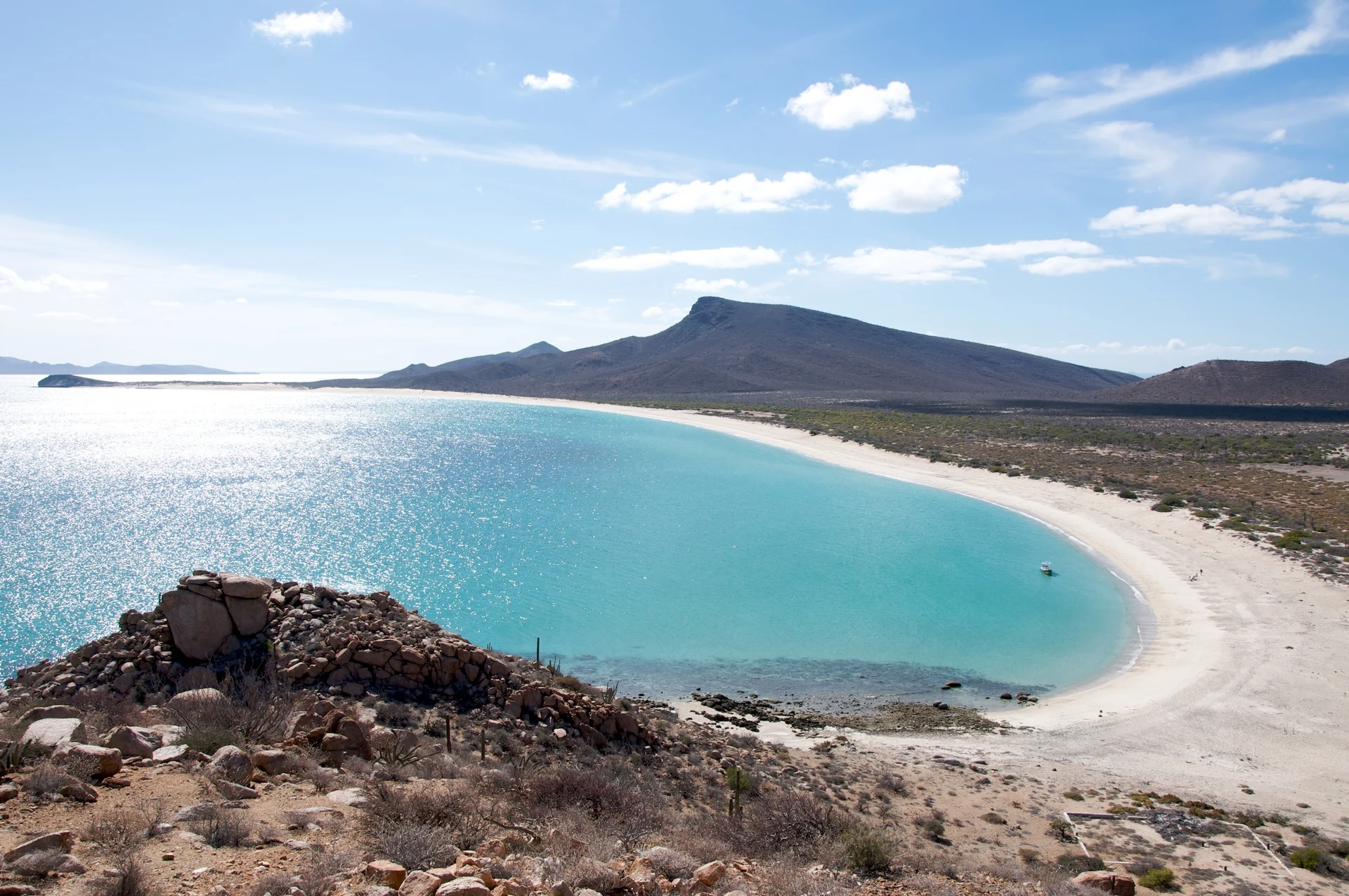
Isla Espíritu Santo lies in the Gulf of California about 26 km north of La Paz, in the La Paz municipality. It covers roughly 81 square kilometers, rises to about 560 m, and is separated from its smaller neighbor, Isla Partida, by a narrow channel that can be waded at some tides. Nobody lives on it. The shoreline alternates between red and ochre volcanic cliffs and small coves of pale sand and clear, turquoise water, with a dry-desert interior of cardón cacti and thorny scrub.
People have used these islands for a very long time: shell fishhooks from the Covacha Babisuri rock shelter date to about 8,700 years ago, and the Pericú fished and gathered here. In the twentieth century the island was a target of tourism developers, and in the 1990s a conservation coalition led by Tim Means helped buy out the land from the ejido that held it and donated it to the nation. The island group is part of the Islas del Golfo de California protected area, was recognized as a biosphere reserve in the 1990s, and is part of the UNESCO World Heritage listing of the Gulf of California islands from 2005. In 2007 the surrounding waters became the Archipiélago de Espíritu Santo National Park, covering about 480 square kilometers. The island is the only known home of the Espíritu Santo antelope squirrel and a black jackrabbit.
Most visitors come on a day trip by motor boat from La Paz or Playa El Tecolote, stopping to swim and snorkel in a few coves and often adding the sea lion colony at Los Islotes, off the island's northern tip. The reefs hold parrotfish, angelfish and wrasse, and there are pelicans, boobies and frigatebirds on the rocks. Ensenada Grande, on the neighboring Isla Partida, is the cove many operators single out for its beach. For a longer visit there are multi-day sea-kayak trips that circle the island and camp on a different beach each night, and there are tent camps with basic facilities, one of which operates from November to April. Operators supply the boat, snorkel gear and often lunch.
There are no services on the island, so water, sun protection and everything you carry in have to come back out with you. The park is regulated by CONANP, which manages access with entry wristbands or passes, and the rules have been under review, so confirm them with your operator or CONANP before going. Winds in the Gulf pick up in winter and can cancel crossings; summers are very hot.
How to get to Isla Espíritu Santo
Drive from Cabo San Lucas to La Paz: 2 h 15 min, 159 km
There is no bridge or ferry: the island is reached by boat, and most visitors go with a licensed tour operator out of La Paz or from Playa El Tecolote, on the road about 30 km north of the city, where the crossing is shorter. Operators supply the boat, snorkel gear and often lunch. Whale-shark and sea lion tours often include a stop here. From La Paz the boat ride usually takes about an hour, a little less on a calm day; ask the operator where they leave from.
Reached by boat from La Paz: 1 h each way.
Directions to Isla Espíritu Santo on Google Maps
Distances are in a straight line; the road is usually longer.
Links open a partner site. We may earn a commission if you book, at no cost to you.
From the nearest cities to Isla Espíritu Santo
- Cabo San Lucas · 159 km by road, 2 h 15 min to La Paz, then 1 h by boat
- San José del Cabo · 189 km by road, 2 h 35 min to La Paz, then 1 h by boat
- Guasave · about 315 km by road, ~4 h 40 min to La Paz, then 1 h by boat
Drive times by road from OpenStreetMap, without traffic or stops. Times marked ~ are estimated from the straight-line distance.
Before you go to Isla Espíritu Santo: hours, prices and tips
- Best season
- Winter winds can cancel crossings; the tent camp on the island operates November to April. Go La Paz · checked Oct 2026
- Guide or tour
- The island has no road or ferry; you reach it with a boat operator out of La Paz or El Tecolote, who normally provides the boat and snorkel gear. Tours: Viator GetYourGuide Wikipedia · checked Oct 2026
Hours and prices change, especially around holidays. Each fact links to where we checked it.
Visiting Isla Espíritu Santo: what to see and do
Swim and snorkel in the clear coves along the island's western shore.
Visit Ensenada Grande on Isla Partida for its beach.
Take a boat on to Los Islotes to see the sea lion colony.
Paddle a multi-day sea-kayak circuit and camp on a new beach each night.
Watch for pelicans, boobies, frigatebirds and reef fish.
Walk one of the island's trails for views over the water.
Plan your trip
Places to stay in Isla Espíritu Santo
Compare hotels, posadas, and rentals in and around Isla Espíritu Santo.
Tours & activities
Day trips and guided outings from Baja California Sur often include Isla Espíritu Santo; with a local guide you can get there without a car.
Mobile data
Signal can drop away from Baja California Sur: download a map of the way to Isla Espíritu Santo before you set out, or carry an eSIM with data.
Links open a partner site. We may earn a commission if you book, at no cost to you.
Photos
Closest to Isla Espíritu Santo
-
Playa El Tecolote · Beach · 15 km away
-
Los Islotes · Island · 16 km away
-
Playa Balandra · Beach · 17 km away
-
La Paz · City · 34 km away
Near Isla Espíritu Santo
-
Todos Santos · Pueblo Mágico · Baja California Sur
2 h 15 min: 1 h by boat back to La Paz, then drive



Drive times by road from OpenStreetMap, without traffic. Times marked ~ are estimated from the straight-line distance.
Location from OpenStreetMap. Written by Puebloteca.