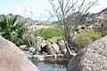

Hot springs Mexicali, Baja California Municipality of Mexicali
A blue-palm oasis with 52 °C spring water piped into private tubs, in the Sierra de Juárez at the end of a dirt road across the Laguna Salada.
From Mexicali: about 1 h 10 min by road (~80 km) How to get there ↓
Near here
See everything nearby ↓

Plan your visit to Cañón de Guadalupe
Where to stay near Cañón de Guadalupe
Compare hotels, posadas and guest houses in Cañón de Guadalupe.
Tours to Cañón de Guadalupe
Day trips and guided outings from Tecate often include Cañón de Guadalupe; with a local guide you can get there without a car.
 Tours from Ensenada
Las Cañadas Zipline Tour (with Luxury Roundtrip Transportation)
★ 4.9 (407) · From US$77
How to get to Cañón de Guadalupe
- From Mexicali: about 1 h 10 min by road (~80 km)
- Nearest airport: Tijuana (TIJ), 40 min by car to Tecate
Links open a partner site. We may earn a commission if you book, at no cost to you.
Tours from Ensenada, near Cañón de Guadalupe


Tours, prices and ratings from Viator, checked weekly. We may earn a commission if you book.
About Cañón de Guadalupe
Cañón de Guadalupe cuts into the eastern face of the Sierra de Juárez on the western edge of the Laguna Salada dry lake, in Mexicali municipality, at about 400 meters. A stream comes down from the range between granite boulders and feeds thousands of palms, among them the blue fan palm (Brahea armata), making a true desert oasis. On the north side of the canyon an alkaline spring flows at 52 °C, around 125,000 gallons a day, and channels carry it to pools of rock and concrete; at times hot and cold water run almost side by side.
The Cucapá people used the springs long before ranchers arrived. Around 1940 cattleman José Loya Murillo came upon the spring and palm grove while hunting strays with his sons; by about 1958 he had moved into the canyon and built the first tubs, and a road reached it in the early 1960s. Mystery writer Erle Stanley Gardner wrote about camping here in 1968. Don José died in 1997 at 99, and his family still runs the camps.
This is not a drop-in spa. The land is private and works as a reserved campground: each site has a palapa, a table, a grill and its own hot tub fed from the spring. Up-canyon are waterfalls and cool pools for swimming, and near the entrance there are petroglyphs, potsherds and a cave once used by the canyon's early people. Bighorn sheep, foxes and eagles live in the surrounding hills. From June to September temperatures often pass 45 °C and the camps close, so the season runs from autumn to spring.
How to get to Cañón de Guadalupe
From Mexicali, the nearest city, it is 2 h 45 min and 90 km by road. Take Federal Highway 2 toward Tijuana; at Km 28, at the foot of the La Rumorosa grade, a graded dirt road signed "Cañón de Guadalupe" leaves to the south for about 52 km. A second turn-off at Km 24, signed "Laguna Salada", crosses the dry lakebed and joins the graded road a few kilometers before the canyon; skip it after rain or if there is standing water. The last 3 to 5 km are steep and rocky, so bring a pickup or high-clearance SUV, and 4x4 if it has rained. Tecate, the nearest Pueblo Mágico, is 3 h 35 min and 153 km away, down La Rumorosa on Highway 2. There is no public transport and no fuel on the way; fill up in Mexicali or La Rumorosa. Some travel agencies offer transport.
Directions to Cañón de Guadalupe on Google Maps
Distances are in a straight line; the road is usually longer.
Links open a partner site. We may earn a commission if you book, at no cost to you.
From the nearest cities to Cañón de Guadalupe
- Mexicali · about 80 km by road, ~1 h 10 min
- Ensenada · about 110 km by road, ~1 h 35 min
- Tecate · about 120 km by road, ~1 h 45 min
Drive times by road from OpenStreetMap, without traffic or stops. Times marked ~ are estimated from the straight-line distance.
Before you go to Cañón de Guadalupe: hours, prices and tips
- Entry
- You pay per campsite per night, in US dollars: Guadalupe Canyon Oasis lists tub sites from about US$55 on weekdays to US$160 at weekends for the largest. Book and pay before you arrive. Guadalupe Canyon Oasis · checked Oct 2026
- Best season
- Closes in summer for the extreme heat (June to September) and reopens in autumn; it reopened in October 2025 after the summer. El Imparcial · checked Oct 2026
- What to bring
- Food for every meal, drinking water, ice, a gas stove, tent, sleeping bags and blankets, lanterns and a full tank: there is no fuel and no cell signal in the canyon. Guadalupe Canyon Oasis · checked Oct 2026
- Rules
- Reservation only. No music at the camps, and you pack out your trash. México Desconocido Escapadas · checked Oct 2026
Hours and prices change, especially around holidays. Each fact links to where we checked it.
Visiting Cañón de Guadalupe: what to see and do
The private hot tubs at each campsite
The blue fan palm grove on the canyon floor
The waterfalls and cool pools up-canyon
The petroglyphs and rock paintings along the trails
The early people's cave and the mud bath
The view over the Laguna Salada at sunset
The night sky for stargazing
Plan your trip
Places to stay in Cañón de Guadalupe
Compare hotels, posadas, and rentals in and around Cañón de Guadalupe.
Tours & activities
Day trips and guided outings from Tecate often include Cañón de Guadalupe; with a local guide you can get there without a car.
Rental cars
Pick up a car at TIJ (Tijuana): about 40 min by road to Tecate, then 92 km more to Cañón de Guadalupe, on your own schedule.
Flights
The nearest airport with scheduled flights is Tijuana (TIJ), about 40 min by road from Tecate, the base for Cañón de Guadalupe.
Travel insurance
If you plan on soaking in the pools at Cañón de Guadalupe, check that your policy covers it: some plans leave adventure activities out.
Mobile data
Signal can drop away from Tecate: download a map of the way to Cañón de Guadalupe before you set out, or carry an eSIM with data.
Links open a partner site. We may earn a commission if you book, at no cost to you.
When to go to Cañón de Guadalupe mild
Cañón de Guadalupe shares the climate of Tecate, 92 km away. The best months to visit are May, June, September, and October.
Warm water feels best when the nights are coldest here (January, February, and March), and those are also the busiest weekends at Cañón de Guadalupe.
See the month-by-month climate of Tecate
Weather in Cañón de Guadalupe now and the next 7 days
Live forecast from Open-Meteo. Chance of rain is the day's highest.
The closest Pueblo Mágico: Tecate

Tecate is the Pueblo Mágico closest to Cañón de Guadalupe, with places to stay, food, and more to see.
Closest to Cañón de Guadalupe
-
Parque Nacional Constitución de 1857 · Nature reserve · 12 km away
-
La Rumorosa · Town · 48 km away
-
Ejido Cucapah Indígena · Village · 49 km away
Near Cañón de Guadalupe
-
Mexicali · City
~1 h 10 min drive · 63 km





Drive times by road from OpenStreetMap, without traffic. Times marked ~ are estimated from the straight-line distance.
Location from OpenStreetMap. Written by Puebloteca.