
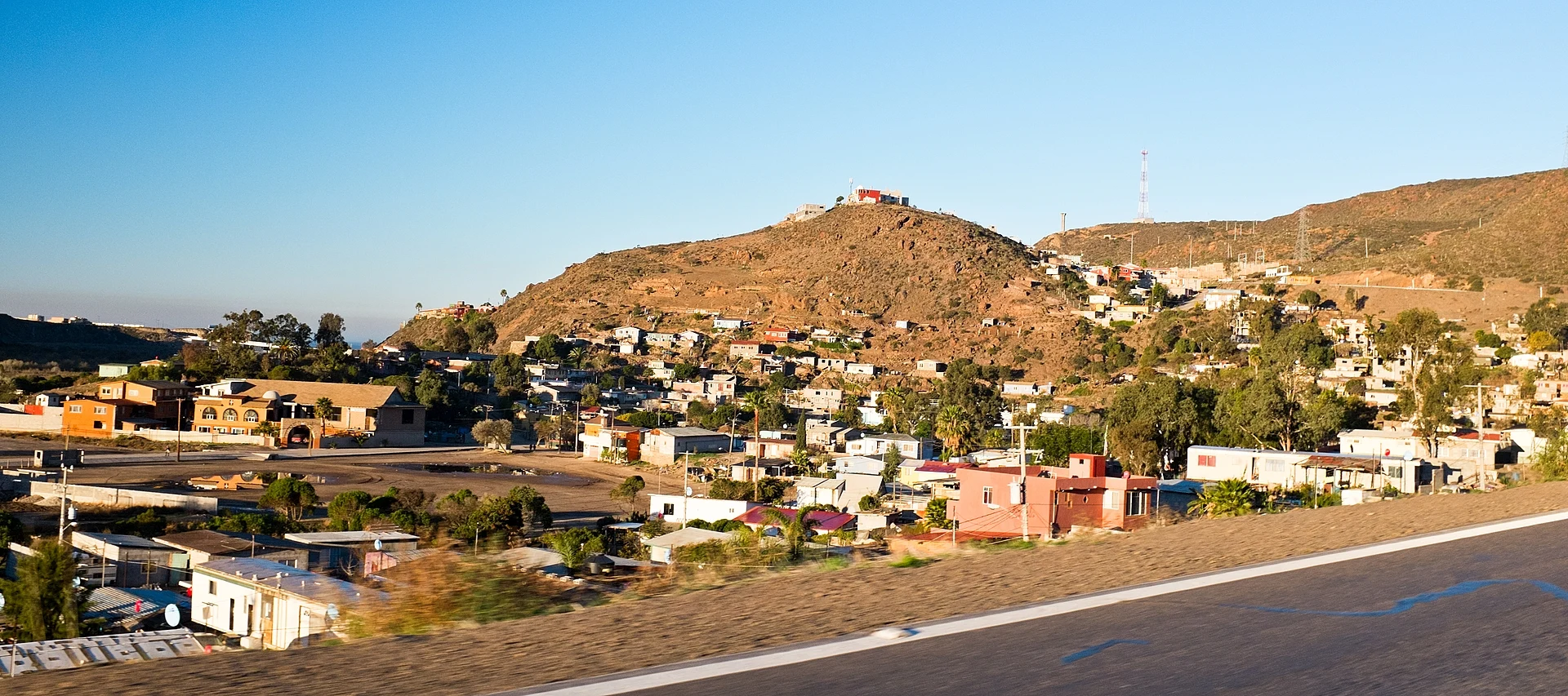
Village Ensenada, Baja California Municipality of Ensenada
Coastal ejido between Rosarito and Ensenada: a wide beach below the bluff, the Guadalupe River estuary and horseback rides on the sand.
From Ensenada: about 40 min by road (~45 km) How to get there ↓
Near here
See everything nearby ↓


Plan your visit to La Misión
Where to stay near La Misión
Compare hotels, posadas and guest houses in La Misión.
Tours to La Misión
Day trips and guided outings from Tecate often include La Misión; with a local guide you can get there without a car.
 Authentic horseback riding in beautiful La Mision
★ 5.0 (127) · From US$115
How to get to La Misión
- From Ensenada: about 40 min by road (~45 km)
- Nearest airport: Tijuana (TIJ), 40 min by car to Tecate
Links open a partner site. We may earn a commission if you book, at no cost to you.
Popular tours to La Misión
Tours, prices and ratings from Viator, checked weekly. We may earn a commission if you book.
About La Misión
La Misión is an ejido and borough of Ensenada municipality, about 40 km north of the port, at the point where the free road leaves the coast and heads inland up a valley between two hills. It counted just over 1,100 residents in the 2020 census, spread between houses on the hillsides, farmland on the valley floor and homes along the bluff above the Pacific.
Below the bluff lies Playa La Misión, a broad sandy beach with surf loud enough to hear from the rooftops. People walk it, swim and ride horses along it; local outfits run rides on the sand and others across the valley into the hills. Next to it the San Juan Bautista creek, also called the Río Guadalupe, reaches the sea and spreads into an estuary of marsh, white herons and wild ducks. Around 250 bird species use the estuary and the slopes around it, and September and November are good months to photograph them. Beside the estuary is a palm-shaded campground with a pool, and vacation rentals line the beach and the bluff.
The village takes its name from the Dominican mission of San Miguel Arcángel de la Frontera, founded in 1787, whose adobe ruins stand in the center. In 1862 Felipe Crosthwaite bought 7,500 hectares from the government and called the place Rancho La Misión Vieja de San Miguel; the ejido followed in 1937. The calabaceado, the folk dance of northern Baja California, took shape in this area, and every year in the last week of May the Fiestas de La Misión, held since 1979, bring food, folk dance, music and religious events. The old road east to the Valle de Guadalupe wineries also starts here. Rain is scarce, roughly 250 to 285 mm a year and mostly in winter; summers are dry, and from September to April the sky is usually clear of coastal fog.
How to get to La Misión
Ensenada, the nearest city, is 45 min and 43 km away by road; Tecate, the nearest Pueblo Mágico, is 1 h 15 min and 88 km. From Tijuana and Rosarito, drive south on the Scenic toll road (Federal Highway 1D) and take the Alisitos exit near km 59.5, signed for La Fonda; at the stop sign turn left toward Ensenada, and about a mile on the free road (Federal Highway 1) turns inland through La Misión. Watch for speed bumps in the village. On to Ensenada, the free road is two lanes, steep and winding in places with no shoulder, as far as San Miguel; or go back to the toll road. We found no bus line with a set stop in La Misión, so plan on driving.
Directions to La Misión on Google Maps
Distances are in a straight line; the road is usually longer.
Links open a partner site. We may earn a commission if you book, at no cost to you.
From the nearest cities to La Misión
- Ensenada · about 45 km by road, ~40 min
- Tijuana · about 70 km by road, ~1 h
- Tecate · about 75 km by road, ~1 h 5 min
Drive times by road from OpenStreetMap, without traffic or stops. Times marked ~ are estimated from the straight-line distance.
Before you go to La Misión: hours, prices and tips
- Best season
- Fiestas de La Misión in the last week of May. September to April has less fog; September and November are good for birds in the estuary. Wikipedia; Baja Bound · checked Oct 2026
Hours and prices change, especially around holidays. Each fact links to where we checked it.
Visiting La Misión: what to see and do
Playa La Misión, broad and sandy
The Río Guadalupe estuary and its birds
Horseback rides on the beach or across the valley
The San Miguel mission ruins in the village center
The Fiestas de La Misión in the last week of May
The old road east to the Valle de Guadalupe
Plan your trip
Places to stay in La Misión
Compare hotels, posadas, and rentals in and around La Misión.
Tours & activities
Day trips and guided outings from Tecate often include La Misión; with a local guide you can get there without a car.
Rental cars
Pick up a car at TIJ (Tijuana): about 40 min by road to Tecate, then 57 km more to La Misión, on your own schedule.
Flights
The nearest airport with scheduled flights is Tijuana (TIJ), about 40 min by road from Tecate, the base for La Misión.
Mobile data
Signal can drop away from Tecate: download a map of the way to La Misión before you set out, or carry an eSIM with data.
Links open a partner site. We may earn a commission if you book, at no cost to you.
When to go to La Misión mild
La Misión shares the climate of Tecate, 57 km away. The best months to visit are May, June, September, and October.
See the month-by-month climate of Tecate
Weather in La Misión now and the next 7 days
Live forecast from Open-Meteo. Chance of rain is the day's highest.
The closest Pueblo Mágico: Tecate

Tecate is the Pueblo Mágico closest to La Misión, with places to stay, food, and more to see.
Closest to La Misión
-
Misión San Miguel Arcángel de la Frontera · Archaeological site · 0 km away
-
Misión El Descanso · Village · 14 km away
-
Puerto Nuevo · Village · 18 km away
-
San Antonio de las Minas · Village · 23 km away
-
Valle de Guadalupe · Nature reserve · 25 km away
-
Francisco Zarco · Village · 26 km away
-
Ensenada · City · 35 km away
-
La Bufadora · Landmark · 43 km away


Near La Misión



Drive times by road from OpenStreetMap, without traffic. Times marked ~ are estimated from the straight-line distance.
Location from OpenStreetMap. Written by Puebloteca.