Lake Lerdo, Durango La Laguna
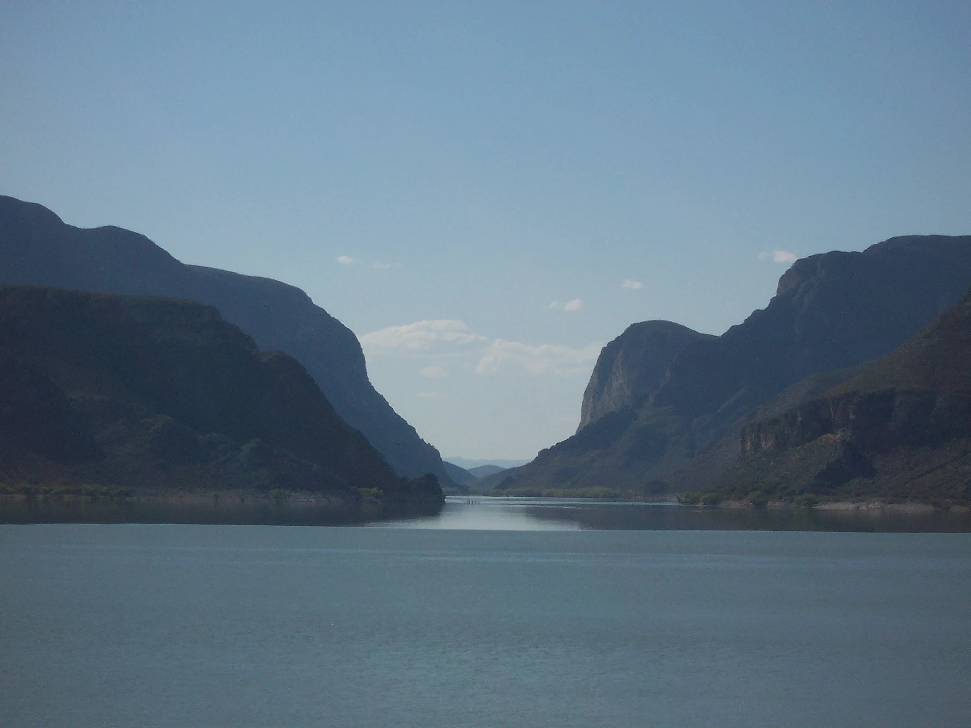
Las Tórtolas reservoir holds back the Nazas between limestone walls west of Lerdo: bass fishing, sport climbing and Fernández Canyon just downstream.
From Torreón: about 55 min by road (~60 km) How to get there ↓
Near here
See everything nearby ↓


Plan your visit to Presa Francisco Zarco
Where to stay near Presa Francisco Zarco
Compare hotels, posadas and guest houses in Presa Francisco Zarco.
Tours to Presa Francisco Zarco
Day trips and guided outings from Mapimí often include Presa Francisco Zarco; with a local guide you can get there without a car.
How to get to Presa Francisco Zarco
- From Torreón: about 55 min by road (~60 km)
- Nearest airport: Torreón (TRC), 1 h 16 min by car to Mapimí
Links open a partner site. We may earn a commission if you book, at no cost to you.
About Presa Francisco Zarco
Hardly anyone in La Laguna calls it Francisco Zarco; to locals it is Las Tórtolas. The dam blocks the Nazas River in Lerdo municipality, at the point where the river leaves the mountains through a limestone gorge. It is the lower of the two big reservoirs that water the Comarca Lagunera: upstream sits the much larger Lázaro Cárdenas dam, known as El Palmito, and Las Tórtolas regulates what comes down from it and hands it out for irrigation and the region's water supply. It holds about 380 million cubic metres. In September 2022 it reached 100 percent of its normal level and the water authority opened the gates, sending 100 cubic metres a second down the usually dry bed of the Nazas.
Filling the reservoir drowned the old village of Graceros, whose people moved to Nuevo Graceros, the settlement the dam road now runs through. When the water is low, the tower of the old church sometimes shows above the surface. Past the village the road goes through two rock tunnels to the shore, where there are restaurants, weekend houses and fishing clubs.
The water holds mojarra, largemouth bass, catfish, robaleta and carp. A fishing cooperative has worked the reservoir since the 1980s, and bass tournaments are held here on a catch-and-release basis. The limestone cliffs around the lake are also a sport-climbing area, with some 60 bolted routes on walls such as El Reliz de los Venados, whose east face carries rock paintings that climbers are asked to leave alone.
Below the dam begins Cañón de Fernández State Park, a Ramsar wetland since 2008 covering 17,001 hectares, where the Nazas runs between bald cypresses and more paintings mark the rocks. When the dam releases water, Lerdo's civil protection office patrols the riverside picnic spots and asks people not to swim.
How to get to Presa Francisco Zarco
From Torreón it is 83 km, about 1 h 15 min by car. Head west on Highway 40 through Gómez Palacio, then take the 49D toll road toward Cuencamé and Zacatecas; after about 41 km comes the signposted exit for the dam. From there about 10 km of paved road runs through Nuevo Graceros and two rock tunnels to the shore. On weekends and in high season the ejido charges a small fee at a booth on the access road. Coming from Zacatecas, follow the 49D north past Cuencamé. No bus goes to the dam: drive, or take a taxi from Lerdo or Gómez Palacio. Mapimí, the nearest Pueblo Mágico, is 132 km away by road, about 1 h 55 min.
Directions to Presa Francisco Zarco on Google Maps
Distances are in a straight line; the road is usually longer.
Links open a partner site. We may earn a commission if you book, at no cost to you.
From the nearest cities to Presa Francisco Zarco
- Torreón · about 60 km by road, ~55 min
- Durango · about 215 km by road, ~3 h 10 min
- Fresnillo · about 325 km by road, ~4 h 50 min
Drive times by road from OpenStreetMap, without traffic or stops. Times marked ~ are estimated from the straight-line distance.
Before you go to Presa Francisco Zarco: hours, prices and tips
- Entry
- On weekends and in high season the Graceros ejido charges a small per-car fee at the booth on the dam road. Mountain Project · checked Oct 2026
- Best time of day
- Los Sabinos and Las Ventanas are hard to reach from April to August, when the dam releases more water for irrigation; El Reliz de los Venados can be reached all year. Mountain Project · checked Oct 2026
- Rules
- When the dam opens its gates, Lerdo's civil protection office asks people not to swim in the Nazas or enter the wetlands. Emergencies: 911. El Siglo de Torreón · checked Oct 2026
Hours and prices change, especially around holidays. Each fact links to where we checked it.
Visiting Presa Francisco Zarco: what to see and do
Eat ceviche or fish at the lakeside restaurants.
Fish for bass, catfish or mojarra from a boat.
Climb the bolted routes of El Reliz de los Venados and Los Sabinos.
Look for the old Graceros church tower when the water is low.
Drive the two tunnels between Nuevo Graceros and the dam wall.
Walk among bald cypresses in Fernández Canyon, below the dam.
Look at the rock paintings without touching them.
Plan your trip
Places to stay in Presa Francisco Zarco
Compare hotels, posadas, and rentals in and around Presa Francisco Zarco.
Tours & activities
Day trips and guided outings from Mapimí often include Presa Francisco Zarco; with a local guide you can get there without a car.
Rental cars
Pick up a car at TRC (Torreón): about 1 h 16 min by road to Mapimí, then 63 km more to Presa Francisco Zarco, on your own schedule.
Flights
The nearest airport with scheduled flights is Torreón (TRC), about 1 h 16 min by road from Mapimí, the base for Presa Francisco Zarco.
Travel insurance
If you plan on swimming or kayaking at Presa Francisco Zarco, check that your policy covers it: some plans leave adventure activities out.
Mobile data
Signal can drop away from Mapimí: download a map of the way to Presa Francisco Zarco before you set out, or carry an eSIM with data.
Links open a partner site. We may earn a commission if you book, at no cost to you.
When to go to Presa Francisco Zarco mild
Presa Francisco Zarco shares the climate of Mapimí, 63 km away. The best months to visit are January, March, April, and December.
Presa Francisco Zarco is best for swimming and time on the water in the warmest months (May, June, and July); in the rainiest ones (July, August, and September) expect storms in the afternoon.
See the month-by-month climate of Mapimí
Weather in Presa Francisco Zarco now and the next 7 days
Live forecast from Open-Meteo. Chance of rain is the day's highest.
The closest Pueblo Mágico: Mapimí

Mapimí is the Pueblo Mágico closest to Presa Francisco Zarco, with places to stay, food, and more to see.
Closest to Presa Francisco Zarco
-
Velardeña · Village · 23 km away
-
Cuencamé · Town · 45 km away
-
Grutas del Rosario · Cave · 45 km away
Near Presa Francisco Zarco


Drive times by road from OpenStreetMap, without traffic. Times marked ~ are estimated from the straight-line distance.
Lists with Presa Francisco Zarco
Lakes and Lagoons in Durango · 3Location from OpenStreetMap. Written by Puebloteca.