
Village Villa Corona, Jalisco Municipality of Villa Corona
Villa Corona delegation with an 1890 ex-hacienda, dams and canals and a Cristo Rey fiesta in November; 10 km from Cocula.
From Guadalajara: 1 h 5 min by car (67 km by road) How to get there ↓
Near here
See everything nearby ↓



Plan your visit to Estipac
Where to stay near Estipac
Compare hotels, posadas and guest houses in Estipac.
Tours to Estipac
Day trips and guided outings from Cocula often include Estipac; with a local guide you can get there without a car.
 Tours from Guadalajara
Full Day Tour to Tequila and Amatitán with Fun and Culture
★ 4.9 (751) · From US$44
How to get to Estipac
- From Guadalajara: about 1 h 5 min by road (~67 km)
- Nearest airport: Guadalajara (GDL), 1 h 14 min by car to Cocula
Links open a partner site. We may earn a commission if you book, at no cost to you.
Tours from Guadalajara, near Estipac


Tours, prices and ratings from Viator, checked weekly. We may earn a commission if you book.
About Estipac
Estipac is one of the main localities of Villa Corona municipality, at roughly 1,370 metres above sea level, and the 2020 census counted 2,654 people. It was first called San José de Estipac after the hacienda that gave rise to the settlement. Local accounts say these lands belonged to the Coca people, whose main centre was present-day Cocula, and that Estipac means 'arid land' in their language. Residents are called estipactitas.
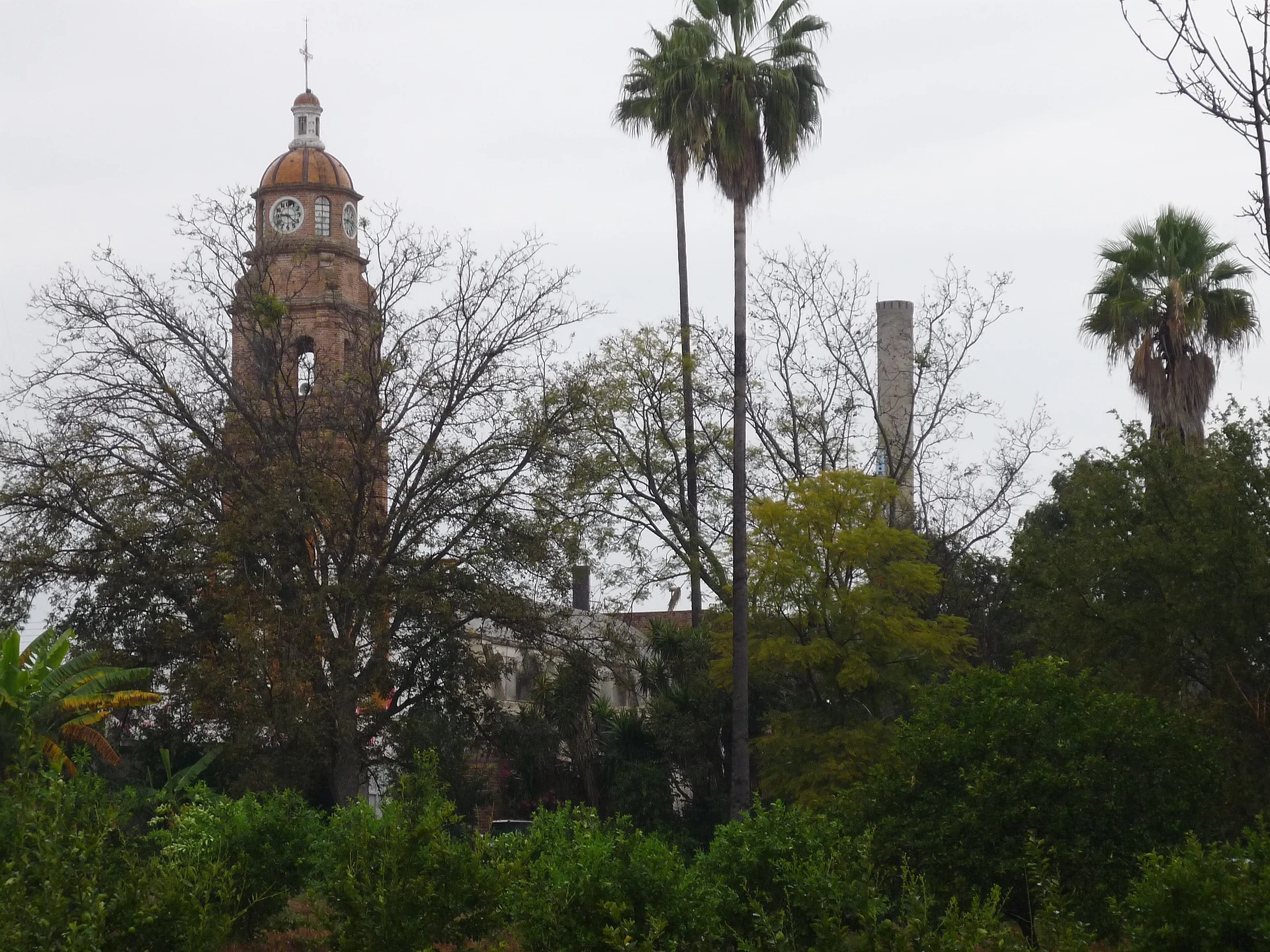
The hacienda still shapes the town: the main house of the ex-hacienda, built in 1890, survives as ruins, with a swimming pool used mostly privately and a tall chimney that shows above the trees beside the church bell tower. The novelist Susana Corcuera, whose family owned the estate, describes it in her writing as a model hacienda with irrigation systems. The town is known for its network of dams and canals: La Cañada, El Molino, El Montenegro, La Ciénega, Las Tusas and El Tecuán, plus an artesian well, which water an economy of farming and livestock with maize, sugarcane, sorghum, chickpeas, wheat and blue agave, and cattle and goats.
The main church is the Templo de Cristo Rey, and its fiesta is held in November. The climate is semi-dry and semi-warm, averaging about 20.5 °C, with rain concentrated in June, July and August; May and June are the hottest months.
How to get to Estipac
Drive from Guadalajara: 1 h 5 min, 67 km
Estipac is about 60 km from Guadalajara, 8 km from the municipal seat Villa Corona, 10 km from Cocula, 6 km from Atotonilco el Bajo and 1 km from Juan Gil Preciado. By car from Guadalajara, take federal highway 54 toward Acatlán de Juárez, then the turnoff for Villa Corona and Cocula on highway 8; Estipac lies on that route before Cocula. There is no direct bus from Guadalajara to Villa Corona: Sur de Jalisco runs from the Nueva Central Camionera to Acatlán de Juárez (about 40 minutes, every three hours according to Rome2rio), and from there you continue by local transport or taxi. Confirm schedules before you go.
Directions to Estipac on Google Maps
Distances are in a straight line; the road is usually longer.
Links open a partner site. We may earn a commission if you book, at no cost to you.
From the nearest cities to Estipac
- Guadalajara · 67 km by road, 1 h 5 min
- Ciudad Guzmán · 93 km by road, 1 h 30 min
- Ocotlán · 116 km by road, 1 h 40 min
Drive times by road from OpenStreetMap, without traffic or stops. Times marked ~ are estimated from the straight-line distance.
Before you go to Estipac: hours, prices and tips
- Best season
- Cristo Rey fiesta in November. Rain falls in June, July and August. Wikipedia (Municipio de Villa Corona) · checked Oct 2026
Hours and prices change, especially around holidays. Each fact links to where we checked it.
Visiting Estipac: what to see and do
The church bell tower, rising above the trees.
The ruins of the 1890 ex-hacienda of Estipac and its chimney.
The Templo de Cristo Rey, with its November fiesta.
The town's dams and canals: El Tecuán, Las Tusas, La Cañada.
The Laguna de Atotonilco, 6 km away by Atotonilco el Bajo.
Plan your trip
Places to stay in Estipac
Compare hotels, posadas, and rentals in and around Estipac.
Tours & activities
Day trips and guided outings from Cocula often include Estipac; with a local guide you can get there without a car.
Rental cars
Pick up a car at GDL (Guadalajara): about 1 h 14 min by road to Cocula, then 10 km more to Estipac, on your own schedule.
Flights
The nearest airport with scheduled flights is Guadalajara (GDL), about 1 h 14 min by road from Cocula, the base for Estipac.
Mobile data
Signal can drop away from Cocula: download a map of the way to Estipac before you set out, or carry an eSIM with data.
Links open a partner site. We may earn a commission if you book, at no cost to you.
When to go to Estipac mild
Estipac shares the climate of Cocula, 10 km away. The best months to visit are January, February, November, and December.
See the month-by-month climate of Cocula
Weather in Estipac now and the next 7 days
Live forecast from Open-Meteo. Chance of rain is the day's highest.
The closest Pueblo Mágico: Cocula

Cocula is the Pueblo Mágico closest to Estipac, with places to stay, food, and more to see.
Also close to
- Tapalpa · Jalisco · 47 km away
- Ajijic · Jalisco · 49 km away
- Tlaquepaque · Jalisco · 53 km away
- Sayula · Jalisco · 55 km away
- Tequila · Jalisco · 59 km away
Closest to Estipac
-
Atotonilco el Bajo · Village · 6 km away
-
Hacienda San Diego · Landmark · 9 km away
-
Villa Corona · Hot springs · 9 km away
-
Hacienda La Sauceda · Landmark · 13 km away
-
Barranca de Santa Clara · Village · 14 km away
-
Acatlán de Juárez · Town · 15 km away
-
San Martín Hidalgo · Town · 23 km away
-
Atemajac de Brizuela · Town · 25 km away


Near Estipac


Drive times by road from OpenStreetMap, without traffic. Times marked ~ are estimated from the straight-line distance.
Location from OpenStreetMap. Written by Puebloteca.