Town San Martín de Bolaños, Jalisco
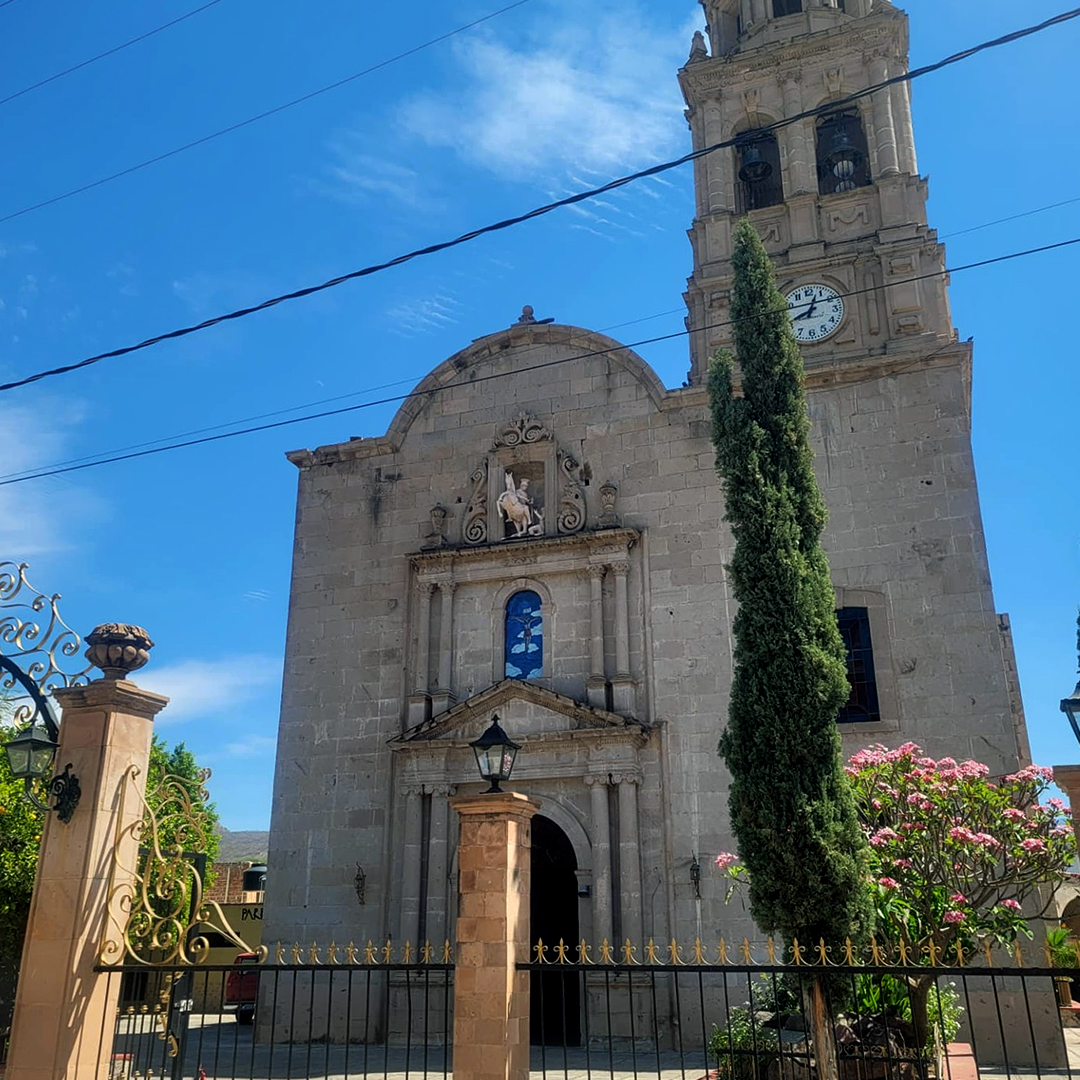
Seat in the Bolaños river canyon, with the neoclassical church of the Señor de Santa Rosa and a pre-Hispanic shaft tomb on Cerro del Piñón.
From Tepic: about 2 h 10 min by road (~145 km) How to get there ↓
Near here
See everything nearby ↓



Plan your visit to San Martín de Bolaños
Where to stay near San Martín de Bolaños
Compare hotels, posadas and guest houses in San Martín de Bolaños.
Tours to San Martín de Bolaños
Day trips around Teúl de González Ortega sometimes stop in San Martín de Bolaños; a tour is the easy way to see it without a car.
How to get to San Martín de Bolaños
- From Tepic: about 2 h 10 min by road (~145 km)
- Nearest airport: Guadalajara (GDL), 2 h 22 min by car to Teúl de González Ortega
Links open a partner site. We may earn a commission if you book, at no cost to you.
About San Martín de Bolaños
San Martín de Bolaños is the seat of the municipality of the same name in northern Jalisco, at about 800 metres above sea level inside the Bolaños river canyon. It had 2,138 residents at the 2020 census, out of 3,095 in the whole municipality. The name pairs the patron saint, Martin of Tours, with that of Toribio de Bolaños, who founded several settlements in the region.
The area has a long history before the Spanish. About 1,700 years ago groups arrived in the canyon, mixed with the people already living there and built villages on the mesas, from where they watched the river crossing and the trade route toward Chalchihuites. On the mesa of Cerro del Piñón, next to the town, archaeologists found a shaft tomb that was still sealed and undisturbed, dated to about AD 440. Inside were the bones of children and adults, large jars holding partly cremated remains, and marine shell beads brought from the Gulf of Guayaquil in Ecuador.
In 1530 Cristóbal de Oñate conquered the region on the orders of Nuño de Guzmán. A hacienda was later founded to process the ore from local deposits, and in the 17th century the place became part of the Alcaldía Mayor of Real de Bolaños. Around 1748 more Spaniards arrived, drawn by the silver of mines such as Espíritu Santo, El Parián, Barranco, La Castellana and La Perla. By 1825 San Martín was listed as a town with its own council; the municipality was suppressed in 1872 and restored in 1892.
The centre keeps the neoclassical 19th-century church of the Señor de Santa Rosa, with a two-tier façade and a bell tower. The Christ image venerated there is said to have come from Barcelona in colonial times. The Palacio Municipal dates from 1909 and belonged to Luis Ureña, one of the richest hacendados of his day. Local crafts include saddlery and saddles and belts decorated with pita (agave fibre) embroidery, and the local table offers pozole, tamales and enchiladas, with pitahaya honey and mezcal.
How to get to San Martín de Bolaños
San Martín de Bolaños is in northern Jalisco, about 200 km from Guadalajara by road (rutadistancia.com.mx gives 203 km and roughly 3 h 40 min by car). The Enciclopedia de los Municipios lists the long-distance road as Guadalajara–Colotlán–San Martín de Bolaños; from Guadalajara drivers head out toward Tesistán and federal highway 23 to Colotlán, and the last stretch into the Bolaños canyon is mountain road. Public buses run, but there are no official published schedules: route planners mention Rojo de los Altos, part of the Estrella Blanca group, from Guadalajara's Nueva Central Camionera, with connections and few departures a day, so confirm at the ticket office. From Teúl de González Ortega it is about 44 km (about 50 min), and from Tepic about 113 km (about 2 h).
Directions to San Martín de Bolaños on Google Maps
Distances are in a straight line; the road is usually longer.
Links open a partner site. We may earn a commission if you book, at no cost to you.
From the nearest cities to San Martín de Bolaños
- Tepic · about 145 km by road, ~2 h 10 min
- San Juan de los Lagos · about 210 km by road, ~3 h 5 min
- Guadalajara · 205 km by road, 3 h 55 min
Drive times by road from OpenStreetMap, without traffic or stops. Times marked ~ are estimated from the straight-line distance.
Before you go to San Martín de Bolaños: hours, prices and tips
- Best season
- Fiestas of the Señor de Santa Rosa, culminating 30 August; Virgen de Guadalupe, 12 December; Santa Cruz, 3 May; Independence Day, 16 September. Enciclopedia de los Municipios de México (INAFED) · checked Oct 2026
Hours and prices change, especially around holidays. Each fact links to where we checked it.
Visiting San Martín de Bolaños: what to see and do
Templo del Señor de Santa Rosa: a neoclassical 19th-century church with a two-tier façade and a tower.
Palacio Municipal, built in 1909 as the home of the hacendado Luis Ureña.
Museo Antropológico, with objects from the region's pre-Hispanic past.
Cerro del Piñón: the archaeological site where the sealed shaft tomb was found.
La Condesa chapel, where tradition says the Spanish gathered to venerate the Señor de Santa Rosa.
Saddlery and pita-decorated saddles, the town's best-known craft.
Plan your trip
Places to stay in San Martín de Bolaños
Compare hotels, posadas, and rentals in and around San Martín de Bolaños.
Tours & activities
Day trips around Teúl de González Ortega sometimes stop in San Martín de Bolaños; a tour is the easy way to see it without a car.
Rental cars
Pick up a car at GDL (Guadalajara): about 2 h 22 min by road to Teúl de González Ortega, then 44 km more to San Martín de Bolaños, on your own schedule.
Flights
The nearest airport with scheduled flights is Guadalajara (GDL), about 2 h 22 min by road from Teúl de González Ortega, the base for San Martín de Bolaños.
Mobile data
Signal can drop away from Teúl de González Ortega: download a map of the way to San Martín de Bolaños before you set out, or carry an eSIM with data.
Links open a partner site. We may earn a commission if you book, at no cost to you.
When to go to San Martín de Bolaños mild
San Martín de Bolaños shares the climate of Teúl de González Ortega, 44 km away. The best months to visit are March, April, May, and November.
See the month-by-month climate of Teúl de González Ortega
Weather in San Martín de Bolaños now and the next 7 days
Live forecast from Open-Meteo. Chance of rain is the day's highest.
The closest Pueblo Mágico: Teúl de González Ortega

Teúl de González Ortega is the Pueblo Mágico closest to San Martín de Bolaños, with places to stay, food, and more to see.
Closest to San Martín de Bolaños
-
Chimaltitán · Village · 11 km away
-
Bolaños · Village · 17 km away
-
Tuxpan de Bolaños · Village · 30 km away
-
Temastián · Village · 44 km away
-
Presa La Ticuata · Lake · 47 km away
-
Totatiche · Village · 47 km away
Near San Martín de Bolaños


Drive times by road from OpenStreetMap, without traffic. Times marked ~ are estimated from the straight-line distance.
Location from OpenStreetMap. Written by Puebloteca.