
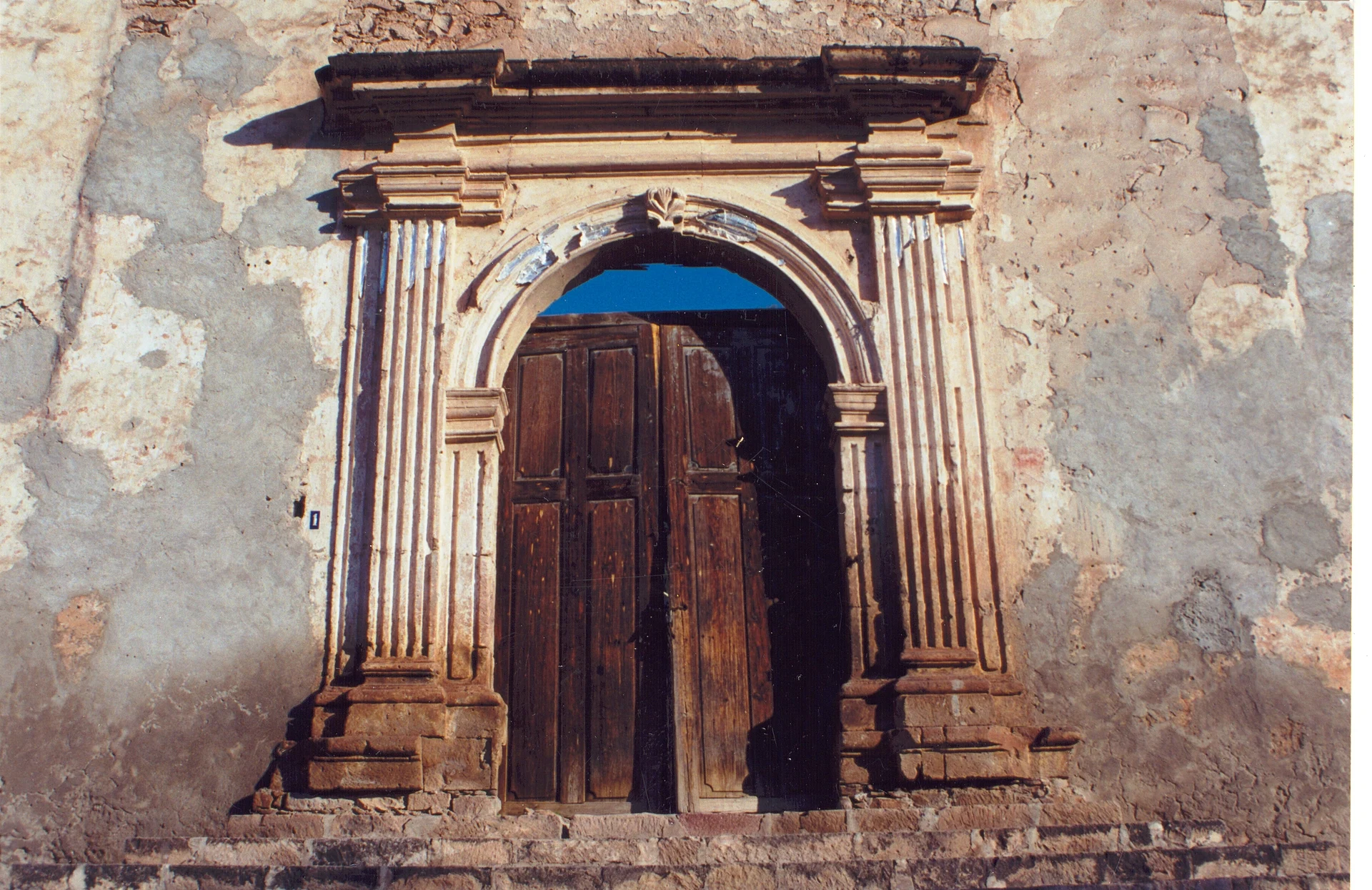
Village Bolaños, Jalisco
Former silver-mining town in the Bolaños river canyon in northern Jalisco, with ruined mansions, the Parroquia Vieja and Wixárika crafts.
From Tepic: about 2 h 20 min by road (~155 km) How to get there ↓
Near here
See everything nearby ↓


Plan your visit to Bolaños
Where to stay near Bolaños
Compare hotels, posadas and guest houses in Bolaños.
Tours to Bolaños
Day trips and guided outings from Teúl de González Ortega often include Bolaños; with a local guide you can get there without a car.
How to get to Bolaños
- From Tepic: about 2 h 20 min by road (~155 km)
- Nearest airport: Guadalajara (GDL), 2 h 22 min by car to Teúl de González Ortega
Links open a partner site. We may earn a commission if you book, at no cost to you.
About Bolaños
Bolaños is the seat of the municipality of the same name in northern Jalisco, at about 893 metres above sea level and roughly 300 km from Guadalajara. The 2020 census counted 1,086 people, a long way from the 17,000 that some accounts give for its mining peak. Its old full name was Villa del Real de Bolaños, after Toribio de Bolaños, an early encomendero and mine owner in the region.
The area was conquered in 1530 by Pedro Almíndez Chirinos, sent by Nuño de Guzmán, and was then home to Tepecano and Wixárika (Huichol) people. The boom came in 1748, when José Barranco opened the mine that bore his name; between 1740 and 1780 the district ranked among the three most important in the economy of New Spain, credited with about 20% of its silver. Output dropped sharply around 1830. The town was given the title of mining city in 1833, became a department seat in 1846, and was made a municipality on 18 September 1875.
What remains of that wealth is a scatter of decaying mansions and 18th- and 19th-century buildings: the Real Caja, the Casas Consistoriales, the Parroquia Vieja, the Santuario de Guadalupe and the church of La Playa. Around the town lies the Bolaños canyon, with its river along the bottom and near-vertical walls, plus sights such as the English dam and aqueduct and several old mines. The town is also a crossing point for Wixárika culture: beadwork, embroidered bags, yarn "eyes of God" and yarn paintings are sold here. The climate is semi-warm, with about 629 mm of rain a year, almost all between June and September, and mean temperatures reaching 29 °C in May and June.
How to get to Bolaños
Bolaños lies in northern Jalisco, about 300 km from Guadalajara, and borders the municipalities of Villa Guerrero, Chimaltitán, Mezquitic and San Martín de Bolaños. The municipality has low road connectivity, so plan for a long trip through mountain country. By bus, route planners list a Rojo de los Altos service from Guadalajara's Nueva Central Camionera (sala 2), one departure a day and about 7 hours on the road; schedules change, so confirm at the terminal. Another listed combination is a bus to Atolinga and then a taxi of a little over an hour to Bolaños. By car, check the route and road conditions before setting out.
Directions to Bolaños on Google Maps
Distances are in a straight line; the road is usually longer.
Links open a partner site. We may earn a commission if you book, at no cost to you.
From the nearest cities to Bolaños
- Tepic · about 155 km by road, ~2 h 20 min
- San Juan de los Lagos · about 210 km by road, ~3 h 5 min
- Guadalajara · 221 km by road, 4 h 10 min
Drive times by road from OpenStreetMap, without traffic or stops. Times marked ~ are estimated from the straight-line distance.
Before you go to Bolaños: hours, prices and tips
- Best season
- Spring fair 26 April–10 May; patron saint San José Obrero 23 April–1 May; Virgin of Guadalupe 4–12 December; Day of the Dead 2 November. Wikipedia: Municipio de Bolaños · checked Oct 2026
Hours and prices change, especially around holidays. Each fact links to where we checked it.
Visiting Bolaños: what to see and do
Walk among the decaying mansions and buildings of the old mining town.
Visit the Parroquia Vieja and its carved stone doorway.
Look for the Real Caja and the Casas Consistoriales, 18th-century buildings.
Look out over the Bolaños canyon and the river along its floor.
Buy Wixárika crafts: beadwork, embroidered bags and yarn paintings.
Plan your trip
Places to stay in Bolaños
Compare hotels, posadas, and rentals in and around Bolaños.
Tours & activities
Day trips and guided outings from Teúl de González Ortega often include Bolaños; with a local guide you can get there without a car.
Rental cars
Pick up a car at GDL (Guadalajara): about 2 h 22 min by road to Teúl de González Ortega, then 53 km more to Bolaños, on your own schedule.
Flights
The nearest airport with scheduled flights is Guadalajara (GDL), about 2 h 22 min by road from Teúl de González Ortega, the base for Bolaños.
Mobile data
Signal can drop away from Teúl de González Ortega: download a map of the way to Bolaños before you set out, or carry an eSIM with data.
Links open a partner site. We may earn a commission if you book, at no cost to you.
When to go to Bolaños mild
Bolaños shares the climate of Teúl de González Ortega, 53 km away. The best months to visit are March, April, May, and November.
See the month-by-month climate of Teúl de González Ortega
Weather in Bolaños now and the next 7 days
Live forecast from Open-Meteo. Chance of rain is the day's highest.
The closest Pueblo Mágico: Teúl de González Ortega

Teúl de González Ortega is the Pueblo Mágico closest to Bolaños, with places to stay, food, and more to see.
Closest to Bolaños
-
Chimaltitán · Village · 6 km away
-
San Martín de Bolaños · Town · 17 km away
-
Tuxpan de Bolaños · Village · 24 km away
-
Temastián · Village · 31 km away
-
Totatiche · Village · 36 km away
Near Bolaños




Drive times by road from OpenStreetMap, without traffic. Times marked ~ are estimated from the straight-line distance.
Location from OpenStreetMap. Written by Puebloteca.