
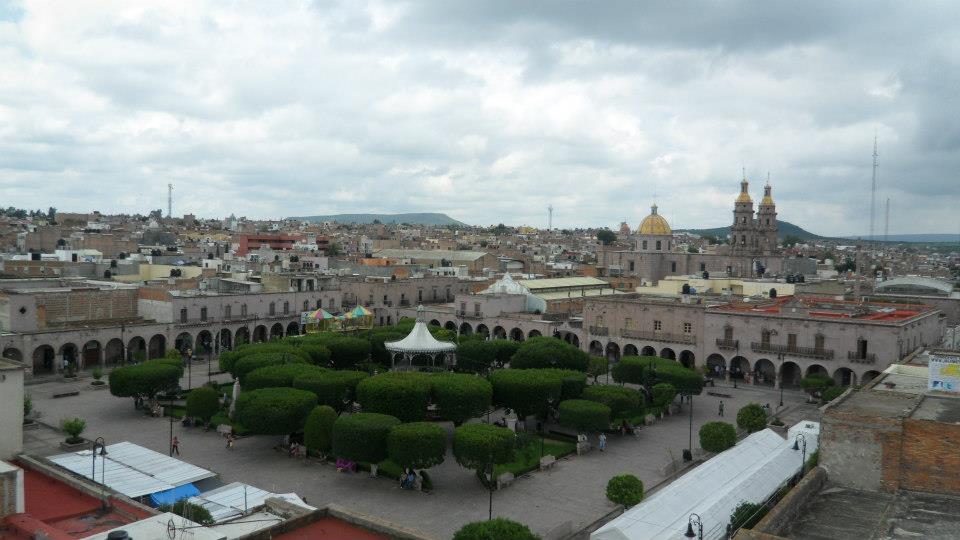
Town San Miguel el Alto, Jalisco
A pink-stone Altos de Jalisco town, an INAH historic monuments zone since 2001, 35 minutes from San Juan de los Lagos.
From San Juan de los Lagos: about 30 min by road (~35 km) How to get there ↓
Near here
See everything nearby ↓


Plan your visit to San Miguel el Alto
Where to stay near San Miguel el Alto
Compare hotels, posadas and guest houses in San Miguel el Alto.
Tours to San Miguel el Alto
Day trips around Temacapulín sometimes stop in San Miguel el Alto; a tour is the easy way to see it without a car.
How to get to San Miguel el Alto
- From San Juan de los Lagos: about 30 min by road (~35 km)
- Nearest airport: Aguascalientes (AGU), 2 h 1 min by car to Temacapulín
Links open a partner site. We may earn a commission if you book, at no cost to you.
About San Miguel el Alto
San Miguel el Alto is the seat of the municipality of the same name in the Altos Sur region of Jalisco, at 1,851 metres. The 2020 census counted 25,925 people. The town lives off textile workshops, cattle and the pink cantera stone quarried nearby, which is also what much of its centre is built from.
Before the Spanish arrived it was Atonayalco, "across the river", under the Tecuexe lordship. Cristóbal de Oñate took the area in 1530, and families from Nochistlán resettled it in the mid-16th century. It was first San Miguel del Ojo de Agua, then San Miguel de los Alcalanes, after a Spanish family named Alcalá who settled east of Friar Miguel de Bolonia's chapel in 1571. A column in the church atrium marks the spot where, by the town's own history, the Franciscans laid it out in 1625.
It became a villa in 1880 and a city in 1970, and lived through royalist reprisals in 1813 and the Cristero War of the 1920s. In March 2001 INAH declared its centre a Zone of Historic Monuments for its churches and stone houses. The patron saint is Michael the Archangel. The climate is mild, averaging 17.6 °C, with summer rain.
How to get to San Miguel el Alto
San Miguel el Alto sits in the Altos de Jalisco, between Tepatitlán and San Juan de los Lagos. From San Juan de los Lagos it is about 35 minutes by car (37 km by road). The nearest Pueblo Mágico, Temacapulín, is 1 h 5 min away (48 km). From Guadalajara, take the highway towards Tepatitlán and the Altos, then on to San Miguel el Alto.
Directions to San Miguel el Alto on Google Maps
Distances are in a straight line; the road is usually longer.
Links open a partner site. We may earn a commission if you book, at no cost to you.
From the nearest cities to San Miguel el Alto
- San Juan de los Lagos · about 35 km by road, ~30 min
- Arandas · about 45 km by road, ~40 min
- Tepatitlán · about 55 km by road, ~50 min
Drive times by road from OpenStreetMap, without traffic or stops. Times marked ~ are estimated from the straight-line distance.
Visiting San Miguel el Alto: what to see and do
Walk the historic monuments zone in the centre, with its pink cantera facades.
Find the column in the parish atrium that marks the Franciscan founding.
Visit the parish church of Saint Michael the Archangel, the town's patron.
Shop for clothes and textiles from the local workshops.
Plan your trip
Places to stay in San Miguel el Alto
Compare hotels, posadas, and rentals in and around San Miguel el Alto.
Tours & activities
Day trips around Temacapulín sometimes stop in San Miguel el Alto; a tour is the easy way to see it without a car.
Rental cars
Pick up a car at AGU (Aguascalientes): about 2 h 1 min by road to Temacapulín, then 36 km more to San Miguel el Alto, on your own schedule.
Flights
The nearest airport with scheduled flights is Aguascalientes (AGU), about 2 h 1 min by road from Temacapulín, the base for San Miguel el Alto.
Mobile data
Signal can drop away from Temacapulín: download a map of the way to San Miguel el Alto before you set out, or carry an eSIM with data.
Links open a partner site. We may earn a commission if you book, at no cost to you.
When to go to San Miguel el Alto mild
San Miguel el Alto shares the climate of Temacapulín, 36 km away. The best months to visit are January, March, April, and November.
See the month-by-month climate of Temacapulín
Weather in San Miguel el Alto now and the next 7 days
Live forecast from Open-Meteo. Chance of rain is the day's highest.
The closest Pueblo Mágico: Temacapulín

Temacapulín is the Pueblo Mágico closest to San Miguel el Alto, with places to stay, food, and more to see.
Also close to
- Jalpa de Cánovas · Guanajuato · 47 km away
- Nochistlán · Zacatecas · 59 km away
- Lagos de Moreno · Jalisco · 62 km away
Closest to San Miguel el Alto
-
Jalostotitlán · Town · 17 km away
-
Mirandillas · Village · 17 km away
-
Valle de Guadalupe · Village · 22 km away
-
San Juan de los Lagos · Town · 25 km away
-
Pegueros · Village · 29 km away
-
Capilla de Guadalupe · Town · 30 km away
-
Cañadas de Obregón · Town · 32 km away
-
San Ignacio Cerro Gordo · Town · 35 km away


Near San Miguel el Alto



Drive times by road from OpenStreetMap, without traffic. Times marked ~ are estimated from the straight-line distance.
Location from OpenStreetMap. Written by Puebloteca.