
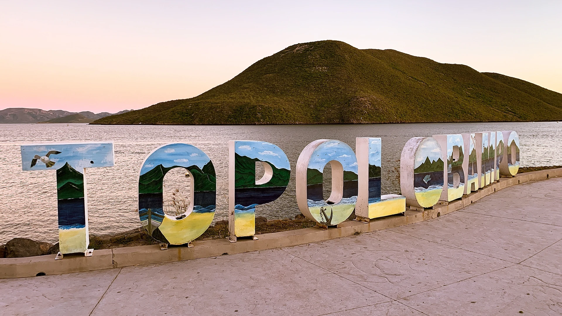
Town Ahome, Sinaloa Municipality of Ahome Northern Sinaloa
Ahome's port on the Gulf of California: the ferry to La Paz, boat trips to see the dolphin Pechocho and bird islands, and a 19th-century utopian colony.
From Los Mochis: 25 min by car (24 km by road) How to get there ↓
Near here
See everything nearby ↓


Plan your visit to Topolobampo
Where to stay near Topolobampo
Compare hotels, posadas and guest houses in Topolobampo.
Tours to Topolobampo
Day trips around El Fuerte sometimes stop in Topolobampo; a tour is the easy way to see it without a car.
How to get to Topolobampo
- From Los Mochis: about 25 min by road (~24 km)
- Nearest airport: Los Mochis (LMM), 1 h 37 min by car to El Fuerte
Links open a partner site. We may earn a commission if you book, at no cost to you.
About Topolobampo
Topolobampo is the port of Ahome municipality, set on a sheltered bay of the Gulf of California a little over 20 km from Los Mochis. Only 6,198 people lived here in 2020, but the town matters far beyond its size. Ferries leave from here for La Paz in Baja California Sur; it is the starting point of the La Entrada al Pacífico trade corridor that runs to Midland and Odessa, Texas; and its docks handle oil, cars and other cargo. The old railway station still stands by the port, with a steel plate on its canopy naming the line's original route, Ojinaga to Topolobampo; local families live in it now. The Chihuahua al Pacífico railway itself was only completed in 1962, and its passenger terminal is in Los Mochis.
The town has a strange past. From 1884 to 1894 it hosted a colony of American utopian socialists led by the engineer Albert Kimsey Owen and inspired by Henry George's economics, with Marie Howland and John W. Lovell among its backers. They printed an English-language paper, The Credit Foncier of Sinaloa. Porfirio Díaz's government supported the project, yet every venture failed; the settlers ran short of food and clean water, and in 1888 the US Navy sent the USS Iroquois to take them home, an offer nobody accepted. The historian José C. Valadés called it the socialist metropolis of the West. In 1914, during the Revolution, a Constitutionalist plane attacked federal warships off this coast, an engagement often called the first air-naval battle in history, and the state congress later declared Topolobampo a Heroic Port.
Visitors spend their time on the waterfront and the Pablo Neruda promenade, with lookouts, prepared coconuts, snacks and crafts. From there the Las Hamacas tourism cooperative runs boats every day from 9 am to 7 pm. The favorite trip is to see Pechocho, a lone dolphin that has lived in the bay for more than 30 years and often swims up to the boats on its own. Other routes go to the Bird Sanctuary, a cactus-covered island; to Las Hamacas, Las Copas, Santa María and El Maviri beaches; to the Casita del Ostión, a floating seafood restaurant; to Farallón island and its sea lions; or out sport fishing, also offered by the port's yacht clubs and marinas. The bat cave at El Maviri is about 8 km away, and foreign cruise ships call in the bay. The local specialty is pescado zarandeado, fish butterflied and grilled over coals.
The Baja Ferries boat to La Paz leaves Monday to Friday around midnight and reaches La Paz at about 9 am; it carries passengers and vehicles and has cabins for an extra charge. The climate is hot and dry, with the hottest months from May to October and most rain from July to September.
How to get to Topolobampo
Drive from Los Mochis: 25 min, 24 km
From Los Mochis, take the Los Mochis–Topolobampo road about 20 km south; a taxi takes around 30 minutes. In Los Mochis each bus company has its own terminal, and regional transport runs to the port. Los Mochis airport has domestic flights. The nearest Pueblo Mágico is El Fuerte, an hour and twenty minutes from Los Mochis on the Los Mochis–El Fuerte road; Baja Ferries also arrive here from La Paz.
Directions to Topolobampo on Google Maps
Distances are in a straight line; the road is usually longer.
Links open a partner site. We may earn a commission if you book, at no cost to you.
From the nearest cities to Topolobampo
- Los Mochis · 24 km by road, 25 min
- Guasave · 83 km by road, 1 h 10 min
- Guamúchil · 126 km by road, 1 h 45 min
Drive times by road from OpenStreetMap, without traffic or stops. Times marked ~ are estimated from the straight-line distance.
Before you go to Topolobampo: hours, prices and tips
- Hours
- Las Hamacas cooperative boats: daily 9 am to 7 pm from the waterfront (2025). Luz Noticias · checked Oct 2026
- Entry
- Bay tour 800 pesos per boat (45 min to 1 h); Pechocho 1,600; Bird Sanctuary 1,300; full package 2,900 (2025). Luz Noticias · checked Oct 2026
- Guide or tour
- Bay and island trips are made by boat with the Las Hamacas tourism cooperative. Tours: Viator GetYourGuide Luz Noticias · checked Oct 2026
- Rules
- Swimming is not allowed in the area where Pechocho the dolphin lives. México Desconocido · checked Oct 2026
Hours and prices change, especially around holidays. Each fact links to where we checked it.
Visiting Topolobampo: what to see and do
The waterfront and the Pablo Neruda promenade, with lookouts and snacks.
A boat trip to meet Pechocho the dolphin.
The Bird Sanctuary, a cactus island in the bay.
Farallón island and its sea lions.
A meal at the Casita del Ostión, a floating restaurant.
The old station with its Ojinaga–Topolobampo plate.
The overnight ferry to La Paz, Baja California Sur.
Plan your trip
Places to stay in Topolobampo
Compare hotels, posadas, and rentals in and around Topolobampo.
Tours & activities
Day trips around El Fuerte sometimes stop in Topolobampo; a tour is the easy way to see it without a car.
Rental cars
Pick up a car at LMM (Los Mochis): about 1 h 37 min by road to El Fuerte, then 99 km more to Topolobampo, on your own schedule.
Flights
The nearest airport with scheduled flights is Los Mochis (LMM), about 1 h 37 min by road from El Fuerte, the base for Topolobampo.
Mobile data
Signal can drop away from El Fuerte: download a map of the way to Topolobampo before you set out, or carry an eSIM with data.
Links open a partner site. We may earn a commission if you book, at no cost to you.
When to go to Topolobampo warm
Topolobampo shares the climate of El Fuerte, 99 km away. The best months to visit are January, March, November, and December.
See the month-by-month climate of El Fuerte
Weather in Topolobampo now and the next 7 days
Live forecast from Open-Meteo. Chance of rain is the day's highest.
The closest Pueblo Mágico: El Fuerte

El Fuerte is the Pueblo Mágico closest to Topolobampo, with places to stay, food, and more to see.
Closest to Topolobampo
-
El Maviri · Beach · 7 km away
-
Ahome · Town · 37 km away
-
Mochicahui · Town · 41 km away
Near Topolobampo



Drive times by road from OpenStreetMap, without traffic. Times marked ~ are estimated from the straight-line distance.
Location from OpenStreetMap. Written by Puebloteca.