
Town Tlalnepantla de Baz, Estado de México Municipality of Tlalnepantla de Baz Valley of Mexico
San Juanico, east Tlalnepantla: a church finished in 1616, a wax-mask carnival and the memory of the 1984 Pemex gas explosion.
From Mexico City: 20 min by car (13 km by road) How to get there ↓
Near here


Plan your visit to San Juan Ixhuatepec
Where to stay near San Juan Ixhuatepec
Compare hotels, posadas and guest houses in San Juan Ixhuatepec.
Tours to San Juan Ixhuatepec
Day trips around Tepotzotlán sometimes stop in San Juan Ixhuatepec; a tour is the easy way to see it without a car.
 Tours from Mexico City
Teotihuacan pyramids morning or afternoon without tourist traps
★ 4.9 (10,269) · From US$59
How to get to San Juan Ixhuatepec
- From Mexico City: about 20 min by road (~13 km)
- Nearest airport: Mexico City (Felipe Ángeles) (NLU), 48 min by car to Tepotzotlán
Links open a partner site. We may earn a commission if you book, at no cost to you.
Tours from Mexico City, near San Juan Ixhuatepec


Tours, prices and ratings from Viator, checked weekly. We may earn a commission if you book.
About San Juan Ixhuatepec
San Juan Ixhuatepec, which everyone calls San Juanico, is one of the "islands" of the State of Mexico: an exclave of Tlalnepantla de Baz cut off from its municipal seat since the 19th century by Mexico City's Gustavo A. Madero borough. It lies at the foot of the Sierra de Guadalupe beside the Pachuca highway and serves as the administrative centre of the municipality's eastern zone. The Nahuatl name reads roughly "hill of leaves".
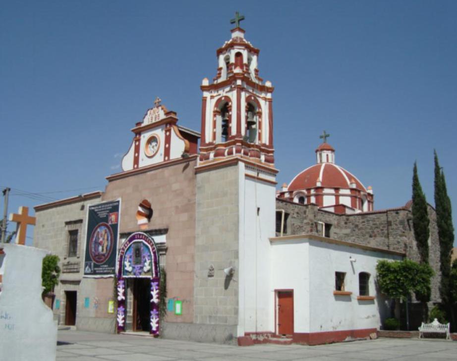
The village's story is in its parish of San Juan Bautista. In 1539 the local lords agreed to raise a thatched hermitage; around 1599 it was pulled down, and in 1603 work began on a masonry chapel paid for by neighbours and finished in 1616 in white cantera stone. It was refaced in 1925 with pink and grey stone and given a clock donated by the landowner Hermilo Mena.
Its own festival is the carnival, three days before Ash Wednesday. It is the only pueblo in Tlalnepantla that holds one, and it keeps the "ahorcado" (the hanged man), the "locos" in wax masks and the "consentidas", men dressed as women; the masks are made in the village itself. The patron feast is 24 June.
The place is also known for 19 November 1984. At about 5:45 a.m. a pipe burst at a Pemex liquefied petroleum gas terminal and explosions went on for hours. The official toll was 503 dead, with estimates of 500 to 600, and 5,000 to 7,000 injured, mostly residents. A park was built south of the site where the destroyed houses had stood. Today it is a dense district of neighbourhoods, markets and workshops, with 16 colonias and 3 housing complexes around the old village.
How to get to San Juan Ixhuatepec
Drive from Mexico City: 20 min, 13 km
By car: from central Mexico City take Avenida Insurgentes Norte, which becomes the Mexico–Pachuca road (85), or the 85D toll highway; San Juan Ixhuatepec lies on the west side of that road, between the Periférico (Río de los Remedios) and Avenida Centenario. It is about 10 km in a straight line from the centre, roughly 25 to 40 minutes depending on traffic.
By public transport: Mexicable Line 2 (Indios Verdes to Hank González, opened 30 March 2023) has stations such as Tanque de Agua, Periférico and San Isidro a couple of kilometres from the village, and Metro Line 3 is at Indios Verdes. Mexibús Line 4 stops at Martín Carrera. Combis and taxis cover the last stretch. The nearest pueblo, Tepotzotlán, is about 25 km as the crow flies, roughly 40 minutes.
Directions to San Juan Ixhuatepec on Google Maps
Distances are in a straight line; the road is usually longer.
Links open a partner site. We may earn a commission if you book, at no cost to you.
From the nearest cities to San Juan Ixhuatepec
- Mexico City · 13 km by road, 20 min
- Pachuca · 82 km by road, 1 h 5 min
- Toluca · 79 km by road, 1 h 15 min
Drive times by road from OpenStreetMap, without traffic or stops. Times marked ~ are estimated from the straight-line distance.
What to see in San Juan Ixhuatepec 4
Sights with their own page, closest to the centre first.
Mountains
-
Cerro Zacatenco · Mountain · 1 km from the centre
The biggest hill in the city's far north, in the Sierra de Guadalupe: Preclassic villages on its slopes, antennas on top and the best view from the Cablebús. -
Cerro del Chiquihuite · Mountain · 3 km from the centre
A 2,730 m volcanic dome in the Sierra de Guadalupe, topped by antennas and ringed by homes; Templo Mayor stone came from here. Cablebús Line 1 serves it. -
Cerro del Tepeyac · Mountain · 4 km from the centre
The hill above the Basilica: 18th-century stairways, the Capilla del Cerrito with Fernando Leal's murals, a historic cemetery and a view of the valley.
Landmarks and museums
-
Basílica de Guadalupe · Landmark · 4 km from the centre
Mexico's great Marian shrine at the foot of Tepeyac: the round 1976 basilica with Juan Diego's tilma, the tilting 1709 church and hilltop chapels.
Map of San Juan Ixhuatepec
Day trips and tours from San Juan Ixhuatepec
The closest Pueblos Mágicos and places to visit, with the drive from San Juan Ixhuatepec and tours that leave from it.


Times marked ~ are estimated from the distance. Links open a partner site. We may earn a commission if you book, at no cost to you.
Before you go: getting to and around San Juan Ixhuatepec
- The nearest airport is Mexico City (Felipe Ángeles) (NLU).
- The best months to go are January, February, March, and December.
- 2 of the places on this page are more than 3 km from the centre: take a taxi, a ride-hailing app or a local bus.
- For day trips a rental car gives the most freedom; the tours above leave from San Juan Ixhuatepec.
Before you go to San Juan Ixhuatepec: hours, prices and tips
- Best time of day
- Carnival, three days before Ash Wednesday, is the local festival; the patron feast of San Juan Bautista is on 24 June. Wikipedia (es): San Juan Ixhuatepec · checked Oct 2026
Hours and prices change, especially around holidays. Each fact links to where we checked it.
Visiting San Juan Ixhuatepec: what to see and do
The parish of San Juan Bautista: chapel finished in 1616 and refaced in 1925, with a clock on the façade.
The carnival before Ash Wednesday, with the hanged man, the wax-masked locos and the consentidas.
The feast of San Juan Bautista on 24 June.
The park south of the 1984 explosion site, where the destroyed houses stood.
The hills of the Sierra de Guadalupe around the village.
Plan your trip
Places to stay in San Juan Ixhuatepec
Compare hotels, posadas, and rentals in and around San Juan Ixhuatepec.
Tours & activities
Day trips around Tepotzotlán sometimes stop in San Juan Ixhuatepec; a tour is the easy way to see it without a car.
Rental cars
Pick up a car at NLU (Mexico City (Felipe Ángeles)): about 48 min by road to Tepotzotlán, then 25 km more to San Juan Ixhuatepec, on your own schedule.
Flights
The nearest airport with scheduled flights is Mexico City (Felipe Ángeles) (NLU), about 48 min by road from Tepotzotlán, the base for San Juan Ixhuatepec.
Mobile data
Signal can drop away from Tepotzotlán: download a map of the way to San Juan Ixhuatepec before you set out, or carry an eSIM with data.
Links open a partner site. We may earn a commission if you book, at no cost to you.
When to go to San Juan Ixhuatepec cool
San Juan Ixhuatepec shares the climate of Tepotzotlán, 25 km away. The best months to visit are January, February, March, and December.
See the month-by-month climate of Tepotzotlán
Weather in San Juan Ixhuatepec now and the next 7 days
Live forecast from Open-Meteo. Chance of rain is the day's highest.
The closest Pueblo Mágico: Tepotzotlán

Tepotzotlán is the Pueblo Mágico closest to San Juan Ixhuatepec, with places to stay, food, and more to see.
Also close to
- Teotihuacán · Estado de México · 33 km away
- Otumba · Estado de México · 42 km away
- Villa del Carbón · Estado de México · 44 km away
- Tepoztlán · Morelos · 60 km away
- Metepec · Estado de México · 60 km away
Near San Juan Ixhuatepec


Drive times by road from OpenStreetMap, without traffic. Times marked ~ are estimated from the straight-line distance.
Location from OpenStreetMap. Written by Puebloteca.