City Tlalnepantla de Baz, Estado de México Municipality of Tlalnepantla de Baz Valley of Mexico
An industrial city on Mexico City's northern edge with the Corpus Christi cathedral, municipal murals, two haciendas and the Tren Suburbano at hand.
From Mexico City: 25 min by car (16 km by road) How to get there ↓
Near here


Plan your visit to Tlalnepantla
Where to stay near Tlalnepantla
Compare hotels, posadas and guest houses in Tlalnepantla.
Tours to Tlalnepantla
Day trips and guided outings from Tepotzotlán often include Tlalnepantla; with a local guide you can get there without a car.
 Tours from Mexico City
Teotihuacan pyramids morning or afternoon without tourist traps
★ 4.9 (10,269) · From US$59
How to get to Tlalnepantla
- From Mexico City: about 25 min by road (~16 km)
- Nearest airport: Mexico City (Felipe Ángeles) (NLU), 48 min by car to Tepotzotlán
Links open a partner site. We may earn a commission if you book, at no cost to you.
Tours from Mexico City, near Tlalnepantla


Tours, prices and ratings from Viator, checked weekly. We may earn a commission if you book.
About Tlalnepantla
Tlalnepantla, officially Tlalnepantla de Baz, is the seat of the municipality of the same name and counted 658,907 people in the 2020 INEGI census. It lies about 10 km north of Mexico City's Centro Histórico, and although the Nahuatl name means "in the middle of the land", the city is split into two parts by the capital itself. The "Baz" honours the physician and revolutionary Gustavo Baz Prada. The area was Chichimec, with Tenayuca as its centre, became a Franciscan town from 1550, and in the 20th century filled with factories and workers. Today it is a working city rather than a tourist one, and is best visited with that in mind.
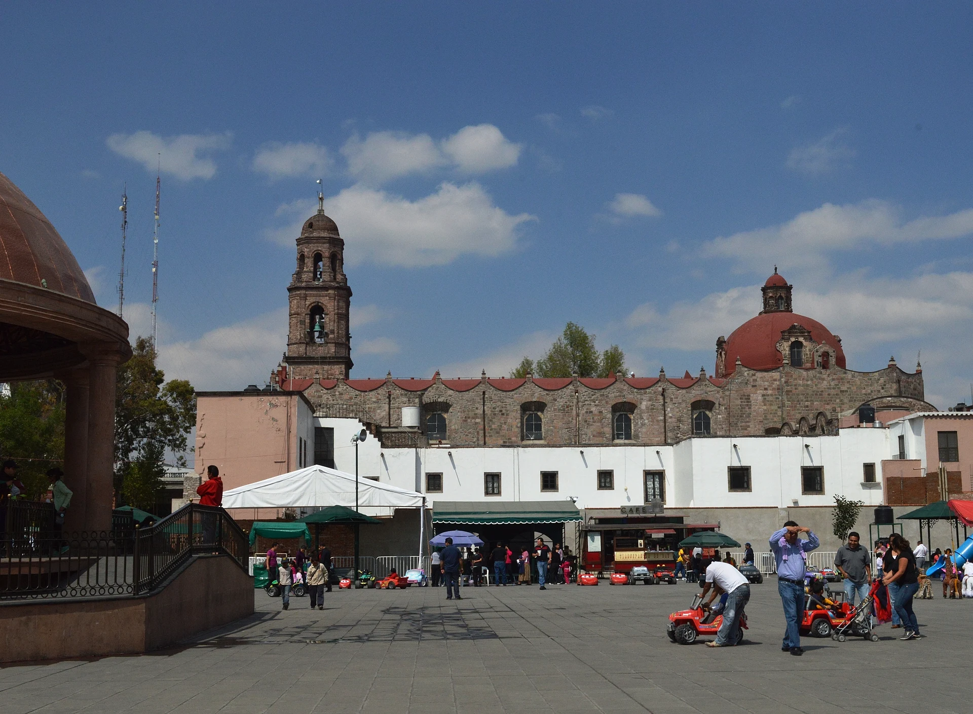
On the main plaza, the Franciscan convent of Corpus Christi was built between 1525 and 1587 according to local historians; it carries Otomi and Mexica inscriptions on its outer walls and a gilded Baroque altarpiece. Next to the cathedral the Palacio Municipal is covered in murals: those of 1955-56, a 1994 painting by Julio Carrasco Bretón and a 1996 work by UNAM's Grupo de Artes Plásticas.
On the outskirts two haciendas survive. Santa Mónica, bought by the Augustinians in 1573, works as a house museum with rooms of tapestries, clocks and furniture from past centuries, and opens only on Sundays. The Ex-Hacienda de Enmedio, built of stone in Porfirian times, is a frequent set for soap operas and weddings. The municipality also holds the Mexica pyramids of Tenayuca and Santa Cecilia Acatitlán, which have their own pages, and the Sierra de Guadalupe state park to the north.
How to get to Tlalnepantla
Drive from Mexico City: 25 min, 16 km
The most practical route from Mexico City is the Tren Suburbano: take the Metro or Metrobús to Buenavista, buy the train's own farecard in the terminal (Metro cards are not valid), board toward Cuautitlán and get off at Tlalnepantla station on Av. Chilpancingo, a bit over a kilometre from the cathedral, where local buses connect. By car, the Periférico Norte and the Mexico-Querétaro highway cross the city; it is about 10 km from central Mexico City, though evening rush hour (roughly 5 to 8 pm) stretches it a lot. From Tepotzotlán it is about 20 km in a straight line; by road allow over half an hour, depending on traffic. Inside the city, ride-hailing with Uber or Didi is the easier way to get around.
Directions to Tlalnepantla on Google Maps
Distances are in a straight line; the road is usually longer.
Links open a partner site. We may earn a commission if you book, at no cost to you.
From the nearest cities to Tlalnepantla
- Mexico City · 16 km by road, 25 min
- Toluca · 69 km by road, 1 h 5 min
- Pachuca · 94 km by road, 1 h 15 min
Drive times by road from OpenStreetMap, without traffic or stops. Times marked ~ are estimated from the straight-line distance.
What to see in Tlalnepantla 3
Sights with their own page, closest to the centre first.
Archaeological sites
-
Pirámide de Tenayuca · Archaeological site · 3 km from the centre
A Chichimec and Aztec pyramid rebuilt over itself many times, ringed by a wall of 138 carved stone serpents. -
Santa Cecilia Acatitlan · Archaeological site · 3 km from the centre
A small Mexica pyramid with its temple rebuilt on top, the best idea of how Aztec shrines looked, plus a little museum.
Landmarks and museums
-
Tenayuca-Santa Cecilia · Landmark · 3 km from the centre
Two old villages in Tlalnepantla with Chichimec and Aztec pyramids, a 16th-century parish and barrio fiestas. A Barrio Mágico since 2024.
Map of Tlalnepantla
Neighbourhoods and villages of Tlalnepantla
Part of Tlalnepantla or just outside it, closest first.
-
San Juan Ixhuatepec · Town · 9 km from the centre
San Juanico, east Tlalnepantla: a church finished in 1616, a wax-mask carnival and the memory of the 1984 Pemex gas explosion.

Day trips and tours from Tlalnepantla
The closest Pueblos Mágicos and places to visit, with the drive from Tlalnepantla and tours that leave from it.


Times marked ~ are estimated from the distance. Links open a partner site. We may earn a commission if you book, at no cost to you.
Before you go: getting to and around Tlalnepantla
- The nearest airport is Mexico City (Felipe Ángeles) (NLU).
- The best months to go are January, February, March, and December.
- 1 of the places on this page is more than 3 km from the centre: take a taxi, a ride-hailing app or a local bus.
- For day trips a rental car gives the most freedom; the tours above leave from Tlalnepantla.
Before you go to Tlalnepantla: hours, prices and tips
- Hours
- The Hacienda de Santa Mónica house museum opens only on Sundays, 11 am to 5 pm. The Ex-Hacienda de Enmedio is open Tuesday to Sunday, 9 am to 6 pm. Wikivoyage · checked Oct 2026
- Rules
- Tlalnepantla is mostly industrial and residential; sights are generally safe by day, but avoid straying into unfamiliar neighbourhoods and prefer Uber or Didi to street taxis and peseros. Wikivoyage · checked Oct 2026
Hours and prices change, especially around holidays. Each fact links to where we checked it.
Visiting Tlalnepantla: what to see and do
The Corpus Christi convent and cathedral, with Otomi and Mexica inscriptions on its walls.
The murals in the Palacio Municipal on the plaza.
The Hacienda de Santa Mónica house museum (Sundays only).
The stone Ex-Hacienda de Enmedio, with gardens and guided visits.
The pyramids of Tenayuca and their INAH site museum.
The Santa Cecilia Acatitlán archaeological zone, with a rebuilt pyramid and museum.
The Sierra de Guadalupe state park on the north side of the municipality.
Plan your trip
Places to stay in Tlalnepantla
Compare hotels, posadas, and rentals in and around Tlalnepantla.
Tours & activities
Day trips and guided outings from Tepotzotlán often include Tlalnepantla; with a local guide you can get there without a car.
Rental cars
Pick up a car at NLU (Mexico City (Felipe Ángeles)): about 48 min by road to Tepotzotlán, then 20 km more to Tlalnepantla, on your own schedule.
Flights
The nearest airport with scheduled flights is Mexico City (Felipe Ángeles) (NLU), about 48 min by road from Tepotzotlán, the base for Tlalnepantla.
Mobile data
Signal can drop away from Tepotzotlán: download a map of the way to Tlalnepantla before you set out, or carry an eSIM with data.
Links open a partner site. We may earn a commission if you book, at no cost to you.
When to go to Tlalnepantla cool
Tlalnepantla shares the climate of Tepotzotlán, 20 km away. The best months to visit are January, February, March, and December.
See the month-by-month climate of Tepotzotlán
Weather in Tlalnepantla now and the next 7 days
Live forecast from Open-Meteo. Chance of rain is the day's highest.
The closest Pueblo Mágico: Tepotzotlán

Tepotzotlán is the Pueblo Mágico closest to Tlalnepantla, with places to stay, food, and more to see.
Also close to
- Villa del Carbón · Estado de México · 35 km away
- Teotihuacán · Estado de México · 41 km away
- Otumba · Estado de México · 49 km away
- Metepec · Estado de México · 53 km away
- Jilotepec · Estado de México · 58 km away
Near Tlalnepantla


Drive times by road from OpenStreetMap, without traffic. Times marked ~ are estimated from the straight-line distance.
Location from OpenStreetMap. Written by Puebloteca.