
Mountain Gustavo A. Madero, Ciudad de México Municipality of Gustavo A. Madero Valley of Mexico
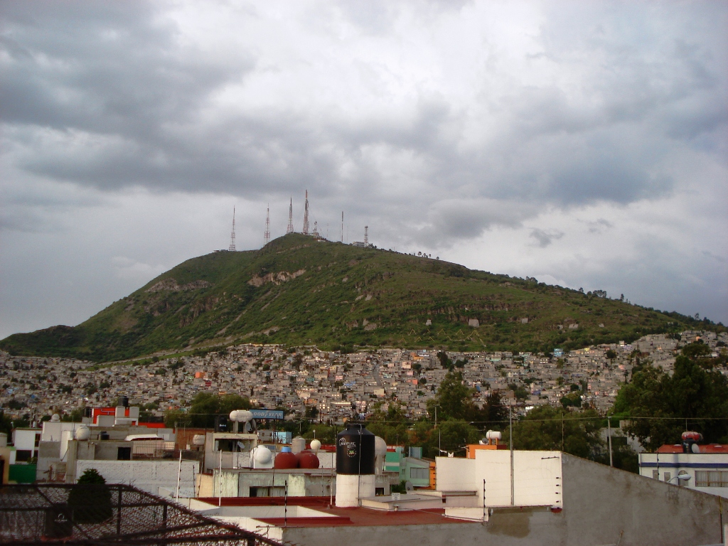
A 2,730 m volcanic dome in the Sierra de Guadalupe, topped by antennas and ringed by homes; Templo Mayor stone came from here. Cablebús Line 1 serves it.
From Mexico City: 35 min by car (20 km by road) How to get there ↓
Near here
See everything nearby ↓


Plan your visit to Cerro del Chiquihuite
Where to stay near Cerro del Chiquihuite
Compare hotels, posadas and guest houses in Cerro del Chiquihuite.
Tours to Cerro del Chiquihuite
Day trips and guided outings from Tepotzotlán often include Cerro del Chiquihuite; with a local guide you can get there without a car.
 Tours from Mexico City
Teotihuacan pyramids morning or afternoon without tourist traps
★ 4.9 (10,269) · From US$59
How to get to Cerro del Chiquihuite
- From Mexico City: about 35 min by road (~20 km)
- Nearest airport: Mexico City (Felipe Ángeles) (NLU), 48 min by car to Tepotzotlán
Links open a partner site. We may earn a commission if you book, at no cost to you.
Tours from Mexico City, near Cerro del Chiquihuite


Tours, prices and ratings from Viator, checked weekly. We may earn a commission if you book.
About Cerro del Chiquihuite
Cerro del Chiquihuite is a 2,730 m volcanic dome in the Sierra de Guadalupe, in the north of the Valley of Mexico. It is split between the Gustavo A. Madero borough on the west and the State of Mexico municipality of Tlalnepantla de Baz on the east. It is not a hiking hill with marked trails: its lower slopes are covered in working-class neighbourhoods, among them Tlalpexco, Cuautepec, La Pastora and Ticomán on the capital's side and Lázaro Cárdenas (La Presa) on the Tlalnepantla side, and the summit carries an antenna farm for several TV and radio stations, served by a road.
The rock is a pink-to-violet andesite that splits into flat slabs. In the 1400s, when the hill stood on the shore of Lake Texcoco, the Mexica quarried it for floor slabs, corner stones and facing, and this stone, called tenayocátetl, went into the Templo Mayor of Tenochtitlan. The hill once had several springs that dried up over time; in Lázaro Cárdenas, El Pocito still flows, with shared washing basins.
Two episodes stand out in its modern story. On 27 December 2002, guards hired by TV Azteca stormed the channel 40 transmitter site on the summit, the so-called chiquihuitazo. And the built-up slopes are fragile: heavy rains triggered slides in 1987, and another on 10 September 2021 in Lázaro Cárdenas buried homes. The hill also turns up on film, as a location for the 1993 movie Lolo.
How to get to Cerro del Chiquihuite
Drive from Mexico City: 35 min, 20 km
The most practical way is Cablebús Line 1: it starts at Indios Verdes, which connects to Metro Line 3, Metrobús Lines 1 and 7 and Mexibús Line 4, and runs through Ticomán, La Pastora and Campos Revolución to Cuautepec, with a branch to Tlalpexco; the line is 9.2 km long. It runs Monday to Friday 5:00 am to 11:00 pm, Saturday 6:00 am to 11:00 pm and Sundays and holidays 7:00 am to 11:00 pm (2021 hours and fare; a ticket cost 7 pesos, payable only with the integrated mobility card). On the State of Mexico side, the Lázaro Cárdenas neighbourhood has three microbus routes to Indios Verdes, La Villa-Basílica and Deportivo 18 de Marzo. By car, from the Zócalo it is about 20 km and aprox. 35 minutes with no traffic, leaving along Insurgentes Norte toward Indios Verdes.
Directions to Cerro del Chiquihuite on Google Maps
Distances are in a straight line; the road is usually longer.
Links open a partner site. We may earn a commission if you book, at no cost to you.
From the nearest cities to Cerro del Chiquihuite
- Mexico City · 20 km by road, 35 min
- Toluca · 82 km by road, 1 h 25 min
- Pachuca · 90 km by road, 1 h 25 min
Drive times by road from OpenStreetMap, without traffic or stops. Times marked ~ are estimated from the straight-line distance.
Before you go to Cerro del Chiquihuite: hours, prices and tips
- Hours
- Cablebús Line 1 runs Mon-Fri 5:00-23:00, Sat 6:00-23:00, Sun and holidays 7:00-23:00 (2021 data). Expansión · checked Oct 2026
- Best time of day
- Best in the dry season: the built-up slopes saw slides after heavy rain in 1987 and September 2021. Wikipedia (en) · checked Oct 2026
Hours and prices change, especially around holidays. Each fact links to where we checked it.
Visiting Cerro del Chiquihuite: what to see and do
Look at the hill from below: its dome profile topped with antennas dominates the north of the city.
Ride over the slope neighbourhoods on Cablebús Line 1, which climbs from Indios Verdes to Cuautepec.
Walk through Tlalpexco and Cuautepec, where houses climb the hillside.
Find El Pocito, the spring in Lázaro Cárdenas on the Tlalnepantla side.
Think of the Templo Mayor: the pinkish stone of this hill went into its construction.
Plan your trip
Places to stay in Cerro del Chiquihuite
Compare hotels, posadas, and rentals in and around Cerro del Chiquihuite.
Tours & activities
Day trips and guided outings from Tepotzotlán often include Cerro del Chiquihuite; with a local guide you can get there without a car.
Rental cars
Pick up a car at NLU (Mexico City (Felipe Ángeles)): about 48 min by road to Tepotzotlán, then 23 km more to Cerro del Chiquihuite, on your own schedule.
Flights
The nearest airport with scheduled flights is Mexico City (Felipe Ángeles) (NLU), about 48 min by road from Tepotzotlán, the base for Cerro del Chiquihuite.
Travel insurance
If you plan on hiking at altitude at Cerro del Chiquihuite, check that your policy covers it: some plans leave adventure activities out.
Mobile data
Signal can drop away from Tepotzotlán: download a map of the way to Cerro del Chiquihuite before you set out, or carry an eSIM with data.
Links open a partner site. We may earn a commission if you book, at no cost to you.
When to go to Cerro del Chiquihuite cool
Cerro del Chiquihuite shares the climate of Tepotzotlán, 23 km away. The best months to visit are January, February, March, and December.
For the clearest views from Cerro del Chiquihuite, go in the driest months (January, February, March, and December); in the rains, clouds tend to build up by midday.
See the month-by-month climate of Tepotzotlán
Weather in Cerro del Chiquihuite now and the next 7 days
Live forecast from Open-Meteo. Chance of rain is the day's highest.
The closest Pueblo Mágico: Tepotzotlán

Tepotzotlán is the Pueblo Mágico closest to Cerro del Chiquihuite, with places to stay, food, and more to see.
Also close to
- Teotihuacán · Estado de México · 35 km away
- Villa del Carbón · Estado de México · 41 km away
- Otumba · Estado de México · 43 km away
- Metepec · Estado de México · 58 km away
- Tepoztlán · Morelos · 61 km away
Closest to Cerro del Chiquihuite
-
Cerro Zacatenco · Mountain · 3 km away
-
San Juan Ixhuatepec · Town · 3 km away
-
Pirámide de Tenayuca · Archaeological site · 4 km away
-
Tenayuca-Santa Cecilia · Landmark · 4 km away
-
Cerro del Tepeyac · Mountain · 5 km away
-
Santa Cecilia Acatitlan · Archaeological site · 5 km away
-
Basílica de Guadalupe · Landmark · 6 km away
-
Tlalnepantla · City · 7 km away


Near Cerro del Chiquihuite


Drive times by road from OpenStreetMap, without traffic. Times marked ~ are estimated from the straight-line distance.
Lists with Cerro del Chiquihuite
Mountains in Ciudad de México · 9 Mountains near Mexico City · 14 Mountains near Tepotzotlán · 13 Mountains near Teotihuacán · 12 Mountains near Villa del Carbón · 8 Mountains near Otumba · 12 Mountains near Metepec · 10Location from OpenStreetMap. Written by Puebloteca.