
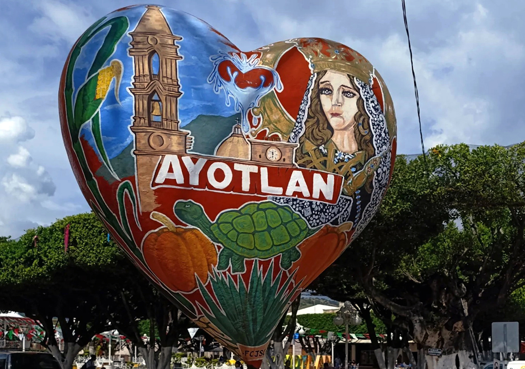
Town Ayotlán, Jalisco
Municipal seat in Jalisco's Ciénega, known for its August Día de Campo on Cerro del Caracol and the Virgen de la Soledad fiesta.
From Arandas: 45 min by car (36 km by road) How to get there ↓
Near here
See everything nearby ↓


Plan your visit to Ayotlán
Where to stay near Ayotlán
Compare hotels, posadas and guest houses in Ayotlán.
Tours to Ayotlán
Day trips around Jalpa de Cánovas sometimes stop in Ayotlán; a tour is the easy way to see it without a car.
How to get to Ayotlán
- From Arandas: about 45 min by road (~36 km)
- Nearest airport: León (Bajío) (BJX), 1 h 5 min by car to Jalpa de Cánovas
Links open a partner site. We may earn a commission if you book, at no cost to you.
About Ayotlán
Ayotlán is the seat of the municipality of the same name in eastern Jalisco, at about 1,600 m above sea level and not far from the borders with Guanajuato and Michoacán. The town had 13,810 inhabitants at the 2020 census. The name comes from Nahuatl ayotl, gourd or turtle, and is linked to the deep site ringed by hills that used to be largely flooded; a local spring feeds the valley and the Ciénega de Tlaxcala, a protected wetland of about 13 hectares. Until 1981 the town was called Ayo el Chico, a name the Spaniards gave it in the 16th century to tell it apart from a larger settlement near San Pedro Piedra Gorda, Guanajuato.
Before the conquest the Coinan valley lay under the lordship of Tototlán, and shrines to Ixtlacateolt stood on Cerro de las Villas. During the Mixtón War in 1541 the residents burned the church and their houses and withdrew to the Coinan peñol, where Viceroy Antonio de Mendoza defeated them on 26 October.
Today the economy mixes farming (maize, beans, chickpeas, maguey, barley), livestock, trade and clothing workshops, plus cold-cut packers and cajeta makers. The town has the Hacienda de San Vicente and several churches: the parishes of San Agustín, Nuestra Señora de Guadalupe and Santa Rita, the Ermita de la Soledad and the Capilla del Santo Niño. The image of the Virgen de la Soledad was crowned on 15 November 1947, and her fiesta, 7 to 15 November, brings processions, a night-time castillo of fireworks and fairground rides around the plaza.
The best-known date is the Día de Campo, on the first and last Sundays of August, with a parade of floats and charros; on the last Monday of the month families go up Cerro del Caracol to eat, hire bands and watch rodeos. The custom may go back to the Augustinian friars and their feast on 28 August, though its exact origin is not known.
How to get to Ayotlán
Drive from Arandas: 45 min, 36 km
Ayotlán is about 120 km from Guadalajara, roughly 1 h 50 min by car: take the 15D/80D toll road east toward Zapotlanejo, then federal highway 90 for the last 66 km or so. There is no direct bus from Guadalajara. The usual way is to leave the Nueva Central Camionera de Guadalajara (Module 1) with Flecha Amarilla or Coordinados for Atotonilco el Alto (about 1 h 30 min; Flecha Amarilla runs hourly) or for Arandas (Coordinados, about 2 h 30 min), then continue by taxi to Ayotlán, about 57 min from Atotonilco el Alto. Route-planner schedules and fares are estimates, so confirm with the line. Zamora, Michoacán, is about 110 km by road (about 1 h 35 min).
Directions to Ayotlán on Google Maps
Distances are in a straight line; the road is usually longer.
Links open a partner site. We may earn a commission if you book, at no cost to you.
From the nearest cities to Ayotlán
- Arandas · 36 km by road, 45 min
- La Piedad · 46 km by road, 45 min
- Ocotlán · 84 km by road, 1 h 15 min
Drive times by road from OpenStreetMap, without traffic or stops. Times marked ~ are estimated from the straight-line distance.
Before you go to Ayotlán: hours, prices and tips
- Best season
- Virgen de la Soledad, 7 to 15 November; Virgen de Guadalupe, 3 to 12 December; Día de Campo, first and last Sundays of August. Wikipedia · checked Oct 2026
Hours and prices change, especially around holidays. Each fact links to where we checked it.
Visiting Ayotlán: what to see and do
Main plaza and the parish of San Agustín.
Hacienda de San Vicente.
Cerro del Caracol, setting of the August Día de Campo.
Ciénega de Tlaxcala, a protected wetland beside the town.
Presa Santa Rita and the Dulces hot spring.
Fiesta of the Virgen de la Soledad, 7 to 15 November.
Plan your trip
Places to stay in Ayotlán
Compare hotels, posadas, and rentals in and around Ayotlán.
Tours & activities
Day trips around Jalpa de Cánovas sometimes stop in Ayotlán; a tour is the easy way to see it without a car.
Rental cars
Pick up a car at BJX (León (Bajío)): about 1 h 5 min by road to Jalpa de Cánovas, then 53 km more to Ayotlán, on your own schedule.
Flights
The nearest airport with scheduled flights is León (Bajío) (BJX), about 1 h 5 min by road from Jalpa de Cánovas, the base for Ayotlán.
Mobile data
Signal can drop away from Jalpa de Cánovas: download a map of the way to Ayotlán before you set out, or carry an eSIM with data.
Links open a partner site. We may earn a commission if you book, at no cost to you.
When to go to Ayotlán mild
Ayotlán shares the climate of Jalpa de Cánovas, 53 km away. The best months to visit are January, February, March, and April.
See the month-by-month climate of Jalpa de Cánovas
Weather in Ayotlán now and the next 7 days
Live forecast from Open-Meteo. Chance of rain is the day's highest.
The closest Pueblo Mágico: Jalpa de Cánovas

Jalpa de Cánovas is the Pueblo Mágico closest to Ayotlán, with places to stay, food, and more to see.
Also close to
- Jiquilpan · Michoacán · 72 km away
Closest to Ayotlán
-
Huáscato · Village · 10 km away
-
Jesús María · Town · 14 km away
-
Atotonilco el Alto · Town · 19 km away
-
Arandas · Town · 20 km away
-
Degollado · Town · 22 km away
-
La Barca · City · 35 km away
-
Capilla de Guadalupe · Town · 43 km away
-
Ciudad Manuel Doblado · Town · 45 km away


Near Ayotlán


Drive times by road from OpenStreetMap, without traffic. Times marked ~ are estimated from the straight-line distance.
Location from OpenStreetMap. Written by Puebloteca.