Town Santa Catarina Ixtepeji, Oaxaca Sierra Norte of Oaxaca
Zapotec seat in the Sierra Norte at about 1,900 m, in pine forest, with an 18th-century church and a famous colonial codex.
From Oaxaca: 45 min by car (43 km by road) How to get there ↓
Near here
See everything nearby ↓


Plan your visit to Santa Catarina Ixtepeji
Where to stay near Santa Catarina Ixtepeji
Compare hotels, posadas and guest houses in Santa Catarina Ixtepeji.
Tours to Santa Catarina Ixtepeji
Day trips around Capulálpam de Méndez sometimes stop in Santa Catarina Ixtepeji; a tour is the easy way to see it without a car.
 Tours from Oaxaca City
Hierve el Agua 2.5 hours, Mitla, Tule, Rugs and Mezcal for a Day
★ 4.9 (1,558) · From US$70
How to get to Santa Catarina Ixtepeji
- From Oaxaca: about 45 min by road (~43 km)
- Nearest airport: Oaxaca (OAX), 1 h 27 min by car to Capulálpam de Méndez
Links open a partner site. We may earn a commission if you book, at no cost to you.
Tours from Oaxaca City, near Santa Catarina Ixtepeji


Tours, prices and ratings from Viator, checked weekly. We may earn a commission if you book.
About Santa Catarina Ixtepeji
Ixtepeji sits at almost 1,900 metres in the Sierra Juárez, ringed by forest: 81% of the municipality is woodland, at altitudes from 1,400 to 3,300 metres. Zapotec oral tradition places its origins between the years 650 and 700, when three lords left Yolox with several families. The mission town was formally founded in 1565, split into five barrios (San Pedro, San Juan Evangelista, San Juan Bautista, San Nicolás and San Miguel). Cochineal dye followed and made the town an economic and cultural centre of the sierra, setting it for decades against Ixtlán over which would be district seat.
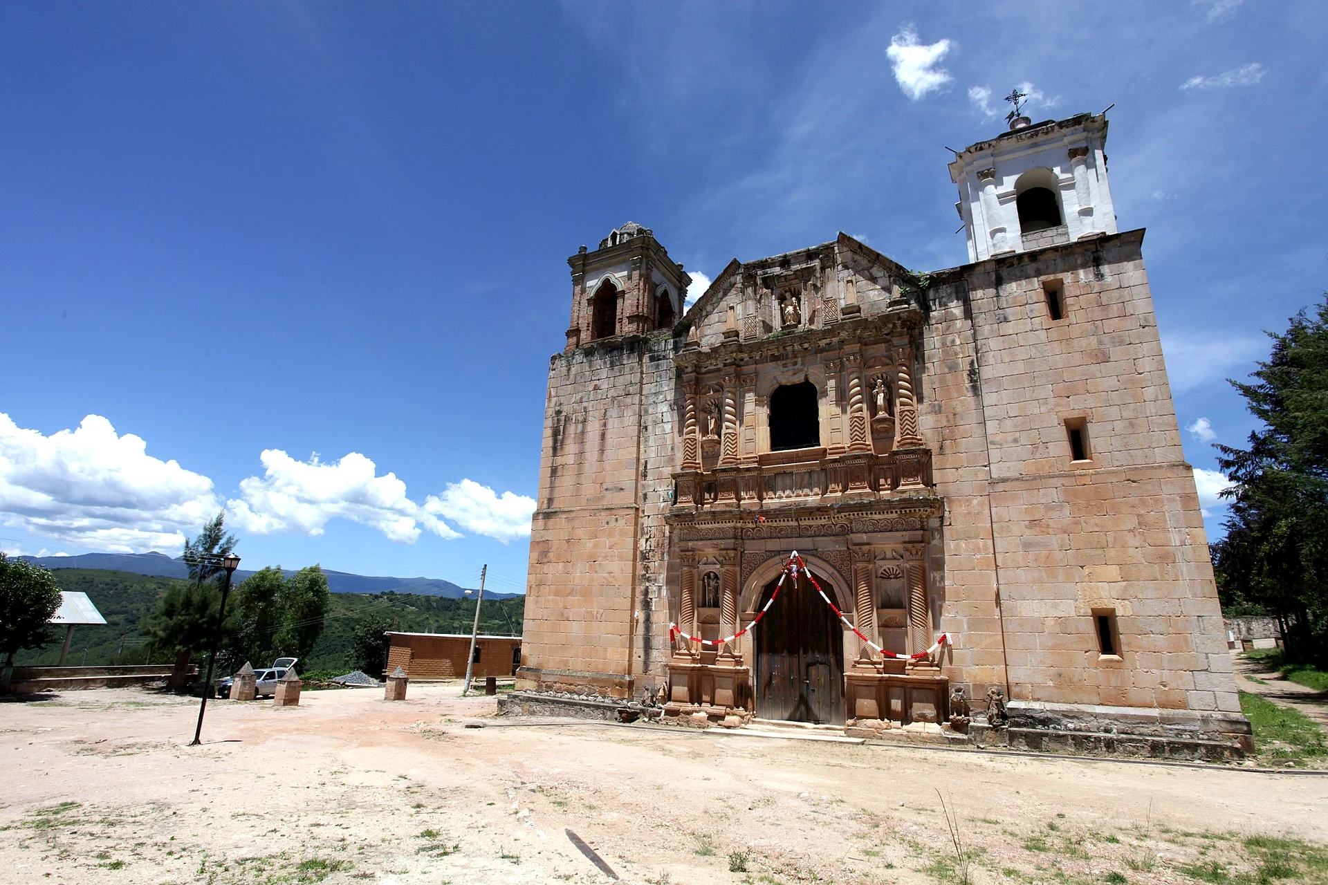
From that past survives the Codex of Santa Catarina Ixtepeji, a painted bilingual scroll in Spanish and Zapotec from the late 17th or early 18th century, with a map and part of the town's story; it resurfaced in 2012 in the American Geographical Society Library in Milwaukee. The parish church dates from the 18th century and was once the head of its curacy; at San Pedro Nexicho, a little over 2 km north, there is another from the 16th century with a portal bearing the image of Pope Julius III.
Today the forest pays the bills: there has been a forestry ejido since 1964 and a communal timber unit since 1984. Wood also becomes kitchen tools of palo de águila, such as spoons and molinillos. The table runs to mole, tamales and tepache, a wind band plays at fiestas, and the patron is Saint Catherine of Alexandria.
The locality had 741 inhabitants in 2020 (777 in 2010); the municipality, with 19 localities, had 2,633 in 2010. There are comedores in town, such as Comedor Jazmín and Comedor Charito, and from here you can walk up Cerro Cruz de Ceniza (2,424 m) in about 75 minutes.
How to get to Santa Catarina Ixtepeji
Drive from Oaxaca: 45 min, 43 km
From Oaxaca city climb federal Highway 175 toward Ixtlán and Guelatao; the town is about 45 km from Oaxaca. The highway passes some 3 km from the centre and a dirt road links it to the town. Pavement continues to Ixtepeji Cumbre, near 2,700 m, before crossing the divide toward Veracruz, so cars and motorbikes arrive without trouble; allow about 1 hour from Oaxaca for the climb (approx.). Capulálpam de Méndez, the nearest pueblo on our list, is about 19 km by road (about 20 minutes). We found no timetable or operator for a direct service to Ixtepeji: Sierra Norte vehicles leave Oaxaca toward Ixtlán, so you would get off at the junction and take a taxi or walk the last stretch; confirm locally at the second-class terminal or with the village comedores.
Directions to Santa Catarina Ixtepeji on Google Maps
Distances are in a straight line; the road is usually longer.
Links open a partner site. We may earn a commission if you book, at no cost to you.
From the nearest cities to Santa Catarina Ixtepeji
- Oaxaca · 43 km by road, 45 min
- Tuxtepec · 179 km by road, 3 h
- Tehuacán · about 205 km by road, ~3 h 5 min
Drive times by road from OpenStreetMap, without traffic or stops. Times marked ~ are estimated from the straight-line distance.
Before you go to Santa Catarina Ixtepeji: hours, prices and tips
- Rules
- The forest above La Mesita is a protected area; an old chain blocks vehicles and cyclists pay a small fee to pass. Bikepacking.com, La Magia de Ixtepeji (2021) · checked Oct 2026
Hours and prices change, especially around holidays. Each fact links to where we checked it.
Visiting Santa Catarina Ixtepeji: what to see and do
Visit the 18th-century church and its atrium.
Ask about the Codex of Santa Catarina Ixtepeji, the town's painted history.
Walk 2 km north to San Pedro Nexicho for its 16th-century church and the portal with Pope Julius III.
Climb Cerro Cruz de Ceniza (2,424 m), about 75 minutes on foot.
Buy spoons and molinillos of palo de águila.
Eat mole, tamales and tepache at a village comedor.
Plan your trip
Places to stay in Santa Catarina Ixtepeji
Compare hotels, posadas, and rentals in and around Santa Catarina Ixtepeji.
Tours & activities
Day trips around Capulálpam de Méndez sometimes stop in Santa Catarina Ixtepeji; a tour is the easy way to see it without a car.
Rental cars
Pick up a car at OAX (Oaxaca): about 1 h 27 min by road to Capulálpam de Méndez, then 13 km more to Santa Catarina Ixtepeji, on your own schedule.
Flights
The nearest airport with scheduled flights is Oaxaca (OAX), about 1 h 27 min by road from Capulálpam de Méndez, the base for Santa Catarina Ixtepeji.
Mobile data
Signal can drop away from Capulálpam de Méndez: download a map of the way to Santa Catarina Ixtepeji before you set out, or carry an eSIM with data.
Links open a partner site. We may earn a commission if you book, at no cost to you.
When to go to Santa Catarina Ixtepeji cool
Santa Catarina Ixtepeji shares the climate of Capulálpam de Méndez, 13 km away. The best months to visit are January, February, March, and December.
See the month-by-month climate of Capulálpam de Méndez
Weather in Santa Catarina Ixtepeji now and the next 7 days
Live forecast from Open-Meteo. Chance of rain is the day's highest.
The closest Pueblo Mágico: Capulálpam de Méndez

Capulálpam de Méndez is the Pueblo Mágico closest to Santa Catarina Ixtepeji, with places to stay, food, and more to see.
Also close to
- Mitla · Oaxaca · 44 km away
Closest to Santa Catarina Ixtepeji
-
Guelatao de Juárez · Town · 9 km away
-
Lachatao · Town · 9 km away
-
Ixtlán de Juárez · Town · 11 km away
-
Santa María Jaltianguis · Town · 11 km away
-
San Juan Evangelista Analco · Village · 16 km away
-
Pueblos Mancomunados · Nature reserve · 20 km away
-
San Antonio Cuajimoloyas · Village · 20 km away
-
Llano Grande · Village · 21 km away

Near Santa Catarina Ixtepeji


Drive times by road from OpenStreetMap, without traffic. Times marked ~ are estimated from the straight-line distance.
Location from OpenStreetMap. Written by Puebloteca.