


Landmark Mazatlán, Sinaloa Municipality of Mazatlán Mazatlán and southern Sinaloa
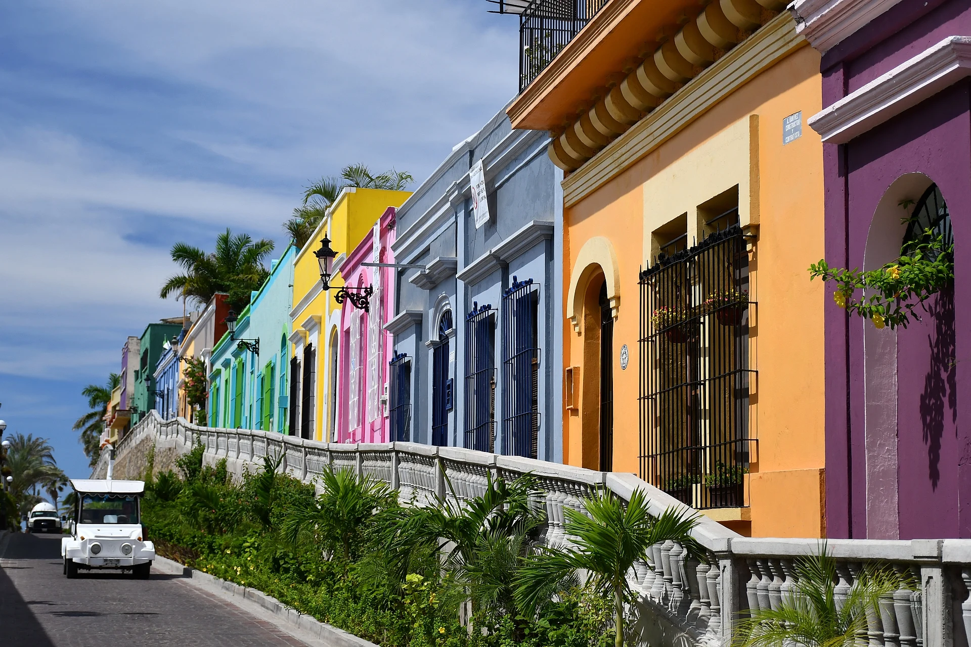
Mazatlán's old town: 180 blocks of 19th-century merchant houses, plazas, a cathedral, an iron market and a theatre, protected as a heritage zone since 2001.
From Culiacán: 2 h 50 min by car (220 km by road) How to get there ↓
Near here
See everything nearby ↓


Plan your visit to Centro Histórico de Mazatlán
Where to stay near Centro Histórico de Mazatlán
Compare hotels, posadas and guest houses in Centro Histórico de Mazatlán.
Tours to Centro Histórico de Mazatlán
Look for tours of the area around El Rosario that stop at Centro Histórico de Mazatlán.
 Tours from Mazatlan
Old Town Mazatlan Segway Tour
★ 5.0 (396) · From US$72
How to get to Centro Histórico de Mazatlán
- From Culiacán: about 2 h 50 min by road (~220 km)
- Nearest airport: Mazatlán (MZT), 45 min by car to El Rosario
Links open a partner site. We may earn a commission if you book, at no cost to you.
Tours from Mazatlan, near Centro Histórico de Mazatlán


Tours, prices and ratings from Viator, checked weekly. We may earn a commission if you book.
About Centro Histórico de Mazatlán
The Centro Histórico is the old port town of Mazatlán, on the narrow southern end of the peninsula where the city began, between the harbour and the Paseo Olas Altas. In 2001 the federal government declared it a Zone of Historic Monuments, under the care of INAH: a single area of 1.145 km² taking in 180 city blocks. Most of its buildings date from the 19th century and the first quarter of the 20th, and mix academic styles with regional ways of building, from tall shuttered doorways to cast-iron balconies.
The district grew rich on trade. In the 1800s merchants and investors from Germany, France, Spain, England, Italy, the United States and other parts of Mexico ran the port's business, and they built their warehouses and homes around the new plazas. After decades of decline in the 20th century, residents, the city and private owners restored much of it, and today the brightly painted façades, cobbled streets and lit-up buildings at night are what draw visitors. Walking tours, food tours and Segway rides through the old town are among the most booked activities in the city.
The main sights are close together. The Catedral Basílica de la Inmaculada Concepción faces Plazuela República, next to the Palacio Municipal. A few blocks south-west, Plazuela Machado, laid out in 1837, is ringed by restaurants, cafés, galleries and bars, with the Teatro Ángela Peralta on Calle Carnaval beside it. The Mercado Pino Suárez, an iron-framed market opened in 1899, sells fruit, meat, crafts and clothing, and the Templo de San José is the other notable church inside the zone. From the western edge of the district it is only a short walk down to the sea at Olas Altas.
How to get to Centro Histórico de Mazatlán
Drive from Culiacán: 2 h 50 min, 220 km
The old town is at the southern end of the city, a few blocks inland from the Paseo Olas Altas. From the Zona Dorada, the green tourist buses and the "Sábalo-Centro" city buses run along the malecón to the centre, and pulmonías and Uber are easy to find. From Plazuela República, Calle Ángel Flores leads west to the sea at Olas Altas.
Directions to Centro Histórico de Mazatlán on Google Maps
Distances are in a straight line; the road is usually longer.
Links open a partner site. We may earn a commission if you book, at no cost to you.
From the nearest cities to Centro Histórico de Mazatlán
- Culiacán · 220 km by road, 2 h 50 min
- Tepic · 274 km by road, 3 h 35 min
- Durango · 250 km by road, 3 h 40 min
Drive times by road from OpenStreetMap, without traffic or stops. Times marked ~ are estimated from the straight-line distance.
Visiting Centro Histórico de Mazatlán: what to see and do
Start at Plazuela República with the cathedral and the Palacio Municipal.
Browse the fruit stalls and crafts of the iron-framed Mercado Pino Suárez (1899).
Have dinner on Plazuela Machado and look in at the Teatro Ángela Peralta.
Walk Calle Ángel Flores for its painted façades on the way down to Olas Altas.
Visit the free Museo de Arte de Mazatlán and the Museo Arqueológico near the seafront.
Come back after dark, when the old buildings are lit up.
Plan your trip
Places to stay in Centro Histórico de Mazatlán
Compare hotels, posadas, and rentals in and around Centro Histórico de Mazatlán.
Tours & activities
Look for tours of the area around El Rosario that stop at Centro Histórico de Mazatlán.
Rental cars
Pick up a car at MZT (Mazatlán): about 45 min by road to El Rosario, then 62 km more to Centro Histórico de Mazatlán, on your own schedule.
Flights
The nearest airport with scheduled flights is Mazatlán (MZT), about 45 min by road from El Rosario, the base for Centro Histórico de Mazatlán.
Mobile data
Signal can drop away from El Rosario: download a map of the way to Centro Histórico de Mazatlán before you set out, or carry an eSIM with data.
Links open a partner site. We may earn a commission if you book, at no cost to you.
Photos
When to go to Centro Histórico de Mazatlán warm
Centro Histórico de Mazatlán shares the climate of El Rosario, 62 km away. The best months to visit are January, March, November, and December.
See the month-by-month climate of El Rosario
Weather in Centro Histórico de Mazatlán now and the next 7 days
Live forecast from Open-Meteo. Chance of rain is the day's highest.
The closest Pueblo Mágico: El Rosario

El Rosario is the Pueblo Mágico closest to Centro Histórico de Mazatlán, with places to stay, food, and more to see.
Closest to Centro Histórico de Mazatlán
-
Catedral Basílica de la Inmaculada Concepción · Landmark · 0 km away
-
Mercado Pino Suárez · Landmark · 0 km away
-
Plazuela Machado · Landmark · 0 km away
-
Teatro Ángela Peralta · Landmark · 0 km away
-
El Clavadista · Landmark · 1 km away
-
Museo Nacional de la Ballena · Landmark · 1 km away
-
Observatorio 1873 · Landmark · 1 km away
-
Playa Norte · Beach · 1 km away


Near Centro Histórico de Mazatlán
-
Isla de Venados · Island · Sinaloa
25 min: drive to Playa Gaviotas, Zona Dorada (beach by Hotel El Cid Castilla), then 15 min by boat -
Isla de Pájaros · Island · Sinaloa
25 min: drive to Playa Gaviotas, Zona Dorada, then 15 min by boat


Drive times by road from OpenStreetMap, without traffic. Times marked ~ are estimated from the straight-line distance.
Location from OpenStreetMap. Written by Puebloteca.