

A region of Sinaloa
The port city of Mazatlán, its beaches and the islands off its shore, and the towns of the southern Sinaloa coast and the Sierra Madre foothills inland: Concordia, Copala, El Quelite, El Rosario and the estuaries down to Teacapán.
1 Pueblo Mágico · 28 places to visit
Pueblos Mágicos in Mazatlán and southern Sinaloa

Map
Places to visit in Mazatlán and southern Sinaloa 28
28 places with their own page, grouped by kind.
Landmarks and museums · 12 Beaches · 5 Villages · 5 Islands · 2 Cities · 1 Nature reserves · 1 Towns · 1 Viewpoints · 1
Landmarks and museums
-
Catedral Basílica de la Inmaculada Concepción · Landmark · Sinaloa
Mazatlán's twin-towered cathedral, built over four decades and finished in 1899, with a gilded interior and a Cavaillé-Coll organ from Paris. -
Centro Histórico de Mazatlán · Landmark · Sinaloa
Mazatlán's old town: 180 blocks of 19th-century merchant houses, plazas, a cathedral, an iron market and a theatre, protected as a heritage zone since 2001. -
El Clavadista · Landmark · Sinaloa
The cliff divers' rock on Mazatlán's seafront, where local divers leap about 14 m into shallow surf, timing each jump to an incoming wave. -
Gran Acuario Mazatlán · Landmark · Sinaloa
Mazatlán's big aquarium of the Sea of Cortez, opened in 2023 in Parque Central, with sharks, rays, sea lions and penguins in a Tatiana Bilbao building. -
Malecón de Mazatlán · Landmark · Sinaloa
Mazatlán's seafront promenade, about 21 km of walkway and bike lane from the old town to the hotel zone, lined with monuments and sunset views. -
Mercado Pino Suárez · Landmark · Sinaloa
Mazatlán's iron-and-steel central market of 1899 in the historic center, full of produce, seafood, crafts and cheap breakfast counters. -
Museo Nacional de la Ballena · Landmark · Sinaloa
Mexico's national whale museum, opened in 2024 in the Observatorio 1873 park on Cerro del Vigía, with whale skeletons and winter whale-watching trips. -
Observatorio 1873 · Landmark · Sinaloa
A 19th-century lookout and weather observatory on Cerro del Vigía, now a park with an award-winning funicular, gardens, a museum and sea views. -
Plazuela Machado · Landmark · Sinaloa
Mazatlán's oldest square, laid out in 1837 by a silver and pearl merchant, with an 1881 iron kiosk and terrace restaurants all around. -
Teatro Ángela Peralta · Landmark · Sinaloa
Mazatlán's 19th-century theatre, wrecked by a hurricane in 1975 and reopened in 1992: an 841-seat hall that is the city's main stage today. -
Vinata Los Osuna · Landmark · Sinaloa
A working agave distillery in the hills by La Noria, north-east of Mazatlán, with guided tours of the old process and a tasting at the end. -
Zona Dorada · Landmark · Sinaloa
Mazatlán's Golden Zone, the hotel strip along Avenida Camarón Sábalo, with calm Playa Gaviotas, restaurants, bars and boats to Isla de Venados.



Beaches
-
Isla de la Piedra · Beach · Sinaloa
Mazatlán's long palm-backed beach across the harbor mouth, a few minutes by water taxi, with calm water, palapa seafood restaurants and horse rides. -
Playa Brujas · Beach · Sinaloa
A surf beach at Mazatlán's northern tip, by the rocks of Punta Cerritos, with tide pools, low-tide caves, a witch legend and quieter sand than the hotel zone. -
Playa Cerritos · Beach · Sinaloa
Mazatlán's long northern beach from the marina to Punta Cerritos, with firm sand for walking, steady surf, parasailing and nesting sea turtles. -
Playa Norte · Beach · Sinaloa
Mazatlán's fishermen's beach on the malecón by the old center, where pangas land the catch, families buy fresh fish and the Fishermen's Monument stands. -
Playa Olas Altas · Beach · Sinaloa
Mazatlán's historic town beach below the old centre: a 550 m bay of surf, sunsets and old seafront hotels where the city's beach tourism began.


Villages
-
Copala · Village · Sinaloa
A 16th-century silver-mining village in the Sierra Madre above Concordia, with a stone church on a hill, cobbled lanes and its famous banana pie. -
El Quelite · Village · Sinaloa
A cobblestoned Pueblo Señorial north of Mazatlán, known for its fresh cheese, home-style Sinaloan cooking and the Mesón de los Laureanos. -
La Noria · Village · Sinaloa
An old village in the foothills north-east of Mazatlán, known for its leather workshops, handmade huaraches and Sunday food market. -
Malpica · Village · Sinaloa
A small craft village on the road from Villa Unión to Concordia, known for handmade mosaic tiles, home-baked pan dulce and a living Way of the Cross. -
Mesillas · Village · Sinaloa
The furniture-making village of Concordia, a few kilometers from the town, with about 40 workshops and 25 showrooms of handmade wooden furniture.



Islands
-
Isla de Pájaros · Island · Sinaloa
The northernmost of Mazatlán's three islands, a protected seabird colony with the main brown pelican nesting site in the bay, seen from boats only. -
Isla de Venados · Island · Sinaloa
The middle and largest of Mazatlán's three protected islands, a short boat ride off the Zona Dorada, with a calm beach for swimming, snorkeling and kayaking.


Cities
-
Mazatlán · City · Sinaloa
Sinaloa's big Pacific port: a restored 19th-century old town, a seafront promenade of some 20 km, beaches, shrimp and one of Mexico's oldest carnivals.

Nature reserves
-
Estero del Yugo · Nature reserve · Sinaloa
A small coastal lagoon and dry-forest reserve in Cerritos, north Mazatlán, looked after by the CIAD research center and known as the city's bird sanctuary.

Towns
-
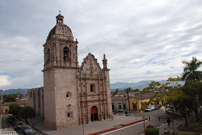
Concordia · Town · Sinaloa
A colonial mining town on the road from Mazatlán to Durango, with a carved baroque church, handmade furniture and a giant chair on its plaza.
Viewpoints
-
El Faro de Mazatlán · Viewpoint · Sinaloa
The lighthouse on top of 157 m Cerro del Crestón: a stepped climb of about 30 minutes to a glass lookout over the port, the city and the islands.

Top tours in Mazatlán and southern Sinaloa


Tours, prices and ratings from Viator, checked weekly. We may earn a commission if you book.
Getting around Mazatlán and southern Sinaloa
Fly into Mazatlán (MZT).
Cities to start from: Mazatlán
Most of the region is reached by road: a rental car is the easiest way to see several places in a day, and buses link the larger towns.
Also by boat or on foot (each page says from where): Isla de Pájaros, Isla de Venados.
When to visit Mazatlán and southern Sinaloa
Most of Mazatlán and southern Sinaloa is at its best in January, March, November, and December.
Month-by-month climate on each Pueblo Mágico's page: El Rosario