


Beach Mazatlán, Sinaloa Municipality of Mazatlán Mazatlán and southern Sinaloa
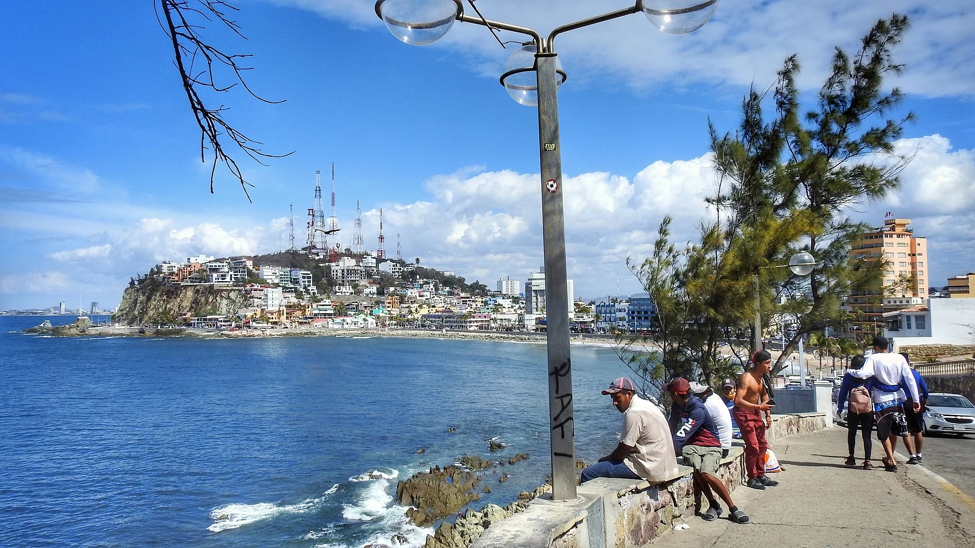
Mazatlán's historic town beach below the old centre: a 550 m bay of surf, sunsets and old seafront hotels where the city's beach tourism began.
From Culiacán: 2 h 55 min by car (221 km by road) How to get there ↓
Near here
See everything nearby ↓


Plan your visit to Playa Olas Altas
Where to stay near Playa Olas Altas
Compare hotels, posadas and guest houses in Playa Olas Altas.
Tours to Playa Olas Altas
Day trips and guided outings from El Rosario often include Playa Olas Altas; with a local guide you can get there without a car.
How to get to Playa Olas Altas
- From Culiacán: about 2 h 55 min by road (~221 km)
- Nearest airport: Mazatlán (MZT), 45 min by car to El Rosario
Links open a partner site. We may earn a commission if you book, at no cost to you.
About Playa Olas Altas
Playa Olas Altas is the beach of Mazatlán's old town, a small bay on the open Pacific just west of the historic centre, between Cerro del Vigía to the south and the rocky point of the Glorieta Sánchez Taboada and Cerro de la Nevería to the north. The beach and the seafront road above it, the Paseo Olas Altas, are about 550 m long. The name means "high waves", for the big swells that roll into the bay, and Olas Altas is one of only two streets in Mazatlán, with Calle Carnaval, that still carry their original names.
The promenade has deep roots. Work on a sea wall began here in 1830 to stop the floods that had buried Plazuela Machado in sand, and the road was later built on top of it. In March 1864 Cerro de la Nevería, at the north end, was a key point in the city's defence when French troops tried to land, and in August 1914 revolutionary forces took Mazatlán along this seafront, the last armed clash in the city during the Revolution. The poet Amado Nervo lived in a wooden house on Olas Altas in 1901.
Olas Altas is also where Mazatlán's beach tourism started. The Hotel Belmar, built in 1922 by the English mining magnate Louis Bradbury, was known as the hotel of the stars from the 1930s to the 1970s and still takes guests, and the 14-storey Hotel Freeman, built in 1949 by German architect Guillermo Freeman, was for years the tallest building in northern Mexico. Today the beach draws surfers for its waves and locals for the sunset, with views of Isla del Cardón, Isla de Lobos and El Faro. Along the promenade stand El Venadito, the Pedro Infante statue at the south end, the coats of arms of Sinaloa and Mazatlán, and a statue of composer Fernando Valadés facing the sea. The museums of art and archaeology are a block inland, and the promenade is one of the main stages of the Carnaval.
How to get to Playa Olas Altas
Drive from Culiacán: 2 h 55 min, 221 km
Olas Altas is at the southern end of the malecón, a few blocks west of Plazuela Machado; from Plazuela República, walk west along Calle Ángel Flores to the sea. From the Zona Dorada, the "Sábalo-Centro" buses, pulmonías and Uber run along the malecón to the old town.
Directions to Playa Olas Altas on Google Maps
Distances are in a straight line; the road is usually longer.
Links open a partner site. We may earn a commission if you book, at no cost to you.
From the nearest cities to Playa Olas Altas
- Culiacán · 221 km by road, 2 h 55 min
- Durango · 251 km by road, 3 h 40 min
- Tepic · 275 km by road, 3 h 40 min
Drive times by road from OpenStreetMap, without traffic or stops. Times marked ~ are estimated from the straight-line distance.
Visiting Playa Olas Altas: what to see and do
Watch the sunset over the bay, with El Faro and the islands offshore.
Surf or watch the surfers when the swell comes in.
Walk the 550 m Paseo Olas Altas past the Hotel Belmar and the old Hotel Freeman.
Find the statues of Pedro Infante and Fernando Valadés and El Venadito on the promenade.
Walk north to the cliff divers at the Glorieta Sánchez Taboada.
Plan your trip
Places to stay in Playa Olas Altas
Compare hotels, posadas, and rentals in and around Playa Olas Altas.
Tours & activities
Day trips and guided outings from El Rosario often include Playa Olas Altas; with a local guide you can get there without a car.
Rental cars
Pick up a car at MZT (Mazatlán): about 45 min by road to El Rosario, then 62 km more to Playa Olas Altas, on your own schedule.
Flights
The nearest airport with scheduled flights is Mazatlán (MZT), about 45 min by road from El Rosario, the base for Playa Olas Altas.
Travel insurance
If you plan on swimming or surfing at Playa Olas Altas, check that your policy covers it: some plans leave adventure activities out.
Mobile data
Signal can drop away from El Rosario: download a map of the way to Playa Olas Altas before you set out, or carry an eSIM with data.
Links open a partner site. We may earn a commission if you book, at no cost to you.
Photos
When to go to Playa Olas Altas warm
Playa Olas Altas shares the climate of El Rosario, 62 km away. The best months to visit are January, March, November, and December.
Playa Olas Altas is best for swimming and time on the water in the warmest months (May, June, and July); in the rainiest ones (July, August, and September) expect storms in the afternoon.
See the month-by-month climate of El Rosario
Weather in Playa Olas Altas now and the next 7 days
Live forecast from Open-Meteo. Chance of rain is the day's highest.
The closest Pueblo Mágico: El Rosario

El Rosario is the Pueblo Mágico closest to Playa Olas Altas, with places to stay, food, and more to see.
Closest to Playa Olas Altas
-
El Clavadista · Landmark · 0 km away
-
Plazuela Machado · Landmark · 0 km away
-
Teatro Ángela Peralta · Landmark · 0 km away
-
Catedral Basílica de la Inmaculada Concepción · Landmark · 1 km away
-
Centro Histórico de Mazatlán · Landmark · 1 km away
-
Mercado Pino Suárez · Landmark · 1 km away
-
Museo Nacional de la Ballena · Landmark · 1 km away
-
Observatorio 1873 · Landmark · 1 km away


Near Playa Olas Altas
-
Isla de Pájaros · Island · Sinaloa
25 min: drive to Playa Gaviotas, Zona Dorada, then 15 min by boat -
Isla de Venados · Island · Sinaloa
25 min: drive to Playa Gaviotas, Zona Dorada (beach by Hotel El Cid Castilla), then 15 min by boat


Drive times by road from OpenStreetMap, without traffic. Times marked ~ are estimated from the straight-line distance.
Lists with Playa Olas Altas
Beaches in Sinaloa · 9 Beaches near Mazatlán · 6Location from OpenStreetMap. Written by Puebloteca.