
Village Hermosillo, Sonora Municipality of Hermosillo
A 1936 ejido east of Hermosillo, just below El Molinito dam: irrigation ditches, fodder fields and the story of the Río Sonora's water.
From Hermosillo: about 25 min by road (~30 km) How to get there ↓
Near here
See everything nearby ↓


Plan your visit to Molino de Camou
Where to stay near Molino de Camou
Compare hotels, posadas and guest houses in Molino de Camou.
Tours to Molino de Camou
Day trips and guided outings from Ures often include Molino de Camou; with a local guide you can get there without a car.
How to get to Molino de Camou
- From Hermosillo: about 25 min by road (~30 km)
- Nearest airport: Hermosillo (HMO), 1 h 28 min by car to Ures
Links open a partner site. We may earn a commission if you book, at no cost to you.
About Molino de Camou
Molino de Camou, also known as San Isidro, is a farming ejido of about 1,277 people in the countryside east of Hermosillo, on Federal Highway 14 as it climbs toward Ures. It was created on 26 August 1936 in President Lázaro Cárdenas's land reform, and it has been run ever since as the Canal Bajo irrigation unit, with rights to water coming down the Río Sonora. Plots are small: most ejidatarios work four or five hectares.
The village's story is a story about water. In 1991 the Rodolfo Félix Valdés dam, known to everyone as El Molinito, opened just upstream, about two kilometers away, and it now also supplies part of Hermosillo's drinking water. Irrigation water dwindled over the years. Downstream of the dam, irrigated land fell from 9,000 to 3,000 hectares between 1994 and 2012, and in Molino de Camou farmers gave up wheat for fodder crops sold to local cattle ranchers. At times a farmer had to wait up to 24 hours for a turn to water a plot.
In 2014, when the mining spill poisoned the Río Sonora, the village wells were shut during the emergency and reopened months later. In June 2026 the state government handed over a 2.3 km water main with four outlets, a project worth more than 7.1 million pesos that serves 64 growers and some 400 hectares, with a second stage planned.
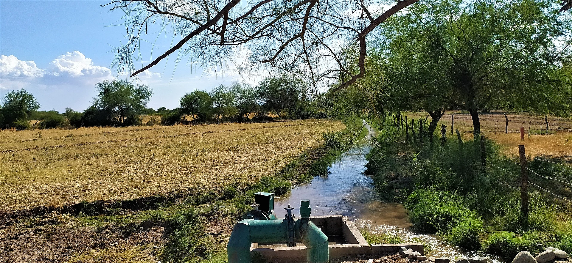
What a visitor sees is rural Sonora half an hour from the state capital: irrigation ditches shaded by mesquite, sluice gates and pumps, barbed-wire fences and cornfields along the river.
How to get to Molino de Camou
From Hermosillo, head east on Federal Highway 14, the Ures road; Molino de Camou sits right by the highway, 35 min and 29 km by road from central Hermosillo. Ures, the nearest Pueblo Mágico, is 50 min and 51 km further northeast on the same Highway 14. By public transport, several local lines run from the Central de Autobuses de Hermosillo to Ures along this road; ask the driver to let you off at El Molino. No local taxi or combi service is documented in the village.
Directions to Molino de Camou on Google Maps
Distances are in a straight line; the road is usually longer.
Links open a partner site. We may earn a commission if you book, at no cost to you.
From the nearest cities to Molino de Camou
- Hermosillo · about 30 km by road, ~25 min
- Guaymas · about 185 km by road, ~2 h 45 min
- Ciudad Obregón · about 270 km by road, ~4 h
Drive times by road from OpenStreetMap, without traffic or stops. Times marked ~ are estimated from the straight-line distance.
Visiting Molino de Camou: what to see and do
The Canal Bajo irrigation ditches, under the mesquite trees
Fodder fields and cornfields beside the Río Sonora
El Molinito dam (Rodolfo Félix Valdés), about 2 km upstream
The drive on to Ures along Highway 14
Plan your trip
Places to stay in Molino de Camou
Compare hotels, posadas, and rentals in and around Molino de Camou.
Tours & activities
Day trips and guided outings from Ures often include Molino de Camou; with a local guide you can get there without a car.
Rental cars
Pick up a car at HMO (Hermosillo): about 1 h 28 min by road to Ures, then 44 km more to Molino de Camou, on your own schedule.
Flights
The nearest airport with scheduled flights is Hermosillo (HMO), about 1 h 28 min by road from Ures, the base for Molino de Camou.
Mobile data
Signal can drop away from Ures: download a map of the way to Molino de Camou before you set out, or carry an eSIM with data.
Links open a partner site. We may earn a commission if you book, at no cost to you.
When to go to Molino de Camou warm
Molino de Camou shares the climate of Ures, 44 km away. The best months to visit are January, February, November, and December.
See the month-by-month climate of Ures
Weather in Molino de Camou now and the next 7 days
Live forecast from Open-Meteo. Chance of rain is the day's highest.
The closest Pueblo Mágico: Ures

Ures is the Pueblo Mágico closest to Molino de Camou, with places to stay, food, and more to see.
Closest to Molino de Camou
-
Presa Abelardo L. Rodríguez · Lake · 20 km away
-
Pesqueira · Town · 23 km away
-
Hermosillo · City · 24 km away
-
Villa de Seris · Landmark · 24 km away
Near Molino de Camou



Drive times by road from OpenStreetMap, without traffic. Times marked ~ are estimated from the straight-line distance.
Location from OpenStreetMap. Written by Puebloteca.