
Town Pajapan, Veracruz Los Tuxtlas Southern Veracruz (Olmec region)
Nahua town below the San Martín Pajapan volcano, close to Laguna del Ostión and the Jicacal beaches; a day trip from Coatzacoalcos.
From Coatzacoalcos: about 35 min by road (~40 km) How to get there ↓
Near here
See everything nearby ↓



Plan your visit to Pajapan
Where to stay near Pajapan
Compare hotels, posadas and guest houses in Pajapan.
Tours to Pajapan
Day trips around Veracruz sometimes stop in Pajapan; a tour is the easy way to see it without a car.
Links open a partner site. We may earn a commission if you book, at no cost to you.
About Pajapan
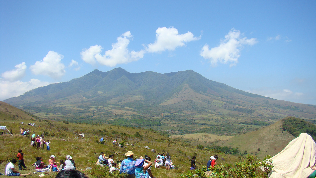
Pajapan is the seat of a Nahua municipality in southern Veracruz, on the lower slopes of the Sierra de Santa Marta at about 180 metres above sea level, with a little over 10,000 residents. Nahuatl is still spoken here, and the town's name comes from it. The climate is hot and very humid, with more than 2,400 mm of rain a year, and winter northerlies hit the coast hard. Behind the town rise the San Martín Pajapan and Pelón volcanoes, wrapped in tall rainforest.
What sets Pajapan apart is its land history. Between 1884 and 1886 the Nahuas split their communal land into five lots of 300 hectares each, a condueñazgo that kept collective ownership alive within the agrarian law of the day. In 1898 Minzapan became a congregation of Pajapan. Today people live from maize, plantain, Persian lime, mango, cattle and fishing.
The places to visit are on the coast and the lagoon. Laguna del Ostión, shared with Coatzacoalcos and open to the Gulf, is ringed with mangroves; Jicacal has thatched palapas, restaurants and a beach, and Sayultepec has a sea-turtle conservation camp. Look for garlic shrimp, fried mojarra and oysters. Town cooking includes taxgouil (fried pork with beans) and tatónil (meat in nixtamalised corn dough with achiote). Local crafts are woven baskets, clay comales and carved wooden figures. In the town centre a lookout is reached by 218 steps.
How to get to Pajapan
Pajapan is 55 min and 42 km by road from Minatitlán, the nearest city, and about 50 km from Coatzacoalcos. Take Federal Highway 180 (Veracruz-Coatzacoalcos) and turn off at Cosoleacaque toward the sierra. For Jicacal beach, in 2018 the route was the road to Barrillas and then a boat across Laguna del Ostión from the pier (under 10 minutes, 7 pesos then; check the current fare). I found no direct bus or combi from Coatzacoalcos: most visitors go by car or taxi, or ask at the Coatzacoalcos bus station and in Cosoleacaque about local transport.
Directions to Pajapan on Google Maps
Distances are in a straight line; the road is usually longer.
Links open a partner site. We may earn a commission if you book, at no cost to you.
From the nearest cities to Pajapan
- Coatzacoalcos · about 40 km by road, ~35 min
- Minatitlán · about 45 km by road, ~40 min
- San Andrés Tuxtla · about 75 km by road, ~1 h 10 min
Drive times by road from OpenStreetMap, without traffic or stops. Times marked ~ are estimated from the straight-line distance.
Before you go to Pajapan: hours, prices and tips
- Best season
- Patron-saint fiesta of San Juan de Dios: 6 to 8 May, with dances, a procession, music, comparsas, fireworks and a fair. Another fiesta, for San Antonio de Padua, runs 12 to 14 June. On 1 and 2 November families build altars in homes and cemeteries. Veracruz Tourism (veracruz.mx) · checked Oct 2026
Hours and prices change, especially around holidays. Each fact links to where we checked it.
Visiting Pajapan: what to see and do
Laguna del Ostión and its mangroves, crossed by boat on the way to Jicacal.
The beach and palapas of Jicacal, with oysters and fried mojarra.
The sea-turtle conservation camp at Sayultepec.
The lookout in the town centre, 218 steps up.
The San Martín Pajapan and Pelón volcanoes, seen from town.
Baskets, comales and carved wooden figures made locally.
Plan your trip
Places to stay in Pajapan
Compare hotels, posadas, and rentals in and around Pajapan.
Tours & activities
Day trips around Veracruz sometimes stop in Pajapan; a tour is the easy way to see it without a car.
Mobile data
Signal can drop away from Veracruz: download a map of the way to Pajapan before you set out, or carry an eSIM with data.
Links open a partner site. We may earn a commission if you book, at no cost to you.
Closest to Pajapan
-
Tatahuicapan · Town · 8 km away
-
Huazuntlán · Village · 16 km away
-
Buena Vista · Village · 26 km away
-
Chinameca · Town · 26 km away
-
Oteapan · Town · 29 km away
-
Coatzacoalcos · City · 30 km away
-
Cosoleacaque · Town · 30 km away
-
Catedral de Coatzacoalcos · Landmark · 32 km away


Near Pajapan




Drive times by road from OpenStreetMap, without traffic. Times marked ~ are estimated from the straight-line distance.
Location from OpenStreetMap. Written by Puebloteca.