


Lake Catemaco, Veracruz Municipality of Catemaco Los Tuxtlas
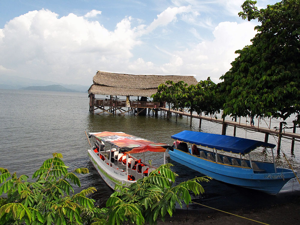
A volcanic lake of about 72 km² ringed by the hills of Los Tuxtlas, with launches out to islands of herons and stump-tailed macaques.
From San Andrés Tuxtla: 20 min by car (14 km by road) How to get there ↓
Near here
See everything nearby ↓


Plan your visit to Laguna de Catemaco
Where to stay near Laguna de Catemaco
Compare hotels, posadas and guest houses in Laguna de Catemaco.
Tours to Laguna de Catemaco
Day trips and guided outings from Veracruz often include Laguna de Catemaco; with a local guide you can get there without a car.
How to get to Laguna de Catemaco
- From San Andrés Tuxtla: about 20 min by road (~14 km)
Links open a partner site. We may earn a commission if you book, at no cost to you.
About Laguna de Catemaco
Lake Catemaco fills a basin in the centre of the Sierra de Los Tuxtlas in southern Veracruz, with the town of Catemaco on its western shore. Despite the name laguna it is a freshwater lake: it formed when lava from the San Martín Tuxtla volcano blocked its northern end, and it now lies about 340 m above sea level. It covers about 72.5 km², measures roughly 10 by 12 km, and has an irregular shoreline of about 50 km marked by old volcanic cones. It is shallow, averaging 7.6 m, with a maximum depth of 22 m in the channel between Agaltepec island and the town. Roads run almost all the way round it.
The lake drains through the Río Grande de Catemaco, which drops over the Salto de Eyipantla 11 km downstream. That waterfall has cut the lake off from the rest of the Papaloapan basin for a long time, and five of its fish species are found nowhere else. It is one of the most productive lakes in Mexico, and more than a thousand registered fishermen work it; the usual catch is the small topote, introduced tilapia and the tegogolo snail sold on the malecón. The forest that once covered its watershed has been heavily cut, and sediment now clouds the water. Sean Connery's Medicine Man and Mel Gibson's Apocalypto were both filmed around its shores.
Most visitors see it from one of the many launches that leave the Catemaco docks. The usual trip goes past Isla de las Garzas, where herons, cormorants and kingfishers roost, to Tanaxpillo, the Isla de los Changos. Stump-tailed macaques from Thailand were introduced to the lake in 1974 by the Universidad Veracruzana for conservation and behaviour studies, first on Totogochillo island; a second colony released on Tanaxpillo in the 1980s now has more than 60 animals. The larger island of Agaltepec, with native howler monkeys, is managed by the university for research. Many trips also take in the shrine of El Tegal, where the Virgin is said to have appeared, and the Nanciyaga reserve on the eastern shore.
How to get to Laguna de Catemaco
Drive from San Andrés Tuxtla: 20 min, 14 km
The lake is reached from the town of Catemaco on Federal Highway 180, about 170 km southeast of the city of Veracruz and 12 km east of San Andrés Tuxtla; ADO buses stop in town a short walk from the malecón. Boat trips leave from the docks on the Catemaco malecón. The road toward Coyame follows the eastern shore past Nanciyaga.
Directions to Laguna de Catemaco on Google Maps
Distances are in a straight line; the road is usually longer.
Links open a partner site. We may earn a commission if you book, at no cost to you.
From the nearest cities to Laguna de Catemaco
- San Andrés Tuxtla · 14 km by road, 20 min
- Minatitlán · 123 km by road, 2 h
- Coatzacoalcos · 143 km by road, 2 h 10 min
Drive times by road from OpenStreetMap, without traffic or stops. Times marked ~ are estimated from the straight-line distance.
Before you go to Laguna de Catemaco: hours, prices and tips
- Guide or tour
- Trips are run by local boatmen from the Catemaco docks; a launch holds about six passengers, and the price is agreed with the lancheros. Tours: Viator GetYourGuide México Desconocido · checked Oct 2026
- Rules
- Feeding the macaques is prohibited. Watch them from the boat, keep your distance and don't land on the islands; some animals can be aggressive. México Desconocido · checked Oct 2026
Hours and prices change, especially around holidays. Each fact links to where we checked it.
Visiting Laguna de Catemaco: what to see and do
Take a launch from the Catemaco docks around the islands.
Watch the macaques of Tanaxpillo (Isla de los Changos) from the boat.
See herons and cormorants roosting on Isla de las Garzas.
Stop at the shrine of El Tegal, where the Virgin is said to have appeared.
Visit the Nanciyaga reserve on the eastern shore.
Drive the road that circles most of the lake for views of the volcanic hills.
Plan your trip
Places to stay in Laguna de Catemaco
Compare hotels, posadas, and rentals in and around Laguna de Catemaco.
Tours & activities
Day trips and guided outings from Veracruz often include Laguna de Catemaco; with a local guide you can get there without a car.
Travel insurance
If you plan on swimming or kayaking at Laguna de Catemaco, check that your policy covers it: some plans leave adventure activities out.
Mobile data
Signal can drop away from Veracruz: download a map of the way to Laguna de Catemaco before you set out, or carry an eSIM with data.
Links open a partner site. We may earn a commission if you book, at no cost to you.
Photos
Closest to Laguna de Catemaco
-
Catemaco · Town · 5 km away
-
Nanciyaga · Nature reserve · 5 km away
-
Sontecomapan · Village · 11 km away
-
Calería · Village · 12 km away
-
Sihuapan · Village · 12 km away
-
Laguna Sontecomapan · Lagoon · 15 km away
-
Salto de Eyipantla · Waterfall · 15 km away
-
San Andrés Tuxtla · City · 16 km away


Near Laguna de Catemaco




Drive times by road from OpenStreetMap, without traffic. Times marked ~ are estimated from the straight-line distance.
Lists with Laguna de Catemaco
Lakes and Lagoons in Veracruz · 5Location from OpenStreetMap. Written by Puebloteca.