
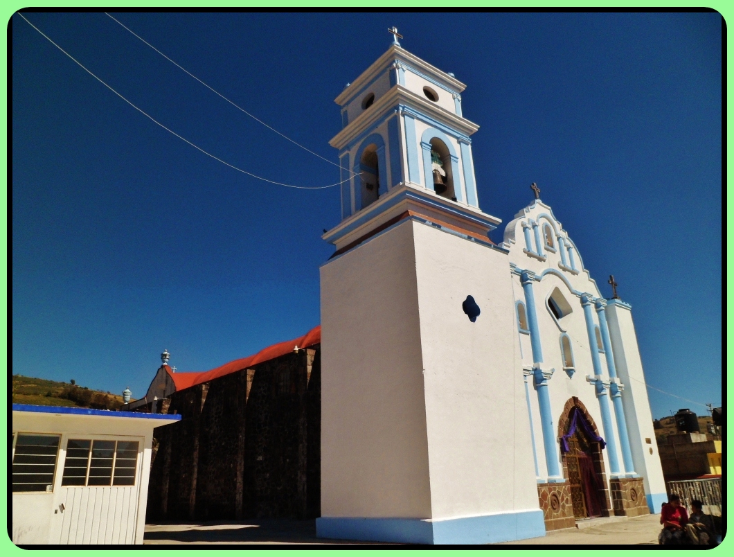
Town Joquicingo, Estado de México Toluca Valley Southern Estado de México
Seat of a small municipality in the south of the Toluca valley: Asunción feasts, arrieros and chinelo dances, and pyramids at Techuchulco.
From Toluca: 40 min by car (39 km by road) How to get there ↓
Near here
See everything nearby ↓


Plan your visit to Joquicingo
Where to stay near Joquicingo
Compare hotels, posadas and guest houses in Joquicingo.
Tours to Joquicingo
Day trips around Malinalco sometimes stop in Joquicingo; a tour is the easy way to see it without a car.
 Tours from Cuernavaca
3hr Cooking Class in Cuernavaca 8 Recipes and Bottomless Drinks
From US$59
How to get to Joquicingo
- From Toluca: about 40 min by road (~39 km)
- Nearest airport: Toluca (TLC), 1 h 14 min by car to Malinalco
Links open a partner site. We may earn a commission if you book, at no cost to you.
Tours from Cuernavaca, near Joquicingo


Tours, prices and ratings from Viator, checked weekly. We may earn a commission if you book.
About Joquicingo
Joquicingo de León Guzmán is the seat of the municipality of Joquicingo, 46 km² with 15,428 residents in 2020 and 13 localities; the seat itself has 4,832, and Techuchulco de Allende, the largest, has 5,044. It stands at about 2,630 m. It was once called San Miguel Zuquitzinco, a name in 1570 records; "León Guzmán" comes from Leonardo Francisco Guzmán Montes de Oca, born in Tenango del Valle in 1821. The etymology is disputed: Cecilio Robelo proposed Zoquitzinco, "in the little mud patch".
The municipality was constituted in 1832, lost the status after a cholera epidemic, and in 1847 was joined to Tenango del Valle. Near the centre a rock bears a child's footprint of pre-Hispanic date, known as "el piecito". The parish of the Asunción de María dominates the town and its feast is 15 August; the Señor del Huerto is honoured on 25 March, though the festivity is moved to the third week of May. Arrieros, chinelos, lobitos and moros dances predominate.
In Techuchulco a second Asunción church dates from the 17th century, and the bases of a circular pyramid dedicated to Ehécatl, Tláloc and Huitzilopochtli survive. Local food includes broad-bean gorditas and tortas, corn tamales with fresh broad beans, black and green mole, pipián and capultamal, and people make petates, carved-stone molcajetes and tissue-paper decorations.
How to get to Joquicingo
Drive from Toluca: 40 min, 39 km
Joquicingo lies about 30 km straight-line south of Toluca, in the south of the valley: by road allow roughly 45 minutes to 1 hour. The municipality borders Tenango del Valle to the west, Tianguistenco and Texcalyacac to the north, and Malinalco and Tenancingo to the south. Pueblos América gives 19 to 26 km (19 to 26 minutes) to Malinalco, though its page contradicts itself.
By public transport, go first to the Terminal de Toluca at Felipe Berriozábal 101, open 24 hours, which serves buses south (Wikivoyage mentions Ixtapan de la Sal); from Mexico City buses run to Toluca every few minutes from Observatorio and the Terminal Norte. There is no published published line all the way to Joquicingo; the sensible approach is to go via Tenango del Valle and ask there. For questions, the town hall is open Monday to Friday 9 am to 5 pm, tel. 714 140 0533.
Directions to Joquicingo on Google Maps
Distances are in a straight line; the road is usually longer.
Links open a partner site. We may earn a commission if you book, at no cost to you.
From the nearest cities to Joquicingo
- Toluca · 39 km by road, 40 min
- Cuernavaca · 52 km by road, 1 h 15 min
- Mexico City · 77 km by road, 1 h 20 min
Drive times by road from OpenStreetMap, without traffic or stops. Times marked ~ are estimated from the straight-line distance.
Before you go to Joquicingo: hours, prices and tips
- Best season
- Main feasts: Señor del Huerto (25 March, held in the third week of May), San Pedro y San Pablo in Techuchulco (29 June), Virgen de la Asunción (15 August, in the town and Techuchulco), San Miguel (29 September), Virgen de Guadalupe (12 December). Gobierno Municipal de Joquicingo · checked Oct 2026
Hours and prices change, especially around holidays. Each fact links to where we checked it.
Visiting Joquicingo: what to see and do
Parish of the Asunción de María in the town; feast on 15 August
The rock with a child's footprint, "el piecito", near the centre
Feast of the Señor del Huerto (25 March; held in the third week of May)
Arrieros, chinelo, lobitos and moros dances at patron feasts
Circular pyramid base and 17th-century church in Techuchulco
Day of the Dead altars with a marigold cross, 2 November
Plan your trip
Places to stay in Joquicingo
Compare hotels, posadas, and rentals in and around Joquicingo.
Tours & activities
Day trips around Malinalco sometimes stop in Joquicingo; a tour is the easy way to see it without a car.
Rental cars
Pick up a car at TLC (Toluca): about 1 h 14 min by road to Malinalco, then 12 km more to Joquicingo, on your own schedule.
Flights
The nearest airport with scheduled flights is Toluca (TLC), about 1 h 14 min by road from Malinalco, the base for Joquicingo.
Mobile data
Signal can drop away from Malinalco: download a map of the way to Joquicingo before you set out, or carry an eSIM with data.
Links open a partner site. We may earn a commission if you book, at no cost to you.
When to go to Joquicingo mild
Joquicingo shares the climate of Malinalco, 12 km away. The best months to visit are January, February, March, and December.
See the month-by-month climate of Malinalco
Weather in Joquicingo now and the next 7 days
Live forecast from Open-Meteo. Chance of rain is the day's highest.
The closest Pueblo Mágico: Malinalco

Malinalco is the Pueblo Mágico closest to Joquicingo, with places to stay, food, and more to see.
Also close to
- Metepec · Estado de México · 23 km away
- Ixtapan de la Sal · Estado de México · 27 km away
- Tonatico · Estado de México · 31 km away
- Xochitepec · Morelos · 37 km away
- Tepoztlán · Morelos · 46 km away
Closest to Joquicingo
-
Santa María Jajalpa · Village · 7 km away
-
Tenango de Arista · Town · 8 km away
-
San Bartolomé Atlatlahuca · Village · 9 km away
-
Teotenango · Archaeological site · 10 km away
-
Tenancingo · Town · 12 km away
-
Almoloya del Río · Town · 13 km away
-
San Antonio la Isla · Town · 13 km away
-
Santa Ana Ixtlahuatzingo · Village · 13 km away


Near Joquicingo




Drive times by road from OpenStreetMap, without traffic. Times marked ~ are estimated from the straight-line distance.
Location from OpenStreetMap. Written by Puebloteca.