Town San Antonio la Isla, Estado de México Toluca Valley
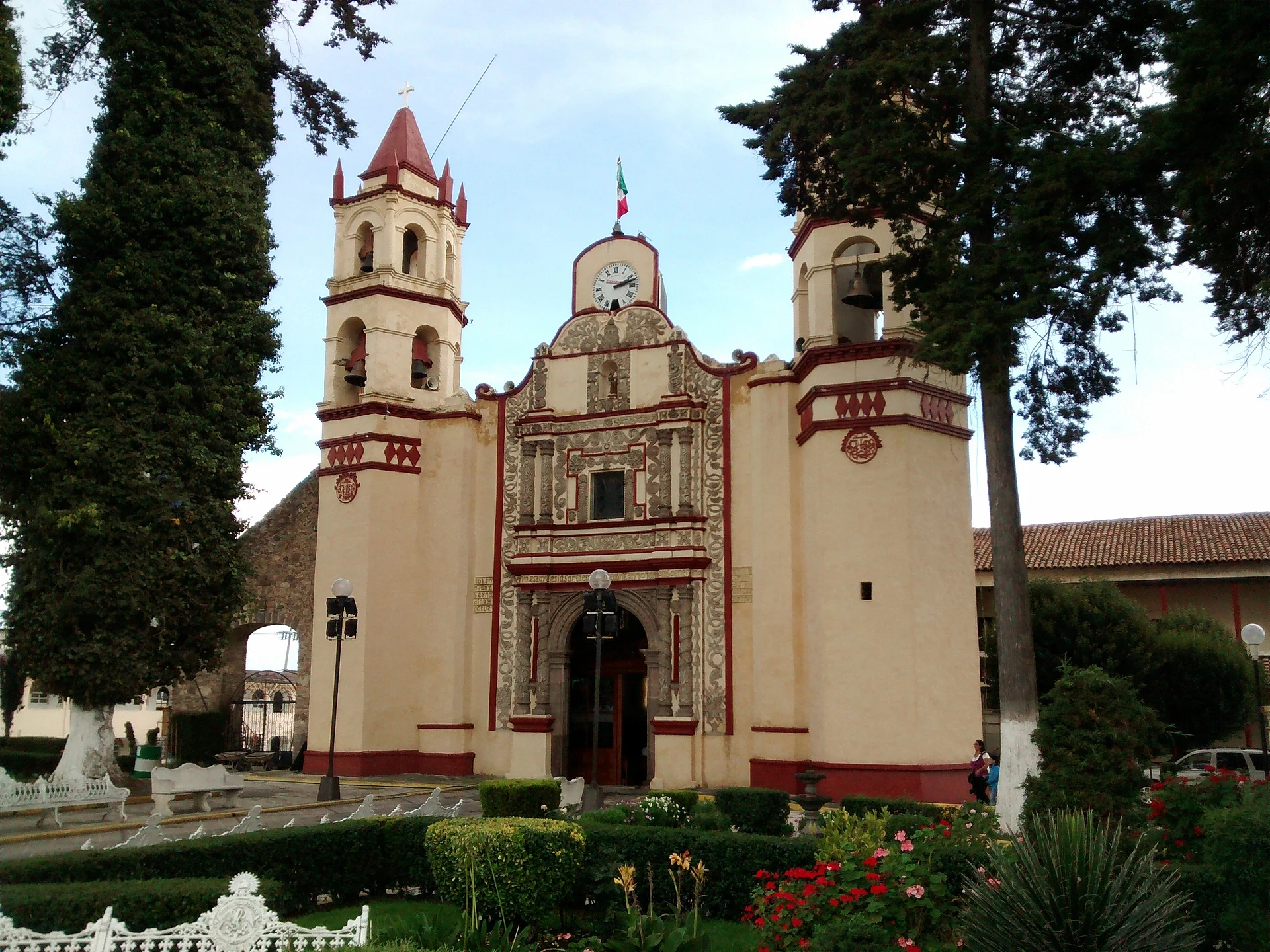
Municipal seat in the south of the Toluca valley, known for hand-made wooden toys, a baroque parish church and a museum with a local codex.
From Toluca: 15 min by car (19 km by road) How to get there ↓
Near here
See everything nearby ↓


Plan your visit to San Antonio la Isla
Where to stay near San Antonio la Isla
Compare hotels, posadas and guest houses in San Antonio la Isla.
Tours to San Antonio la Isla
Day trips around Metepec sometimes stop in San Antonio la Isla; a tour is the easy way to see it without a car.
 Tours from Cuernavaca
3hr Cooking Class in Cuernavaca 8 Recipes and Bottomless Drinks
From US$59
How to get to San Antonio la Isla
- From Toluca: about 15 min by road (~19 km)
- Nearest airport: Toluca (TLC), 17 min by car to Metepec
Links open a partner site. We may earn a commission if you book, at no cost to you.
Tours from Cuernavaca, near San Antonio la Isla


Tours, prices and ratings from Viator, checked weekly. We may earn a commission if you book.
About San Antonio la Isla
San Antonio la Isla is the seat of the municipality of the same name, at the far southern end of the Toluca valley, 2,590 metres above sea level. The 2020 census counted 17,075 people; in 1900 there were 1,148, and the sharpest jump came between 1970 and 1980, when the population nearly tripled. The name pairs the patron saint, Anthony of Padua, with the island the settlement stood on before the Spanish conquest. The older name, Techialoyan, already appears in the Codex Mendoza and is usually rendered "place of those who watch"; its glyph shows an eye on the tip of a pyramid floating on water.
The first inhabitants were Matlatzinca, followed by Otomí, and the town fell to the Aztecs under Axayácatl. San Antonio Techialoyan was officially recognised as a town in 1603, and in the 17th century it ran as a semi-independent Indian republic, according to the Codex of San Antonio Techialoyan. For most of its history it answered to Calimaya; the municipality was created by decree in 1847. During the War of Independence Miguel Hidalgo came through, recruiting men on his way to Tianguistenco.
Today it calls itself the cradle of traditional toys: families who have carved for generations turn out spinning tops, cup-and-ball toys, yo-yos, pirinolas, little wooden cars and powder boxes, mostly in wood but also bone and horn. The Plaza de las Artesanías and the craft corridor are where to buy them. To eat, try barbacoa with consomé and the usual antojitos: quesadillas, tlacoyos, sopes, gorditas and tamales.
How to get to San Antonio la Isla
Drive from Toluca: 15 min, 19 km
San Antonio la Isla lies south of Toluca, at the southern end of the valley. The sources disagree on timing: Food and Pleasure gives about 20 minutes from downtown Toluca and 1.5 hours from Mexico City, while Posta says roughly an hour from Toluca; allow for traffic and check the route on the day. In a straight line it is about 17 km from Toluca and about 10 km from Metepec, the nearest pueblo on our list (roughly 10 minutes by car). Without a car, Toluca is the base: the El Insurgente interurban train (Observatorio–Zinacantepec, about 50 minutes from Observatorio to Toluca, trains every 5 to 7 minutes) has stations at Toluca Centro and Metepec, and from there you continue by taxi or local transport. We found no source for the bus routes and fares to the town, so ask at the Toluca terminal or at the station.
Directions to San Antonio la Isla on Google Maps
Distances are in a straight line; the road is usually longer.
Links open a partner site. We may earn a commission if you book, at no cost to you.
From the nearest cities to San Antonio la Isla
- Toluca · 19 km by road, 15 min
- Mexico City · 73 km by road, 1 h 15 min
- Cuernavaca · 73 km by road, 1 h 30 min
Drive times by road from OpenStreetMap, without traffic or stops. Times marked ~ are estimated from the straight-line distance.
Visiting San Antonio la Isla: what to see and do
Buy wooden toys (tops, cup-and-ball games, yo-yos, little cars) at the Plaza de las Artesanías and the craft corridor workshops.
Step inside the baroque church of San Antonio de Padua.
Visit the Museo Municipal Techialoyan-Tepemaxalco, with archaeological pieces, a mural and a codex on the town's history.
See the church of San Lucas Evangelista as well.
Rest at Parque Las Ranas, with palapas and a children's area, or at the Parque Municipal Villa San Antonio la Isla.
Try barbacoa with consomé and the local antojitos.
Plan your trip
Places to stay in San Antonio la Isla
Compare hotels, posadas, and rentals in and around San Antonio la Isla.
Tours & activities
Day trips around Metepec sometimes stop in San Antonio la Isla; a tour is the easy way to see it without a car.
Rental cars
Pick up a car at TLC (Toluca): about 17 min by road to Metepec, then 10 km more to San Antonio la Isla, on your own schedule.
Flights
The nearest airport with scheduled flights is Toluca (TLC), about 17 min by road from Metepec, the base for San Antonio la Isla.
Mobile data
Signal can drop away from Metepec: download a map of the way to San Antonio la Isla before you set out, or carry an eSIM with data.
Links open a partner site. We may earn a commission if you book, at no cost to you.
When to go to San Antonio la Isla cool
San Antonio la Isla shares the climate of Metepec, 10 km away. The best months to visit are January, February, March, and December.
See the month-by-month climate of Metepec
Weather in San Antonio la Isla now and the next 7 days
Live forecast from Open-Meteo. Chance of rain is the day's highest.
The closest Pueblo Mágico: Metepec

Metepec is the Pueblo Mágico closest to San Antonio la Isla, with places to stay, food, and more to see.
Also close to
- Malinalco · Estado de México · 25 km away
- Ixtapan de la Sal · Estado de México · 37 km away
- Tonatico · Estado de México · 41 km away
- Xochitepec · Morelos · 49 km away
- Tepoztlán · Morelos · 53 km away
Closest to San Antonio la Isla
-
Chapultepec · Village · 4 km away
-
Calimaya · Town · 5 km away
-
San Mateo Mexicaltzingo · Town · 5 km away
-
Santa María Jajalpa · Village · 7 km away
-
Tenango de Arista · Town · 7 km away
-
Teotenango · Archaeological site · 7 km away
-
Almoloya del Río · Town · 8 km away
-
San Francisco Putla · Village · 8 km away


Near San Antonio la Isla


Drive times by road from OpenStreetMap, without traffic. Times marked ~ are estimated from the straight-line distance.
Location from OpenStreetMap. Written by Puebloteca.