


City Chilapa de Álvarez, Guerrero Central Guerrero
Highland city famous for its Sunday tianguis, held since 1533: Nahua villages sell palm weaving, masks, pottery and food beside a vast cathedral.
From Chilpancingo: 55 min by car (64 km by road) How to get there ↓
Near here
See everything nearby ↓


Plan your visit to Chilapa de Álvarez
Where to stay near Chilapa de Álvarez
Compare hotels, posadas and guest houses in Chilapa de Álvarez.
Tours to Chilapa de Álvarez
Day trips and guided outings from Guerrero often include Chilapa de Álvarez; with a local guide you can get there without a car.
How to get to Chilapa de Álvarez
- From Chilpancingo: about 55 min by road (~64 km)
Links open a partner site. We may earn a commission if you book, at no cost to you.
About Chilapa de Álvarez
Chilapa de Álvarez, usually just Chilapa, is a city of about 34,000 people in the hills of central-eastern Guerrero, around 54 km from Chilpancingo on the road to Tlapa, at about 1,400 m above sea level. The name comes from the Nahuatl Chilapan, read either as 'over the red water' or 'place of chilli fields'; 'de Álvarez' honours General Juan Álvarez. Augustinian friars founded the present town on 5 October 1533, bringing people down from the hill of Chilapantepetl to the valley, and that date is still celebrated as the city's founding. Chilapa was fought over by insurgents and royalists in the War of Independence and was taken by Morelos in 1811.
The city's great draw is its Sunday tianguis, said to have run since the friars' arrival in 1533 and considered the largest and oldest market in Guerrero. From about 6am every Sunday, thousands of traders, many of them Nahua farmers and artisans from Zitlala, José Joaquín de Herrera, Tlapa, Ahuacuotzingo, Olinalá and Chilapa's own villages, set out their goods around the Eucaria Apreza roundabout: hats, bags, mats and figures woven from palm and corn husk, tiger and tlacololero dance masks, painted clay pots and cazuelas, Olinalá lacquer boxes, embroidered blouses and the dresses of Acatlán, wooden furniture, chillies, beans, fruit, turkeys and firewood. Food stalls sell pozole with pig's trotters, green pozole, red mole, tamales and mezcal, and some trading is still done by barter.
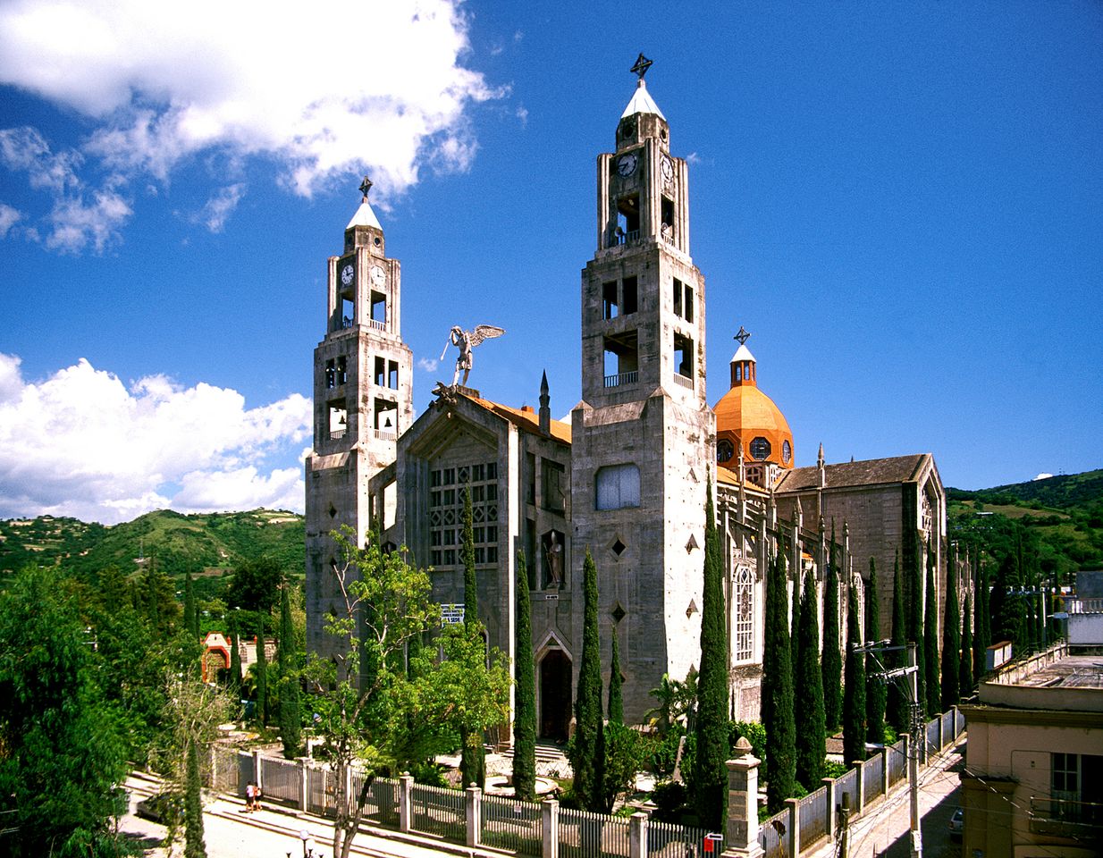
The tianguis sets up beside the cathedral, a huge church dedicated to the Assumption. An earlier church was destroyed by fire in 1930, and the architect Federico Mariscal designed the new one, built between 1931 and 1975 in a nationalist style with five naves and a façade carved in pink and green local stone, crowned by St Michael casting out the devil. Chilapa and nearby Atzacoaloya, Acatlán, Zitlala and Atempa also keep the craft of weaving rebozos on colonial pedal looms, though only a few workshops remain. In April the 'Tigrada' processions of jaguar dancers go round the city's barrios.
How to get to Chilapa de Álvarez
Drive from Chilpancingo: 55 min, 64 km
Chilapa is a little over an hour from Chilpancingo, about 54 km east on federal Highway 93 towards Tlapa. In September 2026 the Sunday tianguis was being held under heavy Army and National Guard presence after a security operation in the town, and the US government currently advises against all travel to Guerrero state.
Directions to Chilapa de Álvarez on Google Maps
Distances are in a straight line; the road is usually longer.
Links open a partner site. We may earn a commission if you book, at no cost to you.
From the nearest cities to Chilapa de Álvarez
- Chilpancingo · 64 km by road, 55 min
- Tlapa · 124 km by road, 1 h 55 min
- Acapulco · 169 km by road, 2 h 5 min
Drive times by road from OpenStreetMap, without traffic or stops. Times marked ~ are estimated from the straight-line distance.
Before you go to Chilapa de Álvarez: hours, prices and tips
- Best time of day
- Chilapa is mild at about 1,400 m: rains fall from June to September, April to June are hottest (over 30 °C) and December and January nights can drop to 9 °C. Wikipedia · checked Oct 2026
- Best season
- The tianguis is held every Sunday from about 6am around the Eucaria Apreza roundabout. Guacamole (Radio Fórmula) · checked Oct 2026
- What to bring
- Cash: traders sell directly with no middlemen, and some still trade by barter. Buzos · checked Oct 2026
Hours and prices change, especially around holidays. Each fact links to where we checked it.
Visiting Chilapa de Álvarez: what to see and do
Go early on a Sunday to the tianguis around the Eucaria Apreza roundabout.
Buy palm weaving, tiger masks, painted pottery and Olinalá lacquer boxes from the people who make them.
Eat green pozole or pozole with pig's trotters at the market stalls, with a mezcal.
See the cathedral's carved pink and green stone façade.
Look for rebozos woven on pedal looms in Chilapa's workshops.
Plan your trip
Places to stay in Chilapa de Álvarez
Compare hotels, posadas, and rentals in and around Chilapa de Álvarez.
Tours & activities
Day trips and guided outings from Guerrero often include Chilapa de Álvarez; with a local guide you can get there without a car.
Mobile data
Signal can drop away from Guerrero: download a map of the way to Chilapa de Álvarez before you set out, or carry an eSIM with data.
Links open a partner site. We may earn a commission if you book, at no cost to you.
Photos
Closest to Chilapa de Álvarez
-
Cueva de Oxtotitlán · Cave · 7 km away
-
Grutas de Juxtlahuaca · Cave · 17 km away
-
Tixtla de Guerrero · Town · 23 km away
-
El Santuario · Landmark · 24 km away
-
Chilpancingo · City · 35 km away
-
Teopantecuanitlán · Archaeological site · 35 km away
Near Chilapa de Álvarez




Drive times by road from OpenStreetMap, without traffic. Times marked ~ are estimated from the straight-line distance.
Location from OpenStreetMap. Written by Puebloteca.