Town Cuautitlán de García Barragán, Jalisco
Municipal seat in Jalisco's southern coast region, at the edge of the Sierra de Manantlán, with a Nativity fiesta each 8 September.
From Manzanillo: 1 h 25 min by car (67 km by road) How to get there ↓
Near here
See everything nearby ↓


Plan your visit to Cuautitlán de García Barragán
Where to stay near Cuautitlán de García Barragán
Compare hotels, posadas and guest houses in Cuautitlán de García Barragán.
Tours to Cuautitlán de García Barragán
Day trips around Comala sometimes stop in Cuautitlán de García Barragán; a tour is the easy way to see it without a car.
 Tours from Manzanillo
Private Chichen Itza & Yaxunah Ruins with Cenote
★ 4.8 (111) · From US$518
How to get to Cuautitlán de García Barragán
- From Manzanillo: about 1 h 25 min by road (~67 km)
- Nearest airport: Colima (CLQ), 32 min by car to Comala
Links open a partner site. We may earn a commission if you book, at no cost to you.
Tours from Manzanillo, near Cuautitlán de García Barragán


Tours, prices and ratings from Viator, checked weekly. We may earn a commission if you book.
About Cuautitlán de García Barragán
Cuautitlán de García Barragán is the seat of the municipality of the same name in Jalisco's southern coast region, at about 589 metres above sea level. The 2020 census counted 2,794 people, 15% of the municipality's 18,370, spread over 121 localities. The name comes from Nahuatl and means 'place among trees'; García Barragán was added in 1987 to honour Marcelino García Barragán, born in the municipality, who is credited with bringing electric light, drinking water and a public clock.
The area belonged to the Cuzalapa chiefdom. In 1522 five Spaniards took possession of the land, and a royal decree that year granted land to the original town, Hueumititlán, about 7 km from the present site. In 1855 Bishop Pedro Espinosa recommended moving it as unhealthy and the residents founded Pueblo Nuevo at Las Pilas; the original name was restored in 1884. It was a comisaría of Villa Purificación, passed to Casimiro Castillo in 1943, and became a municipality on 14 November 1946.
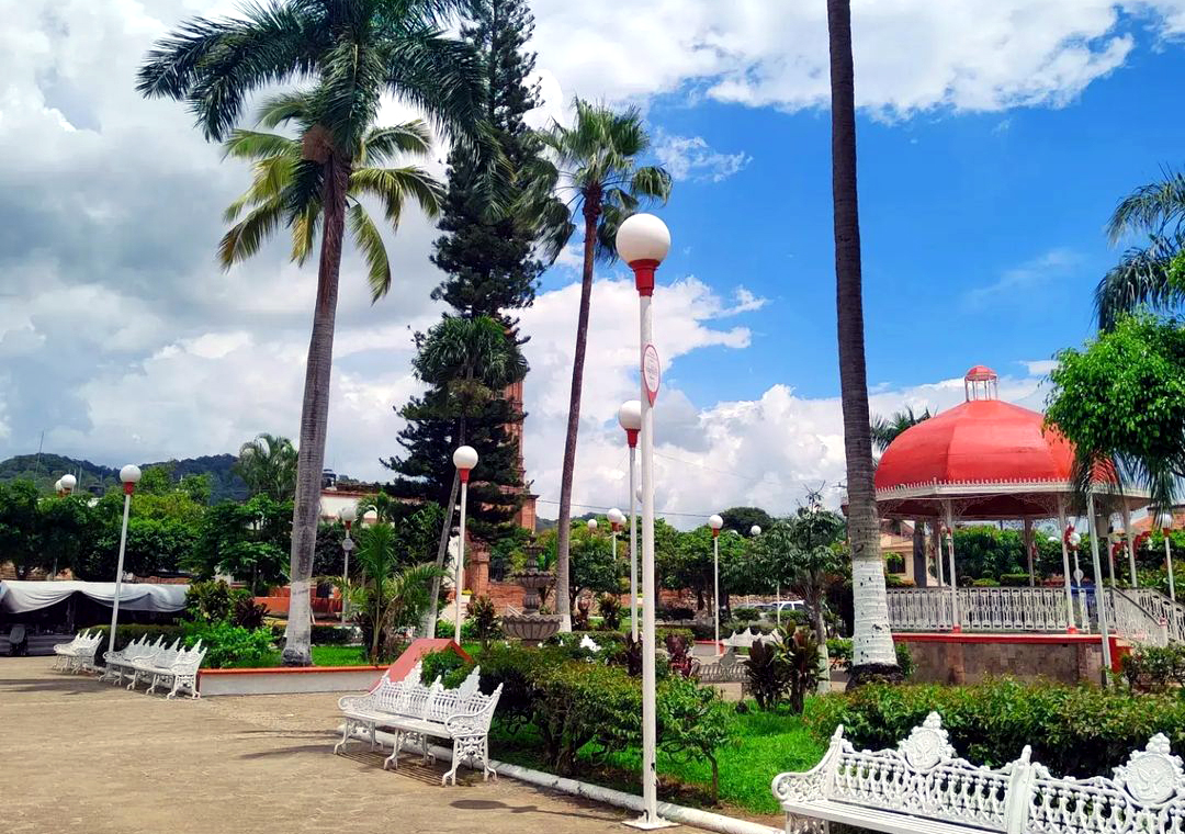
The setting is mountain country: about 61% of the municipality is mountainous, forest covers 68%, and the Sierra de Manantlán Biosphere Reserve takes up 35%. The Marabasco and Minatitlán rivers run through it, and the Chacala river flows by the town, where chacales, freshwater prawns, are a local dish. In the centre are the main plaza, the parish of Nuestra Señora de la Natividad, the casa de la cultura and a community museum. Local food includes birria, pozole, barbacoa and guava roll, and local crafts include basketry, woven mats and saddles.
How to get to Cuautitlán de García Barragán
Drive from Manzanillo: 1 h 25 min, 67 km
By car from Guadalajara, take toll highway 54D toward Colima and Manzanillo, exit at Acatlán de Juárez onto federal highway 80 toward Melaque, and take the turn-off before La Concepción toward Cuautitlán; the last stretch is rural road and dirt track. Route planners estimate about 4 hours of driving from Guadalajara. By bus, the listed options are Primera Plus from the Nueva Central Camionera to Casimiro Castillo (about 5 hours, three departures a day) and then a taxi, or a bus from the Tlaquepaque central to Autlán de Navarro (about 2 h 40 min) and a taxi of approx. 1 h 30 min. Confirm schedules at the terminal.
Directions to Cuautitlán de García Barragán on Google Maps
Distances are in a straight line; the road is usually longer.
Links open a partner site. We may earn a commission if you book, at no cost to you.
From the nearest cities to Cuautitlán de García Barragán
- Manzanillo · 67 km by road, 1 h 25 min
- Autlán · 80 km by road, 1 h 45 min
- Tecomán · 118 km by road, 1 h 55 min
Drive times by road from OpenStreetMap, without traffic or stops. Times marked ~ are estimated from the straight-line distance.
Before you go to Cuautitlán de García Barragán: hours, prices and tips
- Best season
- Fiesta of Nuestra Señora de la Natividad 31 August–8 September, with novena, processions and pilgrimages; bullfighting fair on the second Sunday of May. Wikipedia: Municipio de Cuautitlán de García Barragán · checked Oct 2026
Hours and prices change, especially around holidays. Each fact links to where we checked it.
Visiting Cuautitlán de García Barragán: what to see and do
Stroll the main plaza and the parish of Nuestra Señora de la Natividad.
Visit the casa de la cultura and the community museum.
Go down to the Chacala river and try chacales, freshwater prawns.
Explore the Sierra de Manantlán Biosphere Reserve and the Ameyalco ecotourism development.
Come for the Nativity fiesta, 31 August to 8 September.
Plan your trip
Places to stay in Cuautitlán de García Barragán
Compare hotels, posadas, and rentals in and around Cuautitlán de García Barragán.
Tours & activities
Day trips around Comala sometimes stop in Cuautitlán de García Barragán; a tour is the easy way to see it without a car.
Rental cars
Pick up a car at CLQ (Colima): about 32 min by road to Comala, then 64 km more to Cuautitlán de García Barragán, on your own schedule.
Flights
The nearest airport with scheduled flights is Colima (CLQ), about 32 min by road from Comala, the base for Cuautitlán de García Barragán.
Mobile data
Signal can drop away from Comala: download a map of the way to Cuautitlán de García Barragán before you set out, or carry an eSIM with data.
Links open a partner site. We may earn a commission if you book, at no cost to you.
When to go to Cuautitlán de García Barragán warm
Cuautitlán de García Barragán shares the climate of Comala, 64 km away. The best months to visit are January, February, November, and December.
See the month-by-month climate of Comala
Weather in Cuautitlán de García Barragán now and the next 7 days
Live forecast from Open-Meteo. Chance of rain is the day's highest.
The closest Pueblo Mágico: Comala

Comala is the Pueblo Mágico closest to Cuautitlán de García Barragán, with places to stay, food, and more to see.
Closest to Cuautitlán de García Barragán
-
Cihuatlán · Town · 32 km away
-
Autlán de Navarro · City · 35 km away
-
Playa Miramar · Beach · 37 km away
-
La Boquita · Beach · 39 km away
-
Playa La Audiencia · Beach · 39 km away
-
El Grullo · Town · 42 km away
-
Barra de Navidad · Village · 44 km away
-
San Patricio · Town · 44 km away


Near Cuautitlán de García Barragán




Drive times by road from OpenStreetMap, without traffic. Times marked ~ are estimated from the straight-line distance.
Location from OpenStreetMap. Written by Puebloteca.