


Beach Santa María Huatulco, Oaxaca Municipality of Santa María Huatulco Oaxaca Coast
A wild, 1 km beach in Huatulco National Park, sheltered by an island and backed by dunes; reached on a forest trail or by boat.
Reached on foot from Cacaluta trailhead car park: 45 min each way. How to get there ↓
Near here
See everything nearby ↓


Plan your visit to Bahía de Cacaluta
Where to stay near Bahía de Cacaluta
Compare hotels, posadas and guest houses in Bahía de Cacaluta.
Tours to Bahía de Cacaluta
Day trips and guided outings from Mazunte often include Bahía de Cacaluta; with a local guide you can get there without a car.
 Tours from Huatulco
Tour to Copalitilla Magical Waterfalls from Huatulco with admission included
★ 4.9 (414) · From US$55
How to get to Bahía de Cacaluta
- Reached on foot from Cacaluta trailhead car park: 45 min each way.
- From Salina Cruz: about 1 h 55 min by road (~151 km)
- Nearest airport: Huatulco (HUX), 44 min by car to Mazunte
Links open a partner site. We may earn a commission if you book, at no cost to you.
Tours from Huatulco, near Bahía de Cacaluta


Tours, prices and ratings from Viator, checked weekly. We may earn a commission if you book.
About Bahía de Cacaluta
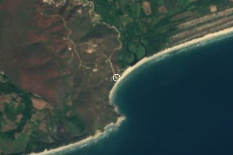
Cacaluta is one of the five bays inside Huatulco National Park, west of Maguey and east of Chachacual, in the municipality of Santa María Huatulco. Its name is linked to the cacalote, a black bird of the crow family. The main beach is a curve of about 1 km of soft pale sand backed by dunes, with Isla Cacaluta sitting across the mouth of the bay and sheltering it; the bay's outline is often described as heart-shaped. A second, smaller beach has coarser sand and gentler waves.
Nothing has been built here and there are no services, which is why Cacaluta is counted among the least spoiled of Huatulco's nine bays. The park was decreed on 24 July 1998; about 55 percent of the Cacaluta river's 49 km² watershed lies inside it, along with the seasonal Zanate lagoon behind the beach and the smaller Cacaluta lagoon nearer the sea. Migratory birds arrive every year. The bay was a filming location for Alfonso Cuarón's 2001 road movie Y tu mamá también.
Swimming is possible, but there can be an undertow, and there is snorkelling a short swim from shore. Most visitors arrive on boat tours from the Santa Cruz pier; the alternative is a walk of roughly 45 minutes through dry forest from the end of the paved road, past the Zanate lagoon.
How to get to Bahía de Cacaluta
Drive from Salina Cruz to Cacaluta trailhead car park: 1 h 55 min, 151 km
From Santa Cruz take the road toward Maguey; about 200 m before Maguey a sign marks the turn to the right for Cacaluta (not the earlier service road signed "Tanque Cacaluta", which dead-ends). Drive about 2 km to a small car park where the paved road ends, then walk roughly 45 minutes to the beach; motorbikes are not allowed on the trail. Taxis can drop you at the entrance, but for the ride back you may need to walk about 1 km to the taxi stand at Maguey. Boats from the Santa Cruz pier are the easiest option.
Reached on foot from Cacaluta trailhead car park: 45 min each way.
Directions to Bahía de Cacaluta on Google Maps
Distances are in a straight line; the road is usually longer.
Links open a partner site. We may earn a commission if you book, at no cost to you.
From the nearest cities to Bahía de Cacaluta
- Salina Cruz · 151 km by road, 1 h 55 min to Cacaluta trailhead car park, then 45 min on foot
- Juchitán · 193 km by road, 2 h 35 min to Cacaluta trailhead car park, then 45 min on foot
- Oaxaca · 285 km by road, 4 h 10 min to Cacaluta trailhead car park, then 45 min on foot
Drive times by road from OpenStreetMap, without traffic or stops. Times marked ~ are estimated from the straight-line distance.
Before you go to Bahía de Cacaluta: hours, prices and tips
- Time needed
- Allow about 45 minutes each way on foot from the car park. The Eye Huatulco · checked Oct 2026
- What to bring
- There are no services on the beach: bring water, food and sun protection. Lonely Planet · checked Oct 2026
- Rules
- The trail is for walkers and bicycles only, no motorbikes; a park ranger may ask to see your park wristband, and all rubbish must be carried out. The Eye Huatulco · checked Oct 2026
Hours and prices change, especially around holidays. Each fact links to where we checked it.
Visiting Bahía de Cacaluta: what to see and do
Walk the forest trail from the car park past the Zanate lagoon.
Spend a quiet day on the 1 km beach backed by dunes.
Snorkel a short swim from shore, watching for undertow.
Look out for migratory birds around the lagoons.
See the bay and its island from the water on a boat tour of the bays.
Plan your trip
Places to stay in Bahía de Cacaluta
Compare hotels, posadas, and rentals in and around Bahía de Cacaluta.
Tours & activities
Day trips and guided outings from Mazunte often include Bahía de Cacaluta; with a local guide you can get there without a car.
Rental cars
Pick up a car at HUX (Huatulco): about 44 min by road to Mazunte, then 43 km more to Bahía de Cacaluta, on your own schedule.
Flights
The nearest airport with scheduled flights is Huatulco (HUX), about 44 min by road from Mazunte, the base for Bahía de Cacaluta.
Travel insurance
If you plan on swimming or surfing at Bahía de Cacaluta, check that your policy covers it: some plans leave adventure activities out.
Mobile data
Signal can drop away from Mazunte: download a map of the way to Bahía de Cacaluta before you set out, or carry an eSIM with data.
Links open a partner site. We may earn a commission if you book, at no cost to you.
Photos
When to go to Bahía de Cacaluta warm
Bahía de Cacaluta shares the climate of Mazunte, 43 km away. The best months to visit are January, February, November, and December.
Bahía de Cacaluta is best for swimming and time on the water in the warmest months (March, April, and May); in the rainiest ones (June, August, and September) expect storms in the afternoon.
See the month-by-month climate of Mazunte
Weather in Bahía de Cacaluta now and the next 7 days
Live forecast from Open-Meteo. Chance of rain is the day's highest.
The closest Pueblo Mágico: Mazunte

Mazunte is the Pueblo Mágico closest to Bahía de Cacaluta, with places to stay, food, and more to see.
Closest to Bahía de Cacaluta
-
Bahía El Maguey · Beach · 1 km away
-
Bahía El Órgano · Beach · 2 km away
-
Parque Nacional Huatulco · Nature reserve · 2 km away
-
Bahías de Huatulco · Nature reserve · 4 km away
-
Playa La Entrega · Beach · 4 km away
-
Bahía de Santa Cruz · Beach · 5 km away
-
La Crucecita · Town · 5 km away
-
Bahía de Chahué · Beach · 6 km away


Near Bahía de Cacaluta
-
Bahía de Tangolunda · Beach · Oaxaca
1 h: 45 min on foot back to Cacaluta trailhead car park, then drive -
Parque Eco-Arqueológico Copalita · Archaeological site · Oaxaca
1 h 10 min: 45 min on foot back to Cacaluta trailhead car park, then drive -
Río Copalita · Nature reserve · Oaxaca
1 h 10 min: 45 min on foot back to Cacaluta trailhead car park, then drive -
Santa María Huatulco · Town · Oaxaca
1 h 20 min: 45 min on foot back to Cacaluta trailhead car park, then drive -
Barra de la Cruz · Beach · Oaxaca
1 h 30 min: 45 min on foot back to Cacaluta trailhead car park, then drive -
San Pedro Pochutla · Town · Oaxaca
1 h 40 min: 45 min on foot back to Cacaluta trailhead car park, then drive -
Santa María Tonameca · Town · Oaxaca
1 h 45 min: 45 min on foot back to Cacaluta trailhead car park, then drive -
Puerto Ángel · Town · Oaxaca
1 h 45 min: 45 min on foot back to Cacaluta trailhead car park, then drive -
Playa Estacahuite · Beach · Oaxaca
1 h 45 min: 45 min on foot back to Cacaluta trailhead car park, then drive -
Zipolite · Beach · Oaxaca
1 h 45 min: 45 min on foot back to Cacaluta trailhead car park, then drive -
Playa La Boquilla · Beach · Oaxaca
1 h 50 min: 45 min on foot back to Cacaluta trailhead car park, then drive -
Pluma Hidalgo · Village · Oaxaca
1 h 50 min: 45 min on foot back to Cacaluta trailhead car park, then drive






Drive times by road from OpenStreetMap, without traffic. Times marked ~ are estimated from the straight-line distance.
Lists with Bahía de Cacaluta
Beaches in Oaxaca · 19 Beaches near Mazunte · 16Location from OpenStreetMap. Written by Puebloteca.