Village Yauhquemehcan, Tlaxcala Municipality of Yauhquemehcan
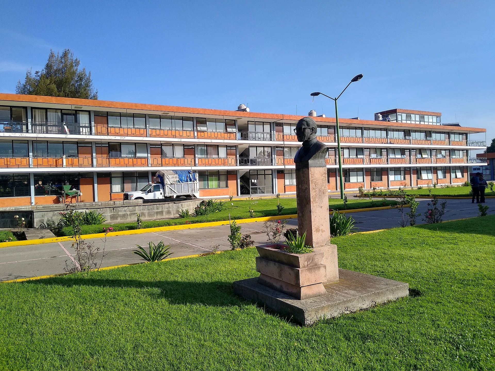
Locality in Yauhquemehcan devoted to Our Lady of the Rosary, at 2,400 m and next to the Diocesan Seminary of Tlaxcala.
From Chiautempan: 10 min by car (10 km by road) How to get there ↓
Near here
See everything nearby ↓


Plan your visit to El Rosario Ocotoxco
Where to stay near El Rosario Ocotoxco
Compare hotels, posadas and guest houses in El Rosario Ocotoxco.
Tours to El Rosario Ocotoxco
Day trips and guided outings from Tlaxco often include El Rosario Ocotoxco; with a local guide you can get there without a car.
 Tours from Puebla City
Africam Safari Zoo Admission with Transportation
★ 4.8 (87) · From US$35
How to get to El Rosario Ocotoxco
- From Chiautempan: about 10 min by road (~10 km)
- Nearest airport: Puebla (PBC), 1 h 6 min by car to Tlaxco
Links open a partner site. We may earn a commission if you book, at no cost to you.
Tours from Puebla City, near El Rosario Ocotoxco


Tours, prices and ratings from Viator, checked weekly. We may earn a commission if you book.
About El Rosario Ocotoxco
El Rosario Ocotoxco is a locality in the municipality of Yauhquemehcan, in central Tlaxcala, at about 2,400 metres above sea level. The Rosario of the name refers to its patron, Our Lady of the Rosary, and Ocotoxco is of Nahuatl origin; sources translate it in different ways, including place of the lynxes and place of the wildcat. The censuses show a small place growing slowly: 266 residents in 1940, 228 in 1960, 436 in 1980, 818 in 2000, 895 in 2010 and 1,032 at the 2020 census.
In its area stands the Diocesan Seminary of Tlaxcala, a complex of modern multi-storey buildings with gardens, which appears among the locality's images on Wikipedia. The rest of the landscape is that of the plateau between the Sierra Nevada and the foothills of La Malinche: to the southwest rise Loma San Matías (2,394 m) and Cerro El Fuerte (2,575 m), and the Zahuapan river runs through the area.
The neighbouring localities are very close together: the barrio of Atencingo a little over a kilometre away, San Lorenzo Tlacualoyan at 1.6 km, Santa María Atlihuetzía at 1.7 km and Santa Úrsula Zimatepec at 1.9 km. Atlihuetzía keeps its Franciscan church laid out in 1523, with open chapel and arcade, and the municipal seat, San Dionisio Yauhquemehcan, has the parish dating from about 1670 with a facade of grey Xaltocan stone.
How to get to El Rosario Ocotoxco
Drive from Chiautempan: 10 min, 10 km
El Rosario Ocotoxco is about 2 to 4 km from San Dionisio Yauhquemehcan, the municipal seat, in the Tlaxcala-Apizaco metropolitan zone; Apizaco borders the municipality to the north and east. Santa María Atlihuetzía is 1.7 km away and Santa Úrsula Zimatepec 1.9 km, so it can be combined with them. According to Pueblos de América, Tlaxco is about 34 minutes by car. There are no published bus lines or colectivos for the locality, and residents cite transport as a shortcoming; the most practical way is by car or to ask in Apizaco or at the municipal seat. Figures are approximate.
Directions to El Rosario Ocotoxco on Google Maps
Distances are in a straight line; the road is usually longer.
Links open a partner site. We may earn a commission if you book, at no cost to you.
From the nearest cities to El Rosario Ocotoxco
- Chiautempan · 10 km by road, 10 min
- San Martín Texmelucan · 34 km by road, 25 min
- Huamantla · 34 km by road, 25 min
Drive times by road from OpenStreetMap, without traffic or stops. Times marked ~ are estimated from the straight-line distance.
Visiting El Rosario Ocotoxco: what to see and do
Diocesan Seminary of Tlaxcala, in the locality's area.
Franciscan church of Santa María Atlihuetzía, laid out in 1523, 1.7 km away.
Parish of San Dionisio in the municipal seat, from about 1670.
Loma San Matías and Cerro El Fuerte, to the southwest.
Plan your trip
Places to stay in El Rosario Ocotoxco
Compare hotels, posadas, and rentals in and around El Rosario Ocotoxco.
Tours & activities
Day trips and guided outings from Tlaxco often include El Rosario Ocotoxco; with a local guide you can get there without a car.
Rental cars
Pick up a car at PBC (Puebla): about 1 h 6 min by road to Tlaxco, then 26 km more to El Rosario Ocotoxco, on your own schedule.
Flights
The nearest airport with scheduled flights is Puebla (PBC), about 1 h 6 min by road from Tlaxco, the base for El Rosario Ocotoxco.
Mobile data
Signal can drop away from Tlaxco: download a map of the way to El Rosario Ocotoxco before you set out, or carry an eSIM with data.
Links open a partner site. We may earn a commission if you book, at no cost to you.
When to go to El Rosario Ocotoxco cool
El Rosario Ocotoxco shares the climate of Tlaxco, 26 km away. The best months to visit are January, February, November, and December.
See the month-by-month climate of Tlaxco
Weather in El Rosario Ocotoxco now and the next 7 days
Live forecast from Open-Meteo. Chance of rain is the day's highest.
The closest Pueblo Mágico: Tlaxco

Tlaxco is the Pueblo Mágico closest to El Rosario Ocotoxco, with places to stay, food, and more to see.
Also close to
- Huamantla · Tlaxcala · 28 km away
- Ixtenco · Tlaxcala · 30 km away
- Huejotzingo · Puebla · 35 km away
- Cholula · Puebla · 39 km away
- Chignahuapan · Puebla · 52 km away
Closest to El Rosario Ocotoxco
-
San Lorenzo Tlacualoyan · Village · 1 km away
-
Atlihuetzía · Town · 2 km away
-
Ex Convento de Santa María de la Concepción Atlihuetzia · Landmark · 2 km away
-
San Benito Xaltocan · Town · 2 km away
-
San Francisco Tlacuilohcan · Village · 2 km away
-
Yauhquemehcan · Town · 2 km away
-
Museo Casa de Piedra · Landmark · 4 km away
-
San Damián Tlacocalpan · Village · 4 km away


Near El Rosario Ocotoxco


Drive times by road from OpenStreetMap, without traffic. Times marked ~ are estimated from the straight-line distance.
Location from OpenStreetMap. Written by Puebloteca.