Town Yauhquemehcan, Tlaxcala Municipality of Yauhquemehcan
Village between Tlaxcala and Apizaco with waterfalls on the Zahuapan River and the ruined friary where child martyr Saint Cristóbal died.
From Chiautempan: 10 min by car (8 km by road) How to get there ↓
Near here


Plan your visit to Atlihuetzía
Where to stay near Atlihuetzía
Compare hotels, posadas and guest houses in Atlihuetzía.
Tours to Atlihuetzía
Day trips around Tlaxco sometimes stop in Atlihuetzía; a tour is the easy way to see it without a car.
 Tours from Puebla City
Africam Safari Zoo Admission with Transportation
★ 4.8 (87) · From US$35
How to get to Atlihuetzía
- From Chiautempan: about 10 min by road (~8 km)
- Nearest airport: Puebla (PBC), 1 h 6 min by car to Tlaxco
Links open a partner site. We may earn a commission if you book, at no cost to you.
Tours from Puebla City, near Atlihuetzía


Tours, prices and ratings from Viator, checked weekly. We may earn a commission if you book.
About Atlihuetzía
Santa María Atlihuetzian, usually called Atlihuetzía, is a village in the municipality of Yauhquemehcan, south of Apizaco and about halfway to Tlaxcala city. The Nahuatl name means "where the water falls", after the two waterfalls the Zahuapan River makes here, and it had 3,122 residents at the 2020 census. It lies beside the Tlaxcala-Apizaco road, near the junction known as la "Y", where travellers and freight heading for Mexico City, Puebla and Veracruz pass every day.
When Cortés arrived, the local lord was Acxotécatl. His son Cristóbal, born around 1514 and taught by the Franciscans, tried to turn his family away from the old gods, and in 1527 his father beat him and threw him into a fire; he died a few hours later. With Antonio and Juan, two boys from Tizatlán killed around 1529, he is counted among the first martyrs of the Americas: John Paul II beatified them at the Basilica of Guadalupe on 6 May 1990 and Pope Francis canonised them on 15 October 2017.
The village's great monument is the Franciscan friary of Santa María de la Concepción, one of the earliest in the region, begun around 1525 and finished over the 16th century. It lost its roof in the 18th century and a cyclone brought down its tower in July 1882, so today it is an open-air nave of stone and brick, with a fine arcade and fragments of a mural showing a man at confession while a demon urges him to lie. On 23 September 2014 Bishop Francisco Moreno Barrón declared it the sanctuary of the Child Martyrs, and its 4-metre iron gate, a gift from sculptor Ángela Gurría, was unveiled the same day.
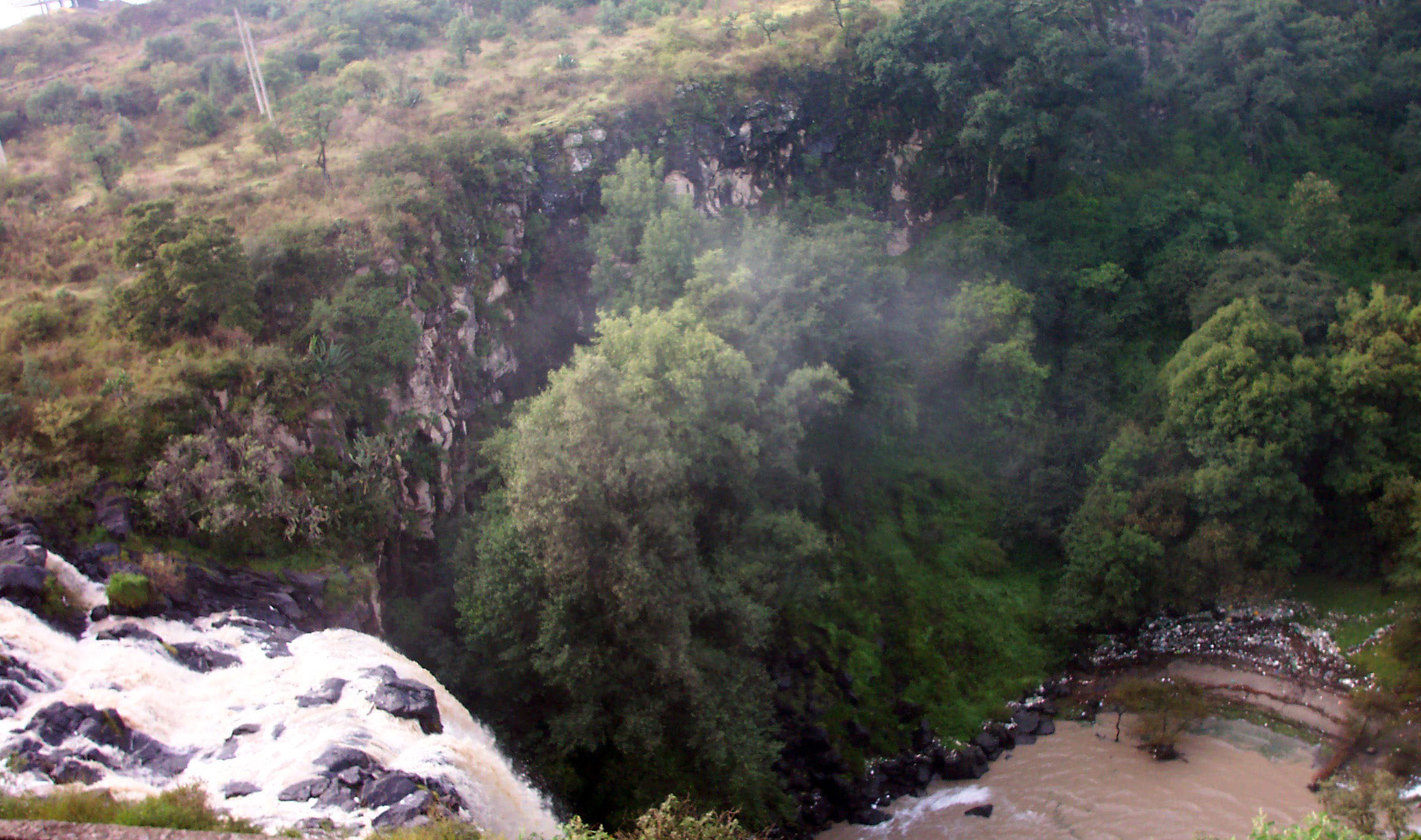
The Zahuapan falls drop into a ravine thick with vegetation and a small pool at the bottom; nearby, villagers found rock paintings on the boulders. 23 September is the village's big day, with thousands of pilgrims and children processing for the martyrs, and the patronal feast of the Immaculate Conception brings evening luminarias in the churchyard, fairground rides and dances.
How to get to Atlihuetzía
Drive from Chiautempan: 10 min, 8 km
Atlihuetzía is on the Tlaxcala-Apizaco road, about halfway between the two cities; from central Tlaxcala it is about 9 km north-east in a straight line, near the Atlihuetzía bridge and the junction known as la "Y". The waterfalls are right by the village, beside the Calinda hotel, and the friary stands on the main square. Buses reach Tlaxcala from Mexico City's TAPO terminal (about 1 hr 50 min; ATAH and Suprabus hourly) and from Puebla (about 50 minutes), and local transport between Tlaxcala and Apizaco runs along this road. By road it is about 144 km from central Mexico City. Huamantla, the nearest Pueblo Mágico, is about 28 km away and Puebla about 37 km in a straight line.
Directions to Atlihuetzía on Google Maps
Distances are in a straight line; the road is usually longer.
Links open a partner site. We may earn a commission if you book, at no cost to you.
From the nearest cities to Atlihuetzía
- Chiautempan · 8 km by road, 10 min
- San Martín Texmelucan · 32 km by road, 25 min
- Huamantla · 32 km by road, 30 min
Drive times by road from OpenStreetMap, without traffic or stops. Times marked ~ are estimated from the straight-line distance.
What to see in Atlihuetzía 2
Sights with their own page, closest to the centre first.
-
Ex Convento de Santa María de la Concepción Atlihuetzia · Landmark · in the centre
Roofless 16th-century Franciscan ruin on Atlihuetzía's main square, open to the sky since the 18th century and now the shrine of the Child Martyrs of Tlaxcala. -
Zoológico del Altiplano · Landmark · 4 km from the centre
Tlaxcala's state zoo in Apetatitlán: 13.5 hectares of lions, jaguars, Mexican wolves and lemurs, 15 minutes from downtown Tlaxcala.

Map of Atlihuetzía
Neighbourhoods and villages of Atlihuetzía
Part of Atlihuetzía or just outside it, closest first.
-
El Rosario Ocotoxco · Village · 2 km from the centre
Locality in Yauhquemehcan devoted to Our Lady of the Rosary, at 2,400 m and next to the Diocesan Seminary of Tlaxcala. -
Amaxac de Guerrero · Town · 3 km from the centre
Municipal seat of 10,417 people, a former textile-mill area, with the San Bernabé fair on 11 June and catrín carnival groups. -
Belén Atzitzimititlán · Town · 3 km from the centre
A locality of 3,962 people 1.8 km from Apetatitlán, at 2,309 m, with a blue-and-white-towered church and murals at its community office. -
San Lorenzo Tlacualoyan · Village · 3 km from the centre
A locality of Yauhquemehcan with an 18th-century church of San Lorenzo and a patron-saint fiesta on 10 August, with bells all night. -
San Matías Tepetomatitlán · Village · 3 km from the centre
Village of 3,273 people about 6 km from Tlaxcala city, with a church to Saint Matthias and views of the hills to the west. -
Santa Cruz Tlaxcala · Town · 3 km from the centre
Seat of a former textile municipality, with a late-16th-century parish, the San Manuel ex-factory and a carnival of umbrella-bearing dancers. -
San Benito Xaltocan · Town · 4 km from the centre
Locality in Yauhquemehcan larger than its own municipal seat: 6,633 people in 2020; church of San Benito with two towers and a clock. -
San Damián Tlacocalpan · Village · 4 km from the centre
A community of about 970 in Amaxac de Guerrero, with a chapel to San Damián, a September patron-saint fair and a 16th-century codex. -
San Francisco Tlacuilohcan · Village · 4 km from the centre
Village in Yauhquemehcan at 2,436 m, "place of scribes" in Nahuatl, with a St Francis church from 1787 and its own carnival camada. -
San Lucas Tlacochcalco · Town · 4 km from the centre
Fourth-largest locality in Santa Cruz Tlaxcala (3,313 people in 2020), with a 17th-century church restored by INAH in 2023; name means "house of arrows". -
Santa Anita Huiloac · Town · 4 km from the centre
Village just south of Apizaco with an 18th-century church to Saint Anne and a carnival of two camadas that dance lancer and French quadrilles. -
Tecolotla · Village · 4 km from the centre
Locality in Apetatitlán de Antonio Carvajal at 2,277 m with 926 residents in 2020, a few kilometres from Tlaxcala city. -
Yauhquemehcan · Town · 4 km from the centre
Municipal seat beside Apizaco with a San Dionisio parish church from about 1670: grey stone façade, stucco tower and a huge gilded main altarpiece.


Day trips and tours from Atlihuetzía
The closest Pueblos Mágicos and places to visit, with the drive from Atlihuetzía and tours that leave from it.


Times marked ~ are estimated from the distance. Links open a partner site. We may earn a commission if you book, at no cost to you.
Before you go: getting to and around Atlihuetzía
- The nearest airport is Puebla (PBC).
- The best months to go are January, February, November, and December.
- 8 of the places on this page are more than 3 km from the centre: take a taxi, a ride-hailing app or a local bus.
- For day trips a rental car gives the most freedom; the tours above leave from Atlihuetzía.
Before you go to Atlihuetzía: hours, prices and tips
- Best season
- 23 September: feast of the Child Martyrs, with pilgrims and a children's procession. The patronal feast is the Immaculate Conception, with luminarias, fairground rides and dances. On 2 August the friary's Porciúncula door is opened. Wikipedia · checked Oct 2026
- Guide or tour
- A local guide is recommended for the trails down to the falls. Tours: Viator GetYourGuide Escapadah · checked Oct 2026
Hours and prices change, especially around holidays. Each fact links to where we checked it.
Visiting Atlihuetzía: what to see and do
The friary of Santa María de la Concepción, sanctuary of the Child Martyrs, with its roofless nave and arcade.
The surviving fragments of 16th-century mural painting in the friary.
The waterfalls of the Zahuapan River and the ravine below them.
The rock paintings on the boulders near the falls.
The church of the Immaculate Conception, with saints on its façade and oil paintings by Juan Díaz.
The Puente de la Conquista, a bridge that local tradition attributes to Cortés.
Plan your trip
Places to stay in Atlihuetzía
Compare hotels, posadas, and rentals in and around Atlihuetzía.
Tours & activities
Day trips around Tlaxco sometimes stop in Atlihuetzía; a tour is the easy way to see it without a car.
Rental cars
Pick up a car at PBC (Puebla): about 1 h 6 min by road to Tlaxco, then 28 km more to Atlihuetzía, on your own schedule.
Flights
The nearest airport with scheduled flights is Puebla (PBC), about 1 h 6 min by road from Tlaxco, the base for Atlihuetzía.
Mobile data
Signal can drop away from Tlaxco: download a map of the way to Atlihuetzía before you set out, or carry an eSIM with data.
Links open a partner site. We may earn a commission if you book, at no cost to you.
When to go to Atlihuetzía cool
Atlihuetzía shares the climate of Tlaxco, 28 km away. The best months to visit are January, February, November, and December.
See the month-by-month climate of Tlaxco
Weather in Atlihuetzía now and the next 7 days
Live forecast from Open-Meteo. Chance of rain is the day's highest.
The closest Pueblo Mágico: Tlaxco

Tlaxco is the Pueblo Mágico closest to Atlihuetzía, with places to stay, food, and more to see.
Also close to
- Huamantla · Tlaxcala · 28 km away
- Ixtenco · Tlaxcala · 29 km away
- Huejotzingo · Puebla · 34 km away
- Cholula · Puebla · 37 km away
- Chignahuapan · Puebla · 53 km away
Near Atlihuetzía


Drive times by road from OpenStreetMap, without traffic. Times marked ~ are estimated from the straight-line distance.
Location from OpenStreetMap. Written by Puebloteca.