
Town Yauhquemehcan, Tlaxcala Municipality of Yauhquemehcan
Second-largest locality in Yauhquemehcan (7,826 people in 2020), right beside Apizaco at 2,475 m, with its own carnival dance groups.
From Chiautempan: 20 min by car (16 km by road) How to get there ↓
Near here


Plan your visit to San José Tetel
Where to stay near San José Tetel
Compare hotels, posadas and guest houses in San José Tetel.
Tours to San José Tetel
Day trips around Tlaxco sometimes stop in San José Tetel; a tour is the easy way to see it without a car.
 Tours from Puebla City
Africam Safari Zoo Admission with Transportation
★ 4.8 (87) · From US$35
How to get to San José Tetel
- From Chiautempan: about 20 min by road (~16 km)
- Nearest airport: Puebla (PBC), 1 h 6 min by car to Tlaxco
Links open a partner site. We may earn a commission if you book, at no cost to you.
Tours from Puebla City, near San José Tetel


Tours, prices and ratings from Viator, checked weekly. We may earn a commission if you book.
About San José Tetel
San José Tetel is the second-largest locality in the municipality of Yauhquemehcan, after Santa Úrsula Zimatepec (10,139 inhabitants): the 2020 census counted 7,826, against 2,433 in 1990 and 5,884 in 2010. It lies at 2,475 m above sea level, 1.7 km northeast of San Dionisio Yauhquemehcan, the municipal seat, and a few kilometres from Apizaco. Its patron is Saint Joseph and the name comes from the Nahuatl tetetl, plural of tetl (stone), which Spanish Wikipedia translates as "stones".
Recent growth shows in the figures: about a quarter of residents were born outside Tlaxcala, average schooling is 10.7 years and 99% of homes have piped water and electricity. The climate is temperate highland, with 14 °C on average through the year and some 685 mm of rain, June being the wettest month; the record low is −4 °C (1976) and the heaviest snowfall 1.3 cm in 1987. Around it rise Cerro Matlalohcan (2,640 m) and Cerro Santa Margarita (2,689 m).
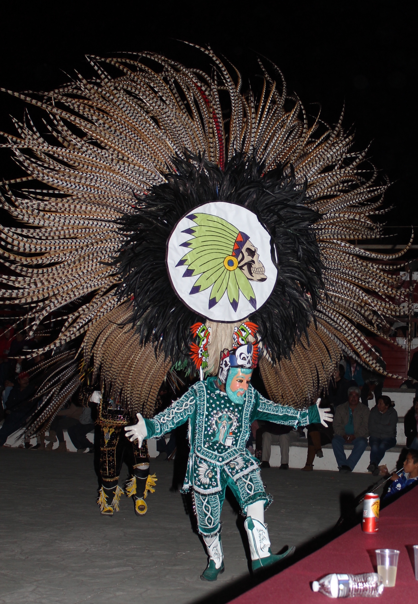
A feature of its own is the carnival: Wikimedia Commons holds a March 2017 photograph of a dance group from San José Tetel, with an embroidered sequin-and-bead costume, a hand-carved mask and an enormous pheasant-feather headdress. Neighbouring localities include San Benito Xaltocan (6,633 inhabitants), Hualcaltzinco and Santa María Atlihuetzian.
How to get to San José Tetel
Drive from Chiautempan: 20 min, 16 km
Tetel is about 3.6 km (roughly 6 minutes by car) from central Apizaco, via avenida México and boulevard Emilio Sánchez Piedras, and 1.7 km from the municipal seat, Yauhquemehcan. From Tlaxcala city it is about 20 km (roughly 21 minutes): take the MEX 117D Tlaxcala–Apizaco toll road, exit onto highway MEX 136 (Los Reyes–Zacatepec) and follow the Camino Real to the village. From Puebla it is about 49 km (roughly 49 minutes) via the MEX 121 and the MEX 117D toll road. Tlaxco, a Pueblo Mágico, is about 33 km away (roughly 39 minutes). Without a car, first reach Tlaxcala, whose bus terminal receives services from TAPO in Mexico City and CAPU in Puebla, then continue by shared transport or taxi; there are no published schedules or route numbers for Tetel.
Directions to San José Tetel on Google Maps
Distances are in a straight line; the road is usually longer.
Links open a partner site. We may earn a commission if you book, at no cost to you.
From the nearest cities to San José Tetel
- Chiautempan · 16 km by road, 20 min
- Huamantla · 30 km by road, 25 min
- San Martín Texmelucan · 40 km by road, 30 min
Drive times by road from OpenStreetMap, without traffic or stops. Times marked ~ are estimated from the straight-line distance.
What to see in San José Tetel 2
Sights with their own page, closest to the centre first.
-
Basílica de Nuestra Señora de la Misericordia (Apizaco) · Landmark · 2 km from the centre
Grey-stone neo-Gothic basilica in central Apizaco, finished in 1961; its two 50 m towers make it the tallest church in Tlaxcala. -
Museo Casa de Piedra · Landmark · 3 km from the centre
A 1916 stone house beside the Apizaco tracks, now a museum of the railway, the city and bullfighting, with a miniature train ride.
Map of San José Tetel
Neighbourhoods and villages of San José Tetel
Part of San José Tetel or just outside it, closest first.
-
Santa Úrsula Zimatepec · Town · 2 km from the centre
Yauhquemehcan locality with a baroque church from about 1737, the Santa Úrsula fiesta on 21 October and a carnival of cuadrillas dances. -
San Benito Xaltocan · Town · 3 km from the centre
Locality in Yauhquemehcan larger than its own municipal seat: 6,633 people in 2020; church of San Benito with two towers and a clock. -
Apizaco · Town · 4 km from the centre
Railway city in central Tlaxcala that grew from a Ferrocarril Mexicano work camp; its emblem is locomotive 212, La Maquinita. -
San Bartolomé Matlalohcan · Town · 4 km from the centre
Locality in Tetla de la Solidaridad that grew from 3,215 to 6,779 people between 2000 and 2020; patron fiesta of St Bartholomew on 24 August. -
San Francisco Atexcatzinco · Town · 4 km from the centre
North Tlaxcala town at 2,509 m whose Nahuatl name means "in the little mirror of water"; it has its own carnival camada and a 17th-century chapel. -
San Lorenzo Tlacualoyan · Village · 4 km from the centre
A locality of Yauhquemehcan with an 18th-century church of San Lorenzo and a patron-saint fiesta on 10 August, with bells all night. -
San Luis Apizaquito · Town · 4 km from the centre
The original San Luis Apizaco, 2 km from Apizaco: the railway city took its name from here. Fiesta 25 August and El Ojito dam. -
Yauhquemehcan · Town · 4 km from the centre
Municipal seat beside Apizaco with a San Dionisio parish church from about 1670: grey stone façade, stucco tower and a huge gilded main altarpiece.


Day trips and tours from San José Tetel
The closest Pueblos Mágicos and places to visit, with the drive from San José Tetel and tours that leave from it.


Times marked ~ are estimated from the distance. Links open a partner site. We may earn a commission if you book, at no cost to you.
Before you go: getting to and around San José Tetel
- The nearest airport is Puebla (PBC).
- The best months to go are January, February, November, and December.
- 6 of the places on this page are more than 3 km from the centre: take a taxi, a ride-hailing app or a local bus.
- For day trips a rental car gives the most freedom; the tours above leave from San José Tetel.
Visiting San José Tetel: what to see and do
Cerro Matlalohcan (2,640 m), about 6 km away, and Cerro Santa Margarita (2,689 m)
The municipal seat, San Dionisio Yauhquemehcan, 1.7 km away
Apizaco, about 3.6 km by road, for food and onward connections
Tlaxco, a Pueblo Mágico, about 33 km away
Plan your trip
Places to stay in San José Tetel
Compare hotels, posadas, and rentals in and around San José Tetel.
Tours & activities
Day trips around Tlaxco sometimes stop in San José Tetel; a tour is the easy way to see it without a car.
Rental cars
Pick up a car at PBC (Puebla): about 1 h 6 min by road to Tlaxco, then 21 km more to San José Tetel, on your own schedule.
Flights
The nearest airport with scheduled flights is Puebla (PBC), about 1 h 6 min by road from Tlaxco, the base for San José Tetel.
Mobile data
Signal can drop away from Tlaxco: download a map of the way to San José Tetel before you set out, or carry an eSIM with data.
Links open a partner site. We may earn a commission if you book, at no cost to you.
When to go to San José Tetel cool
San José Tetel shares the climate of Tlaxco, 21 km away. The best months to visit are January, February, November, and December.
See the month-by-month climate of Tlaxco
Weather in San José Tetel now and the next 7 days
Live forecast from Open-Meteo. Chance of rain is the day's highest.
The closest Pueblo Mágico: Tlaxco

Tlaxco is the Pueblo Mágico closest to San José Tetel, with places to stay, food, and more to see.
Also close to
- Huamantla · Tlaxcala · 28 km away
- Ixtenco · Tlaxcala · 31 km away
- Huejotzingo · Puebla · 40 km away
- Cholula · Puebla · 44 km away
- Chignahuapan · Puebla · 46 km away
Near San José Tetel


Drive times by road from OpenStreetMap, without traffic. Times marked ~ are estimated from the straight-line distance.
Location from OpenStreetMap. Written by Puebloteca.