
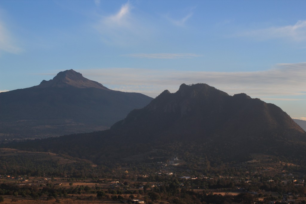
Mountain Cuaxomulco, Tlaxcala La Malinche
A 2,917 m volcanic hill on the flanks of La Malinche, climbed in about an hour from Cuaxomulco on a trail with 14 chapels up to Cristo Rey.
From Chiautempan: 20 min by car (16 km by road) How to get there ↓
Near here
See everything nearby ↓


Plan your visit to Cuatlapanga
Where to stay near Cuatlapanga
Compare hotels, posadas and guest houses in Cuatlapanga.
Tours to Cuatlapanga
Day trips and guided outings from Huamantla often include Cuatlapanga; with a local guide you can get there without a car.
 Tours from Puebla City
Africam Safari Zoo Admission with Transportation
★ 4.8 (87) · From US$35
How to get to Cuatlapanga
- From Chiautempan: about 20 min by road (~16 km)
- Nearest airport: Puebla (PBC), 1 h 5 min by car to Huamantla
Links open a partner site. We may earn a commission if you book, at no cost to you.
Tours from Puebla City, near Cuatlapanga


Tours, prices and ratings from Viator, checked weekly. We may earn a commission if you book.
About Cuatlapanga
Cuatlapanga is a volcanic hill 2,917 metres high on the northern flanks of La Malinche, between the municipalities of San Antonio Cuaxomulco and San José Teacalco. It is also known as "the hill of the face", because its outline looks like a face shouting. The name is usually translated as "split head".
It is a popular hiking destination, and some climbers use it as a short acclimatisation hike before La Malinche. The normal route starts on Calle Guadalupe in Cuaxomulco: it begins as an old dirt track, enters the woods and zigzags up the north face, gaining about 350 to 400 metres in roughly an hour. The trail is well marked. The people of Cuaxomulco have built fourteen small chapels along the way, and on the false summit stands an altar with a figure of Christ the King. Every July a procession climbs the hill, stopping to pray at each chapel and ending with a Mass at the top. Beyond the altar, a short scramble leads to the slightly higher true summit, with La Malinche filling the view to the south and the Tlaxcala valley to the north.
The hill carries a mixed forest of oak, juniper and pine. In 2009 a fire burned much of its pine and oak woodland; reforestation followed and the neighbouring communities banned logging. Dense forest still covers the upper slopes.
How to get to Cuatlapanga
Drive from Chiautempan: 20 min, 16 km
The trail starts in San Antonio Cuaxomulco, on Calle Guadalupe. From Apizaco a colectivo leaves the corner of Jesús Carranza and Benito Juárez, runs through San Andrés Ahuahuatepec and continues to Cuaxomulco; get off at the "La Palma" stop, about half an hour's walk from the trailhead, where the street turns into a track. Taxis also make the trip. By car you can drive to a small church where the road deteriorates and park there. The Autobuses Tlaxcala Apizaco Huamantla (ATAH) line leaves Mexico City's TAPO terminal hourly. Huamantla, the nearest Pueblo Mágico, is about 23 km away, roughly half an hour by car; Puebla is about 35 km in a straight line.
Directions to Cuatlapanga on Google Maps
Distances are in a straight line; the road is usually longer.
Links open a partner site. We may earn a commission if you book, at no cost to you.
From the nearest cities to Cuatlapanga
- Chiautempan · 16 km by road, 20 min
- Huamantla · 24 km by road, 25 min
- San Martín Texmelucan · 43 km by road, 40 min
Drive times by road from OpenStreetMap, without traffic or stops. Times marked ~ are estimated from the straight-line distance.
Before you go to Cuatlapanga: hours, prices and tips
- Time needed
- About an hour up and half an hour down, gaining roughly 350 to 400 m. Steven's Peak-bagging Journey · checked Oct 2026
- Best season
- In July the Cuaxomulco procession climbs the hill, praying at each chapel and holding Mass at the top. SummitPost · checked Oct 2026
Hours and prices change, especially around holidays. Each fact links to where we checked it.
Visiting Cuatlapanga: what to see and do
The fourteen chapels lining the trail from Cuaxomulco.
The Christ the King altar on the false summit.
The true summit, with La Malinche to the south and the Tlaxcala valley to the north.
The "hill of the face" profile, the shouting face traced by its outline.
The oak, juniper and pine forest on the upper slopes.
Plan your trip
Places to stay in Cuatlapanga
Compare hotels, posadas, and rentals in and around Cuatlapanga.
Tours & activities
Day trips and guided outings from Huamantla often include Cuatlapanga; with a local guide you can get there without a car.
Rental cars
Pick up a car at PBC (Puebla): about 1 h 5 min by road to Huamantla, then 18 km more to Cuatlapanga, on your own schedule.
Flights
The nearest airport with scheduled flights is Puebla (PBC), about 1 h 5 min by road from Huamantla, the base for Cuatlapanga.
Travel insurance
If you plan on hiking at altitude at Cuatlapanga, check that your policy covers it: some plans leave adventure activities out.
Mobile data
Signal can drop away from Huamantla: download a map of the way to Cuatlapanga before you set out, or carry an eSIM with data.
Links open a partner site. We may earn a commission if you book, at no cost to you.
When to go to Cuatlapanga cool
Cuatlapanga shares the climate of Huamantla, 18 km away. The best months to visit are January, February, November, and December.
For the clearest views from Cuatlapanga, go in the driest months (January, February, November, and December); in the rains, clouds tend to build up by midday.
See the month-by-month climate of Huamantla
Weather in Cuatlapanga now and the next 7 days
Live forecast from Open-Meteo. Chance of rain is the day's highest.
The closest Pueblo Mágico: Huamantla

Huamantla is the Pueblo Mágico closest to Cuatlapanga, with places to stay, food, and more to see.
Also close to
- Ixtenco · Tlaxcala · 19 km away
- Tlaxco · Tlaxcala · 31 km away
- Huejotzingo · Puebla · 39 km away
- Cholula · Puebla · 39 km away
- Chignahuapan · Puebla · 55 km away
Closest to Cuatlapanga
-
San José Teacalco · Town · 2 km away
-
Cuaxomulco · Town · 3 km away
-
Tzompantepec · Village · 4 km away
-
San Andrés Ahuashuatepec · Town · 5 km away
-
San Felipe Cuauhtenco · Village · 5 km away
-
San Juan Quetzalcoapan · Village · 5 km away
-
San José Aztatla · Town · 6 km away
-
San Lucas Tlacochcalco · Town · 6 km away


Near Cuatlapanga




Drive times by road from OpenStreetMap, without traffic. Times marked ~ are estimated from the straight-line distance.
Lists with Cuatlapanga
Mountains in Tlaxcala · 6 Mountains near Chiautempan · 13 Mountains near Huamantla · 11 Mountains near Puebla · 10 Mountains near San Martín Texmelucan · 16 Mountains near Huejotzingo · 12 Mountains near Cholula · 11 Mountains near Chignahuapan · 3Location from OpenStreetMap. Written by Puebloteca.