
Town Yauhquemehcan, Tlaxcala Municipality of Yauhquemehcan
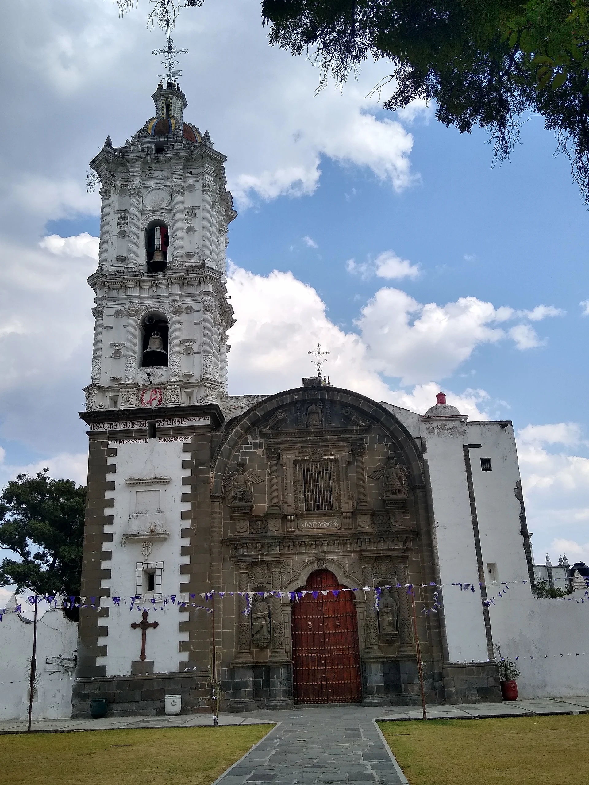
Municipal seat beside Apizaco with a San Dionisio parish church from about 1670: grey stone façade, stucco tower and a huge gilded main altarpiece.
From Chiautempan: 15 min by car (13 km by road) How to get there ↓
Near here


Plan your visit to Yauhquemehcan
Where to stay near Yauhquemehcan
Compare hotels, posadas and guest houses in Yauhquemehcan.
Tours to Yauhquemehcan
Day trips around Tlaxco sometimes stop in Yauhquemehcan; a tour is the easy way to see it without a car.
 Tours from Puebla City
Africam Safari Zoo Admission with Transportation
★ 4.8 (87) · From US$35
How to get to Yauhquemehcan
- From Chiautempan: about 15 min by road (~13 km)
- Nearest airport: Puebla (PBC), 1 h 6 min by car to Tlaxco
Links open a partner site. We may earn a commission if you book, at no cost to you.
Tours from Puebla City, near Yauhquemehcan


Tours, prices and ratings from Viator, checked weekly. We may earn a commission if you book.
About Yauhquemehcan
San Dionisio Yauhquemehcan is the seat of the municipality of Yauhquemehcan in central Tlaxcala, about 2,435 metres up and just 6 km west of Apizaco, within the Tlaxcala-Apizaco metropolitan area. The town had 4,544 inhabitants at the 2020 census, although the municipality, which includes larger places such as Santa Úrsula Zimatepec and San José Tetel, had more than 42,000. The Nahuatl name has been translated as "place of dressed warriors" and also as "place of the pericón garment", after Yauhquemeh, a rain spirit linked to the west, the pericón marigold and lightning.
Yauhquemehcan emerged during the Texcalac phase of Tlaxcalan history as one of the larger towns of the valley, right beside San Martín Xaltocan and Santa Bárbara Acuicuizcatepetl, and became one of the 24 lordships of the Tlaxcalan republic, subject to its four head towns. According to the chronicler Diego Muñoz Camargo, its warriors fought in 1348 in the battle against the Huejotzincas at Tepeticpac. In colonial times the town, home to indigenous noble houses, held on to its land longer than most, and Spaniards did not settle there until the late 17th century. The municipality was created in 1822.
What brings visitors is the parish church of San Dionisio, built around 1670. A wall of inverted arches encloses the atrium, which keeps old gravestones, and the façade is of grey Xaltocan stone, with reliefs of Saint Peter and Saint Paul, Solomonic columns flanking the choir window, a small figure of Saint Dionysius and a trefoil entrance arch; beside it rises a carved stucco tower. Inside are a holy-water font carved by indigenous craftsmen, a Solomonic altarpiece of the Virgen de la Luz, another of the Sacred Heart and a wooden pulpit. The gilded main altarpiece fills the whole semicircular sanctuary with ten estípite columns, a carved Saint Dionysius and twelve 18th-century sculptures, and continues around the apse to end in a Virgin of Guadalupe; the church also holds a painting of the souls in purgatory studied by UNAM's Institute of Aesthetic Research.
Carnival runs from Sunday to Tuesday before Ash Wednesday: the camadas of the four barrios gather in front of the town hall to dance French quadrilles, dressed as Spaniards, Moors and dandies, and on Tuesday they close with a dance in each barrio's hall. The main day of the patron's fair is a Sunday, with a parade and fair queen in the morning, horse races at noon, a mass with the bishop, a tienta of young bulls, music at the kiosk, a procession with the image of San Dionisio and fireworks at night. Local cooking includes turkey mole, mixiotes, chileatole, tlatlapas and anise tamales, with capulín and tejocote preserves.
How to get to Yauhquemehcan
Drive from Chiautempan: 15 min, 13 km
From Tlaxcala city it is about 16 km, roughly 16 minutes: take the 117D Tlaxcala-Apizaco toll road north, exit onto federal highway 136 (Los Reyes-Zacatepec) and after just over 1 km turn into Avenida Yauhquemehcan to the centre. From Apizaco it is about 6 km, roughly 8 minutes, west on the same highway 136. From Puebla it is about 46 km, roughly 45 minutes, on federal highway 121 and the 117D.
By public transport: ATAH buses leave Mexico City's TAPO terminal for Apizaco every hour (about 2 hours); from Apizaco the town is a few minutes away by taxi or local transport.
Directions to Yauhquemehcan on Google Maps
Distances are in a straight line; the road is usually longer.
Links open a partner site. We may earn a commission if you book, at no cost to you.
From the nearest cities to Yauhquemehcan
- Chiautempan · 13 km by road, 15 min
- Huamantla · 35 km by road, 30 min
- San Martín Texmelucan · 36 km by road, 30 min
Drive times by road from OpenStreetMap, without traffic or stops. Times marked ~ are estimated from the straight-line distance.
What to see in Yauhquemehcan 2
Sights with their own page, closest to the centre first.
-
Ex Convento de Santa María de la Concepción Atlihuetzia · Landmark · 4 km from the centre
Roofless 16th-century Franciscan ruin on Atlihuetzía's main square, open to the sky since the 18th century and now the shrine of the Child Martyrs of Tlaxcala. -
Museo Casa de Piedra · Landmark · 4 km from the centre
A 1916 stone house beside the Apizaco tracks, now a museum of the railway, the city and bullfighting, with a miniature train ride.


Map of Yauhquemehcan
Neighbourhoods and villages of Yauhquemehcan
Part of Yauhquemehcan or just outside it, closest first.
-
San Benito Xaltocan · Town · 1 km from the centre
Locality in Yauhquemehcan larger than its own municipal seat: 6,633 people in 2020; church of San Benito with two towers and a clock. -
San Francisco Tlacuilohcan · Village · 1 km from the centre
Village in Yauhquemehcan at 2,436 m, "place of scribes" in Nahuatl, with a St Francis church from 1787 and its own carnival camada. -
San Lorenzo Tlacualoyan · Village · 1 km from the centre
A locality of Yauhquemehcan with an 18th-century church of San Lorenzo and a patron-saint fiesta on 10 August, with bells all night. -
El Rosario Ocotoxco · Village · 2 km from the centre
Locality in Yauhquemehcan devoted to Our Lady of the Rosary, at 2,400 m and next to the Diocesan Seminary of Tlaxcala. -
Santa Úrsula Zimatepec · Town · 3 km from the centre
Yauhquemehcan locality with a baroque church from about 1737, the Santa Úrsula fiesta on 21 October and a carnival of cuadrillas dances. -
Topilco de Juárez · Town · 3 km from the centre
Xaltocan locality founded on 5 December 1973, next to the municipal seat, with a church of Our Lady of Guadalupe. -
Xaltocan · Village · 3 km from the centre
Stone-carvers' municipal seat near Apizaco in central Tlaxcala: San Martín church with a 1720 tower, an 1889 stone bridge and a November fair. -
Atlihuetzía · Town · 4 km from the centre
Village between Tlaxcala and Apizaco with waterfalls on the Zahuapan River and the ruined friary where child martyr Saint Cristóbal died. -
San José Tetel · Town · 4 km from the centre
Second-largest locality in Yauhquemehcan (7,826 people in 2020), right beside Apizaco at 2,475 m, with its own carnival dance groups. -
San Simón Tlatlahuquitepec · Village · 4 km from the centre
The most populous locality in Xaltocan, at 2,541 m, with a church to Saint Simon and reddish hills around it.


Day trips and tours from Yauhquemehcan
The closest Pueblos Mágicos and places to visit, with the drive from Yauhquemehcan and tours that leave from it.


Times marked ~ are estimated from the distance. Links open a partner site. We may earn a commission if you book, at no cost to you.
Before you go: getting to and around Yauhquemehcan
- The nearest airport is Puebla (PBC).
- The best months to go are January, February, November, and December.
- 5 of the places on this page are more than 3 km from the centre: take a taxi, a ride-hailing app or a local bus.
- For day trips a rental car gives the most freedom; the tours above leave from Yauhquemehcan.
Before you go to Yauhquemehcan: hours, prices and tips
- Best season
- Carnival from Sunday to Tuesday before Ash Wednesday, with camadas from the four barrios in front of the town hall. San Dionisio patron's fair, with its main day on a Sunday. INAFED, Enciclopedia de los Municipios · checked Oct 2026
Hours and prices change, especially around holidays. Each fact links to where we checked it.
Visiting Yauhquemehcan: what to see and do
The grey stone façade of the San Dionisio parish church, with Saint Peter and Saint Paul.
The carved stucco bell tower beside the façade.
The gilded main altarpiece with ten estípite columns, running round the apse.
The carved holy-water font and the Solomonic altarpiece of the Virgen de la Luz.
The atrium with its wall of inverted arches and old gravestones.
The carnival camadas dancing in front of the town hall.
Plan your trip
Places to stay in Yauhquemehcan
Compare hotels, posadas, and rentals in and around Yauhquemehcan.
Tours & activities
Day trips around Tlaxco sometimes stop in Yauhquemehcan; a tour is the easy way to see it without a car.
Rental cars
Pick up a car at PBC (Puebla): about 1 h 6 min by road to Tlaxco, then 24 km more to Yauhquemehcan, on your own schedule.
Flights
The nearest airport with scheduled flights is Puebla (PBC), about 1 h 6 min by road from Tlaxco, the base for Yauhquemehcan.
Mobile data
Signal can drop away from Tlaxco: download a map of the way to Yauhquemehcan before you set out, or carry an eSIM with data.
Links open a partner site. We may earn a commission if you book, at no cost to you.
When to go to Yauhquemehcan cool
Yauhquemehcan shares the climate of Tlaxco, 24 km away. The best months to visit are January, February, November, and December.
See the month-by-month climate of Tlaxco
Weather in Yauhquemehcan now and the next 7 days
Live forecast from Open-Meteo. Chance of rain is the day's highest.
The closest Pueblo Mágico: Tlaxco

Tlaxco is the Pueblo Mágico closest to Yauhquemehcan, with places to stay, food, and more to see.
Also close to
- Huamantla · Tlaxcala · 29 km away
- Ixtenco · Tlaxcala · 31 km away
- Huejotzingo · Puebla · 36 km away
- Cholula · Puebla · 41 km away
- Chignahuapan · Puebla · 50 km away
Near Yauhquemehcan


Drive times by road from OpenStreetMap, without traffic. Times marked ~ are estimated from the straight-line distance.
Location from OpenStreetMap. Written by Puebloteca.